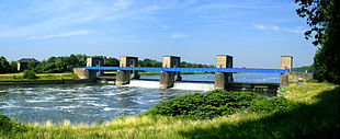
Ruhrwehr Duisburg
The Ruhrwehr Duisburg is located on the Ruhr 2.626 km before it flows into the Rhine. In waterway network of Duisburg are Ruhr , the Ruhr navigation canal and the Rhein-Herne channel connected. From the Rhine it is possible to sail upstream and upstream via the Ruhr and the Ruhr lock Duisburg located here as well as the port canal and the Meiderich lock .
Weir
The locks are designed as a double weir and consist of two retaining walls for each weir opening. The upper weir body is designed as a hook gate and the lower one as a box gate. Both retaining walls can be operated largely independently of one another. The facility with a total width of 150.88 meters has four weir openings, each with a clear width of 30 meters.
The targeted storage target at normal water level is 25.00 m above sea level. The water level of the Duisburg / Mülheim section can only be influenced by the Rhine if it swells up due to extreme floods. In this case, the weir bodies are moved out of the water to ensure unhindered drainage and to avoid damage to the closures from massive debris and debris.
lock
Return pumping station Duisburg (out of operation)
The re- pumping station of the barrage was the first of the eight re-pumping stations in the Ruhr and is still located on the island between the lock and the weir. The pumps with an engine output of 710 kilowatts and a delivery rate of 5,000 liters per second could, if necessary, pump the water 7.30 meters high back into the upper water . After the plant was shut down, the pumps and the electrical system were dismantled. Parts of a pump are exhibited opposite the still existing company building.
Position: 51 ° 26 '41.9 " N , 6 ° 45' 15.6" O .
Duisburg-Meiderich return pumping station (in operation)
The new Duisburg-Meiderich pumping station is located on the Rhine-Herne Canal km 0.135 in the immediate vicinity of the Duisburg ports . The facility was also rebuilt in the early 1980s as part of the construction of the Duisburg-Meiderich entrance lock at the beginning of the Rhine-Herne Canal. It replaces the Duisburg pumping station, which was decommissioned at the end of the 1990s.
The pumping station is primarily used for water management in the Duisburg / Oberhausen (RHK) and Duisburg / Mülheim (Ruhr) lines. Compared to other pumping stations, it only plays a subordinate role, as the reaches are mainly fed by the Ruhr River.
Position: 51 ° 26 '56.5 " N , 6 ° 45' 58.7" O .
Energy generation
The Stadtwerke Duisburg planned since 2012 a hydroelectric power plant at Ruhr weir, but now this project has been set.
Biological permeability
A pool pass does not allow the desired permeability for aquatic life. As of 2010 it was said: "Salmon can only make it if they use the rare opportunities of an open lock on the Rhine-Ruhr connection in Duisburg."
See also
Web links
Individual evidence
- ↑ Stadtwerke Duisburg plan hydropower plant at the Ruhr weir. In: WAZ , June 14, 2013 ( online )
- ↑ Stadtwerke Duisburg stop all eco-projects with water and wind In: WAZ , November 7, 2014 ( online )
- ↑ http://www.hellwegeranzeiger.de/nachrichten/region/hierundheute/heute/Ruhrgebiet-Lachse-fuehlen-sich-in-der-Ruhr-wieder-wohl;art94547,1025699 http://www.hellwegeranzeiger.de/ news / region / here and today / today / Ruhrgebiet-salmon-feel-good-again-in-the-Ruhr; art94547,1025699 ( Memento from June 19, 2013 in the web archive archive.today )
Coordinates: 51 ° 26 '38.7 " N , 6 ° 45' 19.1" O .


