Vincke Canal
The Vinckekanal is a port canal in Duisburg-Ruhrort . It connects the Rhine with the Ruhrort free port area .
history
The Vinckekanal is named after Ludwig Freiherr von Vincke , who became civil governor between the Weser and Rhine in 1813, and in 1816 he was President of the Province of Westphalia and Director of the Ruhr Shipping Administration . He held these administrative offices for almost thirty years.
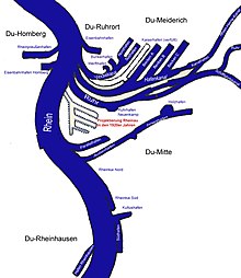
The canal was created by converting the Ruhrort harbor shortly before the First World War . In 1914, the oval island port was largely filled in, the remaining northern remainder is today's shipyard. Schleusenhafen and Hafenmund were also included in the expansion of the Vincke Canal. The reconstruction also included connecting the ports to the Rhine-Herne Canal .
In 1983 the Vinckekanal was expanded again and initially pusher navigation with six barges between the ports of Rotterdam and Duisburg-Ruhrort was permitted on a trial basis , which was then approved in 1987. In 1984 the first container terminal in the southern harbor and the roll on roll off facility at the end of the Vincke Canal went into operation. The Kaiserhafen was filled in from 1996 to 1997; the confluence was up to then just before the harbor fire station. From 2007 to 2008 the north port was filled in and made available as a transshipment area for the free port, so the Vinckekanal now only leads into the south port.
panorama
terrain
The Vinckekanal begins today at the harbor mouth under the Friedrich-Ebert-Brücke . On the Ruhrort side there are initially various works of art, including a tower made of ship's propellers. This is followed by the tower of the port master's office of Duisburger Hafen AG as well as various inland shipping and other companies. The museum ship " Oscar Huber " of the Museum of German Inland Navigation , located further north in the railway port, is located at the Schifferbörse . The thousand-window house is in front of the bridge on Ruhrorter Strasse , followed by the watchtower police immediately on the remains of the shipyard. After the bunker port, the canal flows into the free port area, which consists of the filled-in north port and the expanded south port.
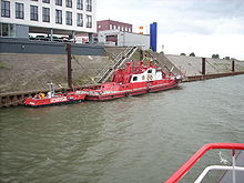
On the other side of the canal, on a pillar of the Friedrich-Ebert-Brücke, begins the former freight forwarding island, now called Mercatorinsel , which is to be expanded into a new cultural island with the support of the Haniel company . Then the harbor fire station follows with the landing stage for the fire watch boats. Various companies and institutions have settled along the canal, including a base for the Malteser relief service . The headquarters of Duisburger Hafen AG, as well as container areas and loading facilities, follow the Ruhrorter Strasse bridge. Both sides of the canal are designed as berths and flood protection.
Web links
- Description of this sight on the route of industrial culture
- History of the Duisburg ports on archive.today (snapshot from duisport.de) ( Memento from March 2, 2006 in the Internet Archive )
Coordinates: 51 ° 26 ′ 57 ″ N , 6 ° 44 ′ 25 ″ E


