
Ruhrort – Homberg route


The Ruhrort – Homberg trajectory was a railway ferry across the Rhine between today's Duisburg districts Ruhrort and Homberg .
history
Simultaneously with the construction of the railway line from Cologne via Duisburg to Minden by the Cologne-Mindener Eisenbahn-Gesellschaft from 1843 to 1847, the shareholders of the Ruhrort-Crefeld-Kreis Gladbacher Eisenbahn-Gesellschaft were looking for a way to get Ruhr coal cheaply to the industries on the left bank of the Rhine bring to.
The technical requirements for building a bridge over the Rhine were not yet fully developed. The Prussian military also opposed the construction of a permanent bridge over the Rhine. Therefore, the Ruhrort-Crefeld-Kreis Gladbacher Eisenbahn-Gesellschaft decided to build a trajectory between their homberg terminus on the left bank of the Rhine and the port of Ruhrort on the right bank of the Rhine.
Construction of the railway lines
On March 29, 1847, the railway company concluded a contract with the Cologne-Mindener Eisenbahn-Gesellschaft to connect the routes of both companies and to transport passenger and freight cars across the Rhine.
Thereupon, the Ruhrort-Crefeld-Kreis Gladbacher Eisenbahn-Gesellschaft began in May 1847 with the construction of their line from Viersen via Krefeld to Homberg and opened it on October 15, 1849. The Cologne-Mindener Eisenbahn-Gesellschaft set its branch line from Oberhausen to Ruhrort on Completed October 14, 1848.
Construction of the ramps and docks
Due to a lack of experience in Germany, the Ruhrort-Crefeld-Kreis Gladbacher Eisenbahn-Gesellschaft decided to start the trajectory of railway wagons with a simple ramp system and to check other options abroad. After separate port basins were dredged on both banks around 1850 - the railway basins still existing today - inclined ramps with an incline of 1:12 were built to overcome the high banks and rails were laid on them right into the water. Locomotives used these tracks to lower the wagons first on chains, later on ropes to the ferry pontoons or pull them back up on the other bank.
The ferry pontoons could each carry three cars. They were attached to both sides of a small steamer and from November 12, 1852, they crossed the Rhine freely. Despite the problems caused by ice and floods and despite many broken chains and ropes, up to 700 wagons could be hauled in this way at the beginning. In 1855 32,000 wagons were driven across the Rhine. However, the limit of performance was reached.
Construction of the hydraulic lifting system
To increase performance, the railway company decided to build a lifting tower with a hydraulically operated lifting platform on each bank next to the ramps . The systems were supplied and installed by an English company. Two freight cars or one passenger car could be moved on a lifting platform in the tower over a height difference of maximum 8.50 meters.
A paddle steamer, 52 meters long and 8 meters wide, specially built for transport , could carry twelve freight cars or four passenger cars on each trip. The ship had four steam boilers and two tall chimneys on each side of the ship. Inside the ship there were rooms for the passengers who did not stay in the car.
Construction of the lifting systems began in the summer of 1854. On May 1, 1856, the new systems went into operation. In the same year 47,050 wagons were transported. By operating the inclined planes, the output could be increased on peak days. However, there were always noticeable business interruptions in the event of storms, ice and floods .
Takeover by the BME
After the Bergisch-Märkische Eisenbahn-Gesellschaft took over the company on January 1, 1866, which until then had been administered by the Royal Directorate of the Aachen-Düsseldorf-Ruhrorter Eisenbahn-Gesellschaft , considerable repair and improvement work began to improve the performance of the To further increase the train station. The inclined ramps were flattened to 1:24 so that longer vehicles could be transported over them. By putting another ferry into service, the performance of the system could be increased to over 100,000 hauled wagons annually.
With the opening of the new coal line of the Rheinische Eisenbahn-Gesellschaft from Osterath near Krefeld via Rheinhausen to Essen with the Rheinhausen – Hochfeld trajectory on August 23, 1866 and above all the Rheinhausen-Hochfelder Rheinbrücke in 1874, the Bergisch-Märkische Eisenbahn-Gesellschaft lost to Nationalization of the private railway companies in 1881, gradually transport volumes for their Homberger Trajekt.
In 1881 the transport performance was still around 80,000 hauled wagons. Nevertheless, the railway company rebuilt the Ruhrort lifting tower of the trajectory in 1876 after a fire.
Cessation of trajectory operation
According to various information in the known literature, the ferry service was stopped on April 1, 1885 by the Royal Prussian State Railway . From this point in time until the opening of the Friedrich-Ebert-Brücke between Homberg and Ruhrort in 1907, it operated a simple ferry service for passenger traffic. On the other hand , it seems doubtful whether the transport of freight wagons was continued until the opening of the Haus-Knipp railway bridge in Baerl in 1912.
The basin bridge over the Ruhrort harbor entrance was built in connection with the northern ramp of the new road bridge over the Rhine. The arched girder bridge with the “German Arch” -type structure was built in 1906/07 by Gutehoffnungshütte . The dilapidated lifting tower on the Ruhrort side was demolished in 1971. Its counterpart in Homberg still stands today and was used at times as a youth hostel . Today it is part of the Route of Industrial Culture .
Today's use of the railway ports
The harbor basins on the Homberger and Ruhrorter side are used nowadays by anglers and sport boat guides. The boarding school ship "Rhein" has been anchored in the Homberg harbor basin since 1946. During the three-month vocational school blocks, the school ship offers the prospective Rhine boatmen accommodation, food and care.
According to the plans of an investor , the Ruhrort railway port was to be expanded into a yacht port in the 1990s, but that did not happen. In 2004, a new promenade was built on the north side of the Ruhrort harbor basin near the Rhine , connecting the center of the old port district of Duisburg-Ruhrort with the Museum of German Inland Shipping . In the summer of 2015 it was the location of a walk-in open-air installation “Nomanslanding” as part of the Ruhrtriennale .
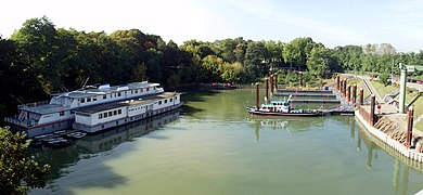
Homberg railway port with the training ship Rhein
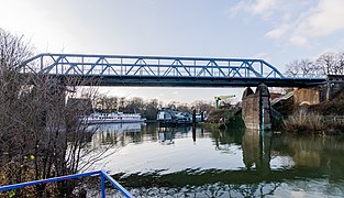
Homberger Eisenbahnhafen: Entrance with a listed bridge

Ruhrort railway port

Ruhrort railway port: Dilapidated overpass
.jpg)


literature
- Bergisch-Märkische Eisenbahn: Annual reports 1865–1881 . Elberfeld.
- Bergisch-Märkische Eisenbahn: The Bergisch-Märkische company in its development during the first 25 years of operation . Elberfeld 1875.
- G. Erbkam: Atlas for the journal for construction . Vol. VII, Berlin 1857 plates 42ff. Download from the Central and State Library Berlin
- VC Gottwald: The Ruhrort harbor, technology and innovation 1800–1870. (= Duisburg research. Volume 39). Duisburg 1991, ISBN 3-87096-050-7 .
- Hans-Paul Höpfner: Railways. Your story on the Lower Rhine . Mercator Verlag, Duisburg 1986, ISBN 3-87463-132-X .
- Hartwig Untouched: Traffic center on the left Lower Rhine, Homberg's unfulfilled dream. In: Yearbook for Rheinhausen and the surrounding area 1986/87. Ed .: Freundeskreis lively Grafschaft eV Duisburg 1986.
- Th. Weishaupt: The Homberg-Ruhrorter Rheintraject-Anstalt. In: Zeitschrift für Bauwesen with Atlas. Volume 8, Berlin 1857.
- Ernst Werner: The Ruhrort-Homberger Rhein-Trajektanstalt. In: Duisburg research. Volume 14, Duisburg 1970, ISBN 3-87096-012-4 , pp. 58-71.
- Ernst Werner: Railway project across the Rhine near Rheinhausen . Duisburg 1979, ISBN 3-87096-156-2 .
- Hans Schlieper: Railway trajectories across the Rhine and Lake Constance . Alba Verlag, Düsseldorf 2009, ISBN 978-3-87094-369-1 .
Web links
- Description of this sight on the route of industrial culture
- History of the Freundeskreis historic Homberg trail
- History of the Homberg-Ruhrort railway port
- Newspaper report about the training ship in the Homberg railway port
Coordinates: 51 ° 27 ′ 16 ″ N , 6 ° 43 ′ 1 ″ E
Visitor center and anchor points (from west to east): Museum of German Inland Shipping | Inner harbor Duisburg | LVR Industrial Museum Oberhausen | Landscape Park Duisburg-Nord | Gasometer Oberhausen | Aquarius Water Museum | St. Antony Hut | Villa Huegel | Nordsternpark | Zeche Zollverein World Heritage Site and Zollverein Coking Plant | Ewald colliery | Marl Chemical Park | Railway Museum Bochum-Dahlhausen | Henrichshütte | Centennial Hall Bochum | Recklinghausen substation | German Mining Museum | Nightingale colliery | Henrichenburg ship lift | DASA | Hansa coking plant | Zeche Zollern II / IV | Hohenhof | Hagen Open Air Museum | Lindenbrauerei Unna | Maximilian Park Hamm
Themed routes (in ascending order by number): 1. Duisburg: City and Harbor | 2. Industrial cultural landscape Zollverein | 3. Duisburg: industrial culture on the Rhine | 4. Oberhausen: Industry makes the city | 5. Krupp and the city of Essen | 6. Dortmund: triad coal, steel and beer | 7. Industrial culture on the Lippe | 8. Erzbahn-Emscherbruch | 9. Industrial culture at Volme and Ennepe | 10. Brine, steam and coal | 11. Early industrialization | 12. The past and present of the Ruhr | 13. On the way to the blue Emscher | 14. Canals and shipping | 15. Lanes in the area | 16. Westphalian mining route | 17. Rhenish mining route | 18. Chemistry, Glass and Energy | 19. Workers' settlements | 20. Entrepreneur villas | 21. Bread, grain and beer | 22. Myth of the Ruhr Area | 23. Parks and Gardens | 24. Industrial nature | 25. Panoramas and Landmarks | 26. Sacred buildings | 27. Iron & Steel | 28. Water: works, towers and turbines | 29. Bochum - industrial culture in the heart of the district | 30. Gelsenkirchen | 31. Industrial Culture and Bauhaus Route | by bike

Museum Küppersmühle |
Port facilities |
Holzgracht |
Werhahnmühle |
Speichergracht |
Port residential complexes Duisburg |
Day care center Hansegracht |
Hansegracht |
Factory 21 |
Duisburg Harbor Forum |
Storage General |
Portsmouth Dam and North Harbor Side |
Eurogate |
Savings headquarters |
Duisburg Holzhafen |
Senior Center |
Garden of Remembrance |
Jewish Community Center |
Footbridge and Marina |
City wall |
Culture and City History Museum |
City Archives |
Swan Gate Bridge |
Office building |
Police technical services |
Steiger Schwanentor - Harbor tour of Duisburg ports |
Steiger Schifferbörse |
Gildeplatz-Hafenstrasse |
Embankment Road |
Former town hall |
Neumarkt |
Factory Street |
Bergiusstrasse |
Vinckeplatz |
Thousand-window house |
Karlsplatz | Cemetery - gravesite Haniel |
Friedrichsplatz |
Fürst-Bismarck-Strasse |
Friedrich Ebert Bridge |
Railway port |
Museum of German Inland Shipping ![]() |
Werfthafen - Bunkerhafen |
Vinckekanal and duisport Duisburger Hafen AG |
Freeport |
Karl Lehr Bridge |
Rhine orange |
Oil island , carbon Islands , scrap Island | Shipyards: Meidericher Schiffswerft , Ruhrorter Schiffswerft and Triton-Werft |
Coal dump foundation |
Ruhrschleuse and Ruhrwehr |
Monopoly towing service , Duisburg towing office |
Meiderich lock
|
Werfthafen - Bunkerhafen |
Vinckekanal and duisport Duisburger Hafen AG |
Freeport |
Karl Lehr Bridge |
Rhine orange |
Oil island , carbon Islands , scrap Island | Shipyards: Meidericher Schiffswerft , Ruhrorter Schiffswerft and Triton-Werft |
Coal dump foundation |
Ruhrschleuse and Ruhrwehr |
Monopoly towing service , Duisburg towing office |
Meiderich lock
.jpg)
Landscape Park Duisburg-Nord ![]() |
Ratingsee settlement |
Momentive / Rütgers |
Green path |
Grillo works |
Friedrich Thyssen mine shaft 6 |
Poets Quarter |
Bergmannsplatz settlement |
Schmidthorst pumping station |
Wehofen settlement |
Little Emscher |
Emscher estuary sewage treatment plant |
Walsum mine |
North Harbor Walsum |
Walsum power plant |
Schwelgern pumping station |
Alsumer Berg
|
Ratingsee settlement |
Momentive / Rütgers |
Green path |
Grillo works |
Friedrich Thyssen mine shaft 6 |
Poets Quarter |
Bergmannsplatz settlement |
Schmidthorst pumping station |
Wehofen settlement |
Little Emscher |
Emscher estuary sewage treatment plant |
Walsum mine |
North Harbor Walsum |
Walsum power plant |
Schwelgern pumping station |
Alsumer Berg ![]() |
Alte Emscher pumping station |
Haus-Knipp railway bridge |
Koenig Brewery |
Old Thyssen headquarters |
Railway and ports | Shipyards: Meidericher Schiffswerft , Neue Ruhrorter Schiffswerft and Triton-Werft | Lifting tower of the Ruhrort-Homberger Trajektanstalt |
Plan mill Homberg |
Johannenhof settlement |
Rheinpreußen colliery shaft 1/2 |
Rheinpreußen settlement
|
Alte Emscher pumping station |
Haus-Knipp railway bridge |
Koenig Brewery |
Old Thyssen headquarters |
Railway and ports | Shipyards: Meidericher Schiffswerft , Neue Ruhrorter Schiffswerft and Triton-Werft | Lifting tower of the Ruhrort-Homberger Trajektanstalt |
Plan mill Homberg |
Johannenhof settlement |
Rheinpreußen colliery shaft 1/2 |
Rheinpreußen settlement ![]() |
Sachtleben Chemie |
Rheinhauser Bergbausammlung e. V. |
Rheinhausen-Bergheim water tower |
Bridge of Solidarity |
Duisburg-Hochfelder Railway Bridge |
Margarethensiedlung |
Krupp Hüttenwerke Gate 1 |
Official housing estate Bliersheim and Casino Krupp |
Rheinhausen-Friemersheim water tower |
Inner harbor Duisburg
|
Sachtleben Chemie |
Rheinhauser Bergbausammlung e. V. |
Rheinhausen-Bergheim water tower |
Bridge of Solidarity |
Duisburg-Hochfelder Railway Bridge |
Margarethensiedlung |
Krupp Hüttenwerke Gate 1 |
Official housing estate Bliersheim and Casino Krupp |
Rheinhausen-Friemersheim water tower |
Inner harbor Duisburg ![]() |
Museum of German Inland Shipping
|
Museum of German Inland Shipping ![]() |
Kasslerfeld sewage treatment plant |
Rhine orange |
Barrier gate Marientor |
Hochfeld water tower |
DEMAG (today Siemens) |
Hüttenwerke Krupp Mannesmann (HKM) |
Port of the Hüttenwerke Krupp Mannesmann |
Hüttenheim settlement |
Krefeld-Uerdinger Bridge |
Bockum waterworks |
Railway workers' settlement Wedau |
Shunting yard and repair shop Wedau |
Railway workers' settlement Bissingheim |
Dickelsbach settlement |
House Hartenfels |
Bridge landscape Ruhraue |
Duisburg Central Station
|
Kasslerfeld sewage treatment plant |
Rhine orange |
Barrier gate Marientor |
Hochfeld water tower |
DEMAG (today Siemens) |
Hüttenwerke Krupp Mannesmann (HKM) |
Port of the Hüttenwerke Krupp Mannesmann |
Hüttenheim settlement |
Krefeld-Uerdinger Bridge |
Bockum waterworks |
Railway workers' settlement Wedau |
Shunting yard and repair shop Wedau |
Railway workers' settlement Bissingheim |
Dickelsbach settlement |
House Hartenfels |
Bridge landscape Ruhraue |
Duisburg Central Station
Railway Museum Bochum-Dahlhausen ![]() |
Dahlhausen railway station |
Hattingen train station |
Ruhr Valley Railway |
Henrichshütte
|
Dahlhausen railway station |
Hattingen train station |
Ruhr Valley Railway |
Henrichshütte ![]() |
Railway line Hattingen - Schee - Silschede with the Sprockhövel train station |
Ennepetal station |
Kruiner Tunnel |
Haspe - Voerde - Breckerfeld railway line |
Harkort coal railway |
Viaduct of the Rheinische Eisenbahngesellschaft |
Goldberg tunnel |
Hagen Central Station |
Ruhr-Sieg route |
Herdecke Ruhr Viaduct |
Railway repair shop Schwerte and Kreinberg settlement |
Upper Ruhr Valley Railway and Langschede Station |
Hamm train station |
Kamen train station |
Seseke Bridge |
Immermannstrasse depot |
Local Transport Museum Dortmund |
Turnout construction hall machine factory Germany |
Dortmund Central Station |
Dortmund railway bridge ensemble |
Dortmund depot |
Water tower Dortmund Südbahnhof |
Zeche Zollern II / IV
|
Railway line Hattingen - Schee - Silschede with the Sprockhövel train station |
Ennepetal station |
Kruiner Tunnel |
Haspe - Voerde - Breckerfeld railway line |
Harkort coal railway |
Viaduct of the Rheinische Eisenbahngesellschaft |
Goldberg tunnel |
Hagen Central Station |
Ruhr-Sieg route |
Herdecke Ruhr Viaduct |
Railway repair shop Schwerte and Kreinberg settlement |
Upper Ruhr Valley Railway and Langschede Station |
Hamm train station |
Kamen train station |
Seseke Bridge |
Immermannstrasse depot |
Local Transport Museum Dortmund |
Turnout construction hall machine factory Germany |
Dortmund Central Station |
Dortmund railway bridge ensemble |
Dortmund depot |
Water tower Dortmund Südbahnhof |
Zeche Zollern II / IV ![]() |
Recklinghausen Central Station |
Herne train station |
Wanne-Eickel main station |
Local history and natural history museum Wanne-Eickel |
Railway depot Gelsenkirchen-Bismarck |
Gelsenkirchen Central Station |
Dorsten station |
RBH Logistics |
Werksbahn Bochumer Verein and Erzbahn |
Bochum Association |
Bochum Nord railway station and steel bridges of the Rheinische Bahn |
Bochum Central Station |
BOGESTRA head office |
Langendreer train station (with the cultural center ) |
Tram depot Witten and garden city Crengeldanz |
Switch factory Witten |
Witten Central Station |
Ruhr Viaduct Witten |
Mine and field railway museum Zeche Theresia | Railway systems of the Nachtigall colliery
|
Recklinghausen Central Station |
Herne train station |
Wanne-Eickel main station |
Local history and natural history museum Wanne-Eickel |
Railway depot Gelsenkirchen-Bismarck |
Gelsenkirchen Central Station |
Dorsten station |
RBH Logistics |
Werksbahn Bochumer Verein and Erzbahn |
Bochum Association |
Bochum Nord railway station and steel bridges of the Rheinische Bahn |
Bochum Central Station |
BOGESTRA head office |
Langendreer train station (with the cultural center ) |
Tram depot Witten and garden city Crengeldanz |
Switch factory Witten |
Witten Central Station |
Ruhr Viaduct Witten |
Mine and field railway museum Zeche Theresia | Railway systems of the Nachtigall colliery ![]() and the Muttental |
Zollverein station |
Rheinische Bahn in Essen |
Locomotive factory and works railway Krupp |
Essen Central Station |
Railway Headquarters Essen |
Villa Hügel
and the Muttental |
Zollverein station |
Rheinische Bahn in Essen |
Locomotive factory and works railway Krupp |
Essen Central Station |
Railway Headquarters Essen |
Villa Hügel ![]() and train station Essen-Hügel |
Ruhr Bridge Steele |
Kupferdreh station and Hespertalbahn museum railway | " Hundebrücke " and " Deilthaler Eisenbahn " |
Kettwig railway bridge |
City viaduct and Ruhr bridge Mülheim |
Roundhouse and Camera Obscura |
Railway repair shop Speldorf with the old turning shop |
Tram depot Speldorf |
Bridge landscape Ruhraue |
Shunting yard , railway repair shop Wedau and railway settlement Wedau |
Water Tower Rheinhausen-Friemersheim and railway settlement Rheinhausen-Friemersheim |
Duisburg-Hochfelder Railway Bridge |
Lifting tower "Homberg-Ruhrorter Rheintrajektanstalt" |
Duisburg Central Station |
Green path |
HOAG route |
Thyssen works railway |
House Knipp Railway Bridge |
Rhine bridge Wesel |
Oberhausen Central Station |
LVR Industrial Museum Oberhausen
and train station Essen-Hügel |
Ruhr Bridge Steele |
Kupferdreh station and Hespertalbahn museum railway | " Hundebrücke " and " Deilthaler Eisenbahn " |
Kettwig railway bridge |
City viaduct and Ruhr bridge Mülheim |
Roundhouse and Camera Obscura |
Railway repair shop Speldorf with the old turning shop |
Tram depot Speldorf |
Bridge landscape Ruhraue |
Shunting yard , railway repair shop Wedau and railway settlement Wedau |
Water Tower Rheinhausen-Friemersheim and railway settlement Rheinhausen-Friemersheim |
Duisburg-Hochfelder Railway Bridge |
Lifting tower "Homberg-Ruhrorter Rheintrajektanstalt" |
Duisburg Central Station |
Green path |
HOAG route |
Thyssen works railway |
House Knipp Railway Bridge |
Rhine bridge Wesel |
Oberhausen Central Station |
LVR Industrial Museum Oberhausen ![]()