Ruhr lock Duisburg
| Ruhr lock Duisburg | ||
|---|---|---|
| location | ||
|
|
||
| Coordinates | 51 ° 26 ′ 45 " N , 6 ° 45 ′ 27" E | |
| Country: | Germany / NRW | |
| Place: | Duisburg - Ruhrort | |
| Waters: | Dysentery | |
| Water kilometers : | km 2.5 | |
| Data | ||
| Responsible WSA : | WSA DU-Meiderich | |
| lock | ||
| Type: | Chamber lock | |
| Category: | Vb | |
| Usable length: | 311.00 m | |
| Usable width: | 12.80 m | |
| Height upstream : | 25 m above sea level NHN | |
| Average height of fall : |
7.30 m | |
| Upper gate: | Sliding gate | |
| Lower gate: | Sliding gate | |
| Others | ||
| Associated weir: | Ruhrwehr Duisburg | |
| Website: | Page to the WSA | |
The Ruhrschleuse Duisburg at the Ruhrwehr Duisburg is the last lock of the Ruhr before it flows into the Rhine at water kilometers 2.5.
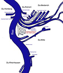
The Meiderich lock is located parallel to it in the Rhine-Herne Canal (RHK abbreviation) . Both locks are simply designed and together handle traffic from the RHK, the Ruhr and the Ruhrschifffahrtskanal (RSK) in and from the Rhine. This works because a few hundred meters upstream behind the two locks of the RHK and the Ruhr (or the RSK) are connected without a barrage.
lock
The system, which is remote-controlled from the Duisburg-Meiderich lock, has a usable length of 311.00 meters and a usable width of 12.80 meters. It is designed for the inland waterway of class Vb for the large Rhine ship in push convoy . Both the Rhine-Herne Canal and the Rhine-Ruhr Harbor can be reached via them (via RSK with the Ruhr lock Raffelberg ).
The Ruhr lock is used by around 9,000 ships every year.
Waterway network
Locks made the Ruhr navigable to Fröndenberg-Langschede for navigation on the Ruhr at the end of the 18th century . At times the river was the busiest waterway in Europe. However, commercial shipping on the Ruhr ended with the advent of the railroad in the mid-19th century.
To increase its economic power, the city of Mülheim decided to build a port and create a direct connection to the port of Duisburg. In addition, the Ruhr was given a new bed between the ports, as the original Ruhr route was unsuitable for the large Rhine ships. The construction time was twelve years from 1942 to 1956. The gradient of around ten meters between the cities was compensated by two new locks.
The Rhine-Ruhr port in Mülheim an der Ruhr is approached via the Ruhr shipping canal, because here the Ruhr runs in wide loops that are unsuitable for inland shipping.
The Rhine-Herne Canal (RHK) branches off to the north at the canal port. It can be used to reach the Waltrop lock park , where the Rhine-Herne Canal ends and merges into the Dortmund-Ems Canal . It continues north or through the lock as a branch canal to the south-east into the port of Dortmund . The canal triangle in Datteln can be reached via the DEK to the north, where the Datteln-Hamm Canal (DHK) branches off to the east and, a little further north, the Wesel-Datteln Canal to the northwest.
The Duisburg-Ruhrort ports in the Ruhrort district are located between the Meiderich lock and the Rhine.


