
Rhine-Herne Canal
| Rhine-Herne Canal | |||||||||||||||||||||||||||||||||||||||||||||||||||||||||||||||||||||||||||||||||||||||||||||||||||||||||||||||||||||||||||||||||||||||||||||||||||||||||||||||||||||||||||||||||||||||||||||||||||||||||||||||||||||||||||||||||||||||||||||||||||||||||||||||||||||||||||||||||||||||||||||||||||||||||||||||||||||||||||||||||||||||||||||||||||||||||||||||||||||||||||||||||||||||||||||||||||||||||||||||||||||||||||||||||||||||||||||||||||||||||||||||||||||||||||||||||||||||||||||||||||||||||||||||||||||||||||||||||||||||||||||||||||||||||||||||||||||||||||||
|---|---|---|---|---|---|---|---|---|---|---|---|---|---|---|---|---|---|---|---|---|---|---|---|---|---|---|---|---|---|---|---|---|---|---|---|---|---|---|---|---|---|---|---|---|---|---|---|---|---|---|---|---|---|---|---|---|---|---|---|---|---|---|---|---|---|---|---|---|---|---|---|---|---|---|---|---|---|---|---|---|---|---|---|---|---|---|---|---|---|---|---|---|---|---|---|---|---|---|---|---|---|---|---|---|---|---|---|---|---|---|---|---|---|---|---|---|---|---|---|---|---|---|---|---|---|---|---|---|---|---|---|---|---|---|---|---|---|---|---|---|---|---|---|---|---|---|---|---|---|---|---|---|---|---|---|---|---|---|---|---|---|---|---|---|---|---|---|---|---|---|---|---|---|---|---|---|---|---|---|---|---|---|---|---|---|---|---|---|---|---|---|---|---|---|---|---|---|---|---|---|---|---|---|---|---|---|---|---|---|---|---|---|---|---|---|---|---|---|---|---|---|---|---|---|---|---|---|---|---|---|---|---|---|---|---|---|---|---|---|---|---|---|---|---|---|---|---|---|---|---|---|---|---|---|---|---|---|---|---|---|---|---|---|---|---|---|---|---|---|---|---|---|---|---|---|---|---|---|---|---|---|---|---|---|---|---|---|---|---|---|---|---|---|---|---|---|---|---|---|---|---|---|---|---|---|---|---|---|---|---|---|---|---|---|---|---|---|---|---|---|---|---|---|---|---|---|---|---|---|---|---|---|---|---|---|---|---|---|---|---|---|---|---|---|---|---|---|---|---|---|---|---|---|---|---|---|---|---|---|---|---|---|---|---|---|---|---|---|---|---|---|---|---|---|---|---|---|---|---|---|---|---|---|---|---|---|---|---|---|---|---|---|---|---|---|---|---|---|---|---|---|---|---|---|---|---|---|---|---|---|---|---|---|---|---|---|---|---|---|---|---|---|---|---|---|---|---|---|---|---|---|---|---|---|---|---|---|---|---|---|---|---|---|---|---|---|---|---|---|---|---|---|---|---|---|---|---|---|---|---|---|---|---|---|---|---|---|---|---|---|---|---|---|---|---|---|---|---|---|---|---|---|---|---|---|---|---|---|---|---|---|---|---|---|---|---|---|---|---|---|---|---|---|---|---|---|---|---|---|---|---|---|---|---|---|---|---|---|---|---|---|---|---|---|---|---|---|---|---|---|---|---|---|---|---|---|---|---|---|---|---|---|---|---|---|---|---|---|---|---|---|---|---|---|---|---|---|
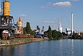
 View from the gasometer to the Rhine-Herne Canal near Oberhausen , to the left of it the Emscher and further left the Autobahn 42 (Emscher Schnellweg ), to the right of the canal parts of the CentrO |
|||||||||||||||||||||||||||||||||||||||||||||||||||||||||||||||||||||||||||||||||||||||||||||||||||||||||||||||||||||||||||||||||||||||||||||||||||||||||||||||||||||||||||||||||||||||||||||||||||||||||||||||||||||||||||||||||||||||||||||||||||||||||||||||||||||||||||||||||||||||||||||||||||||||||||||||||||||||||||||||||||||||||||||||||||||||||||||||||||||||||||||||||||||||||||||||||||||||||||||||||||||||||||||||||||||||||||||||||||||||||||||||||||||||||||||||||||||||||||||||||||||||||||||||||||||||||||||||||||||||||||||||||||||||||||||||||||||||||||||
| abbreviation | RHK | ||||||||||||||||||||||||||||||||||||||||||||||||||||||||||||||||||||||||||||||||||||||||||||||||||||||||||||||||||||||||||||||||||||||||||||||||||||||||||||||||||||||||||||||||||||||||||||||||||||||||||||||||||||||||||||||||||||||||||||||||||||||||||||||||||||||||||||||||||||||||||||||||||||||||||||||||||||||||||||||||||||||||||||||||||||||||||||||||||||||||||||||||||||||||||||||||||||||||||||||||||||||||||||||||||||||||||||||||||||||||||||||||||||||||||||||||||||||||||||||||||||||||||||||||||||||||||||||||||||||||||||||||||||||||||||||||||||||||||||
| location | Germany : North Rhine-Westphalia | ||||||||||||||||||||||||||||||||||||||||||||||||||||||||||||||||||||||||||||||||||||||||||||||||||||||||||||||||||||||||||||||||||||||||||||||||||||||||||||||||||||||||||||||||||||||||||||||||||||||||||||||||||||||||||||||||||||||||||||||||||||||||||||||||||||||||||||||||||||||||||||||||||||||||||||||||||||||||||||||||||||||||||||||||||||||||||||||||||||||||||||||||||||||||||||||||||||||||||||||||||||||||||||||||||||||||||||||||||||||||||||||||||||||||||||||||||||||||||||||||||||||||||||||||||||||||||||||||||||||||||||||||||||||||||||||||||||||||||||
| length | 45.4 km | ||||||||||||||||||||||||||||||||||||||||||||||||||||||||||||||||||||||||||||||||||||||||||||||||||||||||||||||||||||||||||||||||||||||||||||||||||||||||||||||||||||||||||||||||||||||||||||||||||||||||||||||||||||||||||||||||||||||||||||||||||||||||||||||||||||||||||||||||||||||||||||||||||||||||||||||||||||||||||||||||||||||||||||||||||||||||||||||||||||||||||||||||||||||||||||||||||||||||||||||||||||||||||||||||||||||||||||||||||||||||||||||||||||||||||||||||||||||||||||||||||||||||||||||||||||||||||||||||||||||||||||||||||||||||||||||||||||||||||||
| Built | 1906-1914 | ||||||||||||||||||||||||||||||||||||||||||||||||||||||||||||||||||||||||||||||||||||||||||||||||||||||||||||||||||||||||||||||||||||||||||||||||||||||||||||||||||||||||||||||||||||||||||||||||||||||||||||||||||||||||||||||||||||||||||||||||||||||||||||||||||||||||||||||||||||||||||||||||||||||||||||||||||||||||||||||||||||||||||||||||||||||||||||||||||||||||||||||||||||||||||||||||||||||||||||||||||||||||||||||||||||||||||||||||||||||||||||||||||||||||||||||||||||||||||||||||||||||||||||||||||||||||||||||||||||||||||||||||||||||||||||||||||||||||||||
| Expanded | 1968–1995, since 2010 | ||||||||||||||||||||||||||||||||||||||||||||||||||||||||||||||||||||||||||||||||||||||||||||||||||||||||||||||||||||||||||||||||||||||||||||||||||||||||||||||||||||||||||||||||||||||||||||||||||||||||||||||||||||||||||||||||||||||||||||||||||||||||||||||||||||||||||||||||||||||||||||||||||||||||||||||||||||||||||||||||||||||||||||||||||||||||||||||||||||||||||||||||||||||||||||||||||||||||||||||||||||||||||||||||||||||||||||||||||||||||||||||||||||||||||||||||||||||||||||||||||||||||||||||||||||||||||||||||||||||||||||||||||||||||||||||||||||||||||||
| class | Vb (km 0.16-39.96), IV (km 39.97-45.60) |
||||||||||||||||||||||||||||||||||||||||||||||||||||||||||||||||||||||||||||||||||||||||||||||||||||||||||||||||||||||||||||||||||||||||||||||||||||||||||||||||||||||||||||||||||||||||||||||||||||||||||||||||||||||||||||||||||||||||||||||||||||||||||||||||||||||||||||||||||||||||||||||||||||||||||||||||||||||||||||||||||||||||||||||||||||||||||||||||||||||||||||||||||||||||||||||||||||||||||||||||||||||||||||||||||||||||||||||||||||||||||||||||||||||||||||||||||||||||||||||||||||||||||||||||||||||||||||||||||||||||||||||||||||||||||||||||||||||||||||
| Beginning | Branch from basin C of the Duisburg-Ruhrorter ports | ||||||||||||||||||||||||||||||||||||||||||||||||||||||||||||||||||||||||||||||||||||||||||||||||||||||||||||||||||||||||||||||||||||||||||||||||||||||||||||||||||||||||||||||||||||||||||||||||||||||||||||||||||||||||||||||||||||||||||||||||||||||||||||||||||||||||||||||||||||||||||||||||||||||||||||||||||||||||||||||||||||||||||||||||||||||||||||||||||||||||||||||||||||||||||||||||||||||||||||||||||||||||||||||||||||||||||||||||||||||||||||||||||||||||||||||||||||||||||||||||||||||||||||||||||||||||||||||||||||||||||||||||||||||||||||||||||||||||||||
| The End | Estuary Dortmund-Ems Canal near Henrichenburg | ||||||||||||||||||||||||||||||||||||||||||||||||||||||||||||||||||||||||||||||||||||||||||||||||||||||||||||||||||||||||||||||||||||||||||||||||||||||||||||||||||||||||||||||||||||||||||||||||||||||||||||||||||||||||||||||||||||||||||||||||||||||||||||||||||||||||||||||||||||||||||||||||||||||||||||||||||||||||||||||||||||||||||||||||||||||||||||||||||||||||||||||||||||||||||||||||||||||||||||||||||||||||||||||||||||||||||||||||||||||||||||||||||||||||||||||||||||||||||||||||||||||||||||||||||||||||||||||||||||||||||||||||||||||||||||||||||||||||||||
| Descent structures | Meiderich , Oberhausen , Gelsenkirchen , Wanne-Eickel , Herne-Ost | ||||||||||||||||||||||||||||||||||||||||||||||||||||||||||||||||||||||||||||||||||||||||||||||||||||||||||||||||||||||||||||||||||||||||||||||||||||||||||||||||||||||||||||||||||||||||||||||||||||||||||||||||||||||||||||||||||||||||||||||||||||||||||||||||||||||||||||||||||||||||||||||||||||||||||||||||||||||||||||||||||||||||||||||||||||||||||||||||||||||||||||||||||||||||||||||||||||||||||||||||||||||||||||||||||||||||||||||||||||||||||||||||||||||||||||||||||||||||||||||||||||||||||||||||||||||||||||||||||||||||||||||||||||||||||||||||||||||||||||
| Ports | Duisburg canal port, Rütgers factory port, Heinz-Schleußer-Marina , Bottrop, Essen city port, BP Gelsenkirchen, Gelsenkirchen city port , Hugo, Grimberg, Wanne west port, Wanne east port, Julia, Recklinghausen city port, WSV construction port, Herne base port, King Ludwig, Friedrich der Große, Victor, Rütgers, Luck, Knauf / Marmorit, outer port of the old Henrichenburg lift | ||||||||||||||||||||||||||||||||||||||||||||||||||||||||||||||||||||||||||||||||||||||||||||||||||||||||||||||||||||||||||||||||||||||||||||||||||||||||||||||||||||||||||||||||||||||||||||||||||||||||||||||||||||||||||||||||||||||||||||||||||||||||||||||||||||||||||||||||||||||||||||||||||||||||||||||||||||||||||||||||||||||||||||||||||||||||||||||||||||||||||||||||||||||||||||||||||||||||||||||||||||||||||||||||||||||||||||||||||||||||||||||||||||||||||||||||||||||||||||||||||||||||||||||||||||||||||||||||||||||||||||||||||||||||||||||||||||||||||||
| Junctions, crossings | Connection channel to the Ruhr | ||||||||||||||||||||||||||||||||||||||||||||||||||||||||||||||||||||||||||||||||||||||||||||||||||||||||||||||||||||||||||||||||||||||||||||||||||||||||||||||||||||||||||||||||||||||||||||||||||||||||||||||||||||||||||||||||||||||||||||||||||||||||||||||||||||||||||||||||||||||||||||||||||||||||||||||||||||||||||||||||||||||||||||||||||||||||||||||||||||||||||||||||||||||||||||||||||||||||||||||||||||||||||||||||||||||||||||||||||||||||||||||||||||||||||||||||||||||||||||||||||||||||||||||||||||||||||||||||||||||||||||||||||||||||||||||||||||||||||||
| Kilometrage | towards the east, ascending from km 0.16 to km 45.60 | ||||||||||||||||||||||||||||||||||||||||||||||||||||||||||||||||||||||||||||||||||||||||||||||||||||||||||||||||||||||||||||||||||||||||||||||||||||||||||||||||||||||||||||||||||||||||||||||||||||||||||||||||||||||||||||||||||||||||||||||||||||||||||||||||||||||||||||||||||||||||||||||||||||||||||||||||||||||||||||||||||||||||||||||||||||||||||||||||||||||||||||||||||||||||||||||||||||||||||||||||||||||||||||||||||||||||||||||||||||||||||||||||||||||||||||||||||||||||||||||||||||||||||||||||||||||||||||||||||||||||||||||||||||||||||||||||||||||||||||
| Downhill | To the west | ||||||||||||||||||||||||||||||||||||||||||||||||||||||||||||||||||||||||||||||||||||||||||||||||||||||||||||||||||||||||||||||||||||||||||||||||||||||||||||||||||||||||||||||||||||||||||||||||||||||||||||||||||||||||||||||||||||||||||||||||||||||||||||||||||||||||||||||||||||||||||||||||||||||||||||||||||||||||||||||||||||||||||||||||||||||||||||||||||||||||||||||||||||||||||||||||||||||||||||||||||||||||||||||||||||||||||||||||||||||||||||||||||||||||||||||||||||||||||||||||||||||||||||||||||||||||||||||||||||||||||||||||||||||||||||||||||||||||||||
| Responsible WSD | Waterways and Shipping Office Duisburg-Meiderich | ||||||||||||||||||||||||||||||||||||||||||||||||||||||||||||||||||||||||||||||||||||||||||||||||||||||||||||||||||||||||||||||||||||||||||||||||||||||||||||||||||||||||||||||||||||||||||||||||||||||||||||||||||||||||||||||||||||||||||||||||||||||||||||||||||||||||||||||||||||||||||||||||||||||||||||||||||||||||||||||||||||||||||||||||||||||||||||||||||||||||||||||||||||||||||||||||||||||||||||||||||||||||||||||||||||||||||||||||||||||||||||||||||||||||||||||||||||||||||||||||||||||||||||||||||||||||||||||||||||||||||||||||||||||||||||||||||||||||||||
| The Rhine-Herne Canal is an artificially created canal and is between four and six meters deep | |||||||||||||||||||||||||||||||||||||||||||||||||||||||||||||||||||||||||||||||||||||||||||||||||||||||||||||||||||||||||||||||||||||||||||||||||||||||||||||||||||||||||||||||||||||||||||||||||||||||||||||||||||||||||||||||||||||||||||||||||||||||||||||||||||||||||||||||||||||||||||||||||||||||||||||||||||||||||||||||||||||||||||||||||||||||||||||||||||||||||||||||||||||||||||||||||||||||||||||||||||||||||||||||||||||||||||||||||||||||||||||||||||||||||||||||||||||||||||||||||||||||||||||||||||||||||||||||||||||||||||||||||||||||||||||||||||||||||||||
 (in the background: the Oberhausen gasometer) |
|||||||||||||||||||||||||||||||||||||||||||||||||||||||||||||||||||||||||||||||||||||||||||||||||||||||||||||||||||||||||||||||||||||||||||||||||||||||||||||||||||||||||||||||||||||||||||||||||||||||||||||||||||||||||||||||||||||||||||||||||||||||||||||||||||||||||||||||||||||||||||||||||||||||||||||||||||||||||||||||||||||||||||||||||||||||||||||||||||||||||||||||||||||||||||||||||||||||||||||||||||||||||||||||||||||||||||||||||||||||||||||||||||||||||||||||||||||||||||||||||||||||||||||||||||||||||||||||||||||||||||||||||||||||||||||||||||||||||||||
|
course
|
|||||||||||||||||||||||||||||||||||||||||||||||||||||||||||||||||||||||||||||||||||||||||||||||||||||||||||||||||||||||||||||||||||||||||||||||||||||||||||||||||||||||||||||||||||||||||||||||||||||||||||||||||||||||||||||||||||||||||||||||||||||||||||||||||||||||||||||||||||||||||||||||||||||||||||||||||||||||||||||||||||||||||||||||||||||||||||||||||||||||||||||||||||||||||||||||||||||||||||||||||||||||||||||||||||||||||||||||||||||||||||||||||||||||||||||||||||||||||||||||||||||||||||||||||||||||||||||||||||||||||||||||||||||||||||||||||||||||||||||


The Rhine-Herne Canal (RHK, water code: 74001) is a 45.4 kilometer long federal waterway in the Ruhr area , North Rhine-Westphalia , with five canal levels today. It is administered by the Duisburg-Meiderich Waterways and Shipping Office.
course

The Rhine-Herne Canal leads from the Rhine to the Dortmund-Ems Canal . It branches off from the Duisburg port canal at basin C at canal kilometer 0.16 and connects the Duisburg-Ruhrort ports with the western German canal network . The connecting canal to the Ruhr branches off at canal kilometer 1.4 . From Oberhausen , the canal follows the straightened Emscher to the south and largely parallel to it . A conceivable naming similar to the Lippe side canal as the "Emscher side canal" was common in the planning phase.
history
The construction of the canal from April 5, 1906 to July 17, 1914 took over eight years and cost around 60 million German marks . It was headed by the Royal Canal Construction Directorate in Essen, which was founded in 1906 . The geomorphological conditions of the Emschertal were largely used for the construction . Partly, especially in Herne and Gelsenkirchen , the canal was laid in the former Emscher river bed , the course of which had shifted slightly to the north due to the previous straightening .
The industrialist William Thomas Mulvany had already presented plans to expand the Emscher itself into a shipping lane, known as the Emscher Canal , in Düsseldorf in the second half of the 19th century . In Essen 1873 was Emscher canal committee was established. Initially, the plans to channel the Emscher were pursued further. The technical feasibility was presented by the committee in 1875. In the further planning, the canalization of the lower Emscher was retained, further east a side canal was planned south of the river, up to the confluence with the already completed Dortmund-Ems canal. This projected waterway from Laar am Rhein to Herne, mainly known as the Dortmund-Rhine Canal, was also called the Emscherthal Canal . The legal basis for the construction of the Rhine-Herne Canal from Ruhrort to Herne was ultimately the law passed by the Prussian king on the construction and expansion of waterways of April 1, 1905.
In 1914 the Rhine-Herne Canal was completed with initially seven canal steps. It was built for ships up to 1350 tons. Ships of this carrying capacity, which correspond to the dimensions of the original locks on the canal, are therefore called Rhine-Herne Canal ships . The canal counts from the Duisburg-Ruhrorter ports up to 5.6 km before its transition to the Dortmund-Ems Canal to waterway class Vb, on the remainder to class IV.
The first ship to sail the Canal on July 17, 1914, was the Tyd is Geld barge .
In the case of the canal profile and in all structures, options have been provided to compensate for subsidence, as it actually became necessary later to a larger extent.
The Rhine-Herne Canal originally ended in Herne, where it met the branch canal of the Dortmund-Ems Canal from Henrichenburg to Herne above the Herne-Ost lock . With the closure of the last part of the branch canal, the section from the canal port of the Friedrich der Große Colliery , Annex 3/4 to the end in front of Bahnhofstrasse, the Henrichenburg – Herne section was added to the Rhine-Herne Canal in 1950. On the disused and drained section of the canal east of the bridge over the Bahnhofstrasse to the bridge over the Landwehrbach in Herne, the federal motorway 42 (Emscherschnellweg) now runs .
During the expansion of the route between Duisburg-Meiderich and Wanne-Eickel between 1968 and 1995, bottlenecks were eliminated, curves flattened and bridges raised. For bank protection, sheet pile walls and slope extensions alternated. Expansion work has been taking place in the area of the port of Grimberg up to the Wanne-Eickel lock since 2010. The canal is also to be deepened and widened above the Herne-Ost lock. The largest construction site is the new construction of the Emscher pass . Some bridges also have to be rebuilt with a larger span.
As part of the Ruhr.2010 Capital of Culture year in the Ruhr area, the Rhine-Herne Canal was included in numerous cultural events, the main project being the KulturKanal , which was continued in 2011.
Drainage
The Rhine-Herne Canal (RHK) is a member of the water pipeline network that is formed from the West German canals canals (Datteln - Hamm, Dortmund - Ems, Rhine - Herne and Wesel - Datteln). This network is not only used for shipping for the locks and to compensate for seepage and evaporation, but also to a large extent for public, agricultural and industrial water supply in the form of service water (cooling water for power plants ) and consumption water . The demand is covered on the one hand by withdrawal from the upper lip at the Hamm water transfer , and also by the connecting canal to the lower reaches of the Ruhr from the Ruhr and in exceptional cases from the Rhine . On the other hand, by pumping back lock water, consumption for shipping is minimized. For this purpose, the RHK was equipped from 1958-1965 by means of its own pumping station chain with a return pumping station at each canal step. The RHK had its own water available and no longer had to be supplied via the Wesel-Datteln Canal and the Herne-Ost lock. The first pumping stations had to be replaced between 1980 and 1994 due to the construction of new locks; at the same time, a switch was made to more powerful units. The entire water supply for the West German canals has been coordinated by the remote control center in Datteln since 1984.
Locks


The locks are used to overcome the height difference between the Rhine and the Herne - Münster apex position of the Dortmund-Ems Canal of 31.5 m plus the height of fall at the entrance lock depending on the Rhine water level.
Duisburg-Meiderich lock
Main article → Meiderich lock
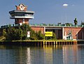
In 1980 the current lock was completed at canal kilometer 0.82. It is the entrance lock of the canal, whose 24 m high lower gate with the control stand sets a yellow landmark visible from afar in the harbor and Ruhr landscape. Their lower head was adapted to the lowered Rhine water levels. The outer harbor of the old lock can still be seen in the underwater by the walls of the canal. As a reserve space for a possibly necessary new construction of the lock, it will not be filled.
The predecessor of today's lock was put into operation when the canal was opened in 1914.
Instead of the old 165 m long and 10 m wide lock chamber, the new chamber has a usable length of 190 m and a width of 12 m; therefore, large push convoys can also pass through the lock with Europe class II barges.
The height of fall depends on the Rhine water level. When the Rhine floods, the water level towards the Rhine can even be higher than in the canal, so that the canal does not have to be channeled uphill, as usual, but down into the valley. The lock does not have its own pumping station, but the pumps in harbor basin C of the Ruhrorter Hafen ensure that the water is pumped back into the canal.
The lock can be operated by one person. Here at the beginning of the canal is the lifting point for the usage fees, the incoming and outgoing ships are registered. The Ruhr locks in Duisburg and Raffelberg are also controlled from here . Around 19,000 ships with a total of 15 million tons of cargo passed the Meiderich lock in 2010.
The canal step was equipped with only one lock, as the nearby Ruhr lock Duisburg can take over the function of a second .
Oberhausen lock group
Main article → Oberhausen lock group
The Oberhausen lock group is located at kilometer 5.68. Today's canal step bridges a height difference of 4.1 m and has two locks. The southern lock was built between 1977 and 1979 and has a usable length of 190 m and a usable width of 11.99 m. The northern lock was completed on July 28, 1984 after two years of construction and has a useful length of 190 m and a useful width of 11.88 m.
Former Essen-Dellwig lock group
The third stage of the Rhine-Herne Canal was located in the Essen district of Dellwig with two locks, as on all stages of the canal except Duisburg-Meiderich. Each lock was 165 m long and 10 m wide. The locks were closed with folding gates in the head and sliding gates in the lower head. The Dellwig stage was abandoned in 1980 due to subsidence.
Gelsenkirchen lock group
Main article → Gelsenkirchen lock group
The Gelsenkirchen lock is located at kilometer 23.32 of the canal and bridges a height difference of 6.2 m. The current lock group was built between 1980 and 1985 and consists of two locks. Both have a usable length of 190 m. The north lock is designed for a usable width of 12.1 m, the usable width of the south lock is 11.94 m. Both locks have lifting gates on the upstream side and stemmed gates on the downstream side . It takes 55 seconds to open the upper gate and only 35 seconds to open the lower gate.
Wanne-Eickel lock group
Main article: Wanne-Eickel lock group
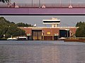
The Wanne-Eickel lock group is located at canal kilometer 31.20 and bridges a fall height of 8.4 m. This system also consists of two locks, with only the south lock being newly built and geared to the needs of today's inland shipping.
Both locks were built when the canal was built between 1906 and 1914 and had a usable length of 165 m and a width of 10 m. In the lock chambers there was room for two of the predominant ship types at that time, which were 80 m long, 9.5 m wide and 2.5 m draft . Today the Nordschleuse has been preserved in its original size, although it is currently not in use. It would also be too small for ships in European class II .
The south lock was rebuilt in 1994 and has a usable length of 190 m and a width of 12 m. The rebuilding of the Nordschleuse is planned.
The Wanne-Eickel lock group is a stop on two themed routes on the Route of Industrial Culture : Erzbahn-Emscherbruch and canals and shipping .
On the left the quay wall and loading facilities of the Wanne-Herner railway and port , behind it the northern lock
The new southern lock from underwater, with the control room for controlling the system

The disused northern lock with the frame for guiding the lifting gate to the underwater

Headwater of the plant, right freighters with wood chips in the background the coal power plant of STEAG


Former lock group Herne-West
The former Herne-West lock group at canal kilometer 35.25 was replaced when the Herne-East lock system was renewed and removed in 1991. For this purpose, the canal was deepened by 4.5 m in the section from Herne-West to Herne-Ost and the water level was lowered to that of the Wanne-Eickel section.
The old lock was no longer sufficient in length and width for the dimensions of modern ships and push convoys. The fabric of the building itself was outdated and severely damaged by subsidence . In the course of the dismantling of the locks, the outer walls of both lock chambers have been preserved. The measures to compensate for the subsidence can still be clearly seen on the southern wall in particular. The chamber wall had to be raised by 80 cm at the western end, but by 3.5 m at the eastern end. This can be seen in the panorama picture by the difference between brickwork and reinforced concrete elevation.
These locks are about to leap into seconds . This was known when the canal was planned, but it was assumed that subsidence would not take place here in particular, as no hard coal was to be mined in the jump area.

Lock Herne-Ost
Main article: Herne-Ost lock
The lock system Herne-Ost at canal kilometer 37.26 was renewed as a twin lock between 1986 and 1992 . The new lock chambers are each 190 m long and 12 m wide. The jamb depth (water depth at the upper gate) is 4 m. A rotating segment gate forms the end to the upper water . Stem gates close the chambers to the underwater. The difference between the upper and lower water is 12.8 m. A lock takes around 14 minutes - not counting the entry and exit times of the ships. The two lock chambers are connected in such a way that the draining water from one chamber can be used to fill the other until there is a tie. The second half of the water is then drained into the underwater and the other, half-full chamber is filled from the upper water. In this way, the water consumption per lock is halved. Since a canal is a stagnant body of water and not a river, the loss of water from the upstream water during locks has to be compensated for by pumping back.
Lock Herne-Ost

Lock Herne-Ost,
upper water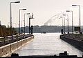
Lock Herne-Ost,
lock chamber
Lock Herne-Ost,
view of the underwater
.jpg)
.jpg)
.jpg)
.jpg)
To the pictures in the gallery:
The left picture shows the lock system from underwater, the outer harbor, which is used by waiting ships, the lock system with the two lower gates and the steering position, which is similar to an airport tower. The chambers are structures made of reinforced concrete with a clinker finish on the visible side. The gate of the southern chamber is open. The outgoing motor ship “Carina” comes from Děčín in the Czech Republic . The difference in water level in the chamber can be estimated from the damp algae growth on the left wall of the chamber (12.8 m). At the top of the picture the bridge of Horsthauser Strasse over the canal. On the right bank there are several anglers who like to use the abundance of fish in the area of the lock system.
The picture from the upper water shows the southern chamber on the left with the upper gate. The northern chamber (right) is open to the exit. To open, this gate is sunk against the headwater around an axis just above the jamb . The entry and exit of the ships is regulated by traffic lights. The lock master can remotely control the entire system by himself, as television cameras are installed at all important points. In the chamber on the right: Motor ship Aurora before the exit.
The third picture shows the chamber open to the headwater after the exit of the second ship of the observed lock passage - motor ship Bydgoszcz from Poland .
The right picture shows the course of the canal to the west, in front the outer harbor, the road bridge mentioned above, then a grain mill and its silo systems in the Recklinghausen area, to the left of it and approx. 5 km away the STEAG hard coal-fired power plant in the Herne district of Baukau . Both banks of the canal are lined with paved paths which are often used by walkers and cyclists.

Ports
Rütgers factory port in Duisburg
The Rütgers factory harbor is used for tanker shipping. It is located at canal kilometer 4.25 on the northern bank of the canal west of the abutment of the former bridge in the course of Gartroper Straße.

Heinz Schleusser Marina in Oberhausen
The Heinz Schleusser Marina is a sport boat harbor that was opened in 2004 and is a short distance from the CentrO . The port has a water depth of 2.5 meters and 13 jetties with 60 berths. The Sea Life Oberhausen , the Lego Discovery Center Oberhausen and the Aquapark leisure pool are located directly at the marina . Pirates and treasures have also been in the marina since June 2015.

King Wilhelm oil port
The oil loading port is located in Essen-Dellwig between 14.35 and 14.68 canal kilometers. It is used by Green Power Oil , based in Bremerhaven , a manufacturer and marketer of vegetable oils and by-products and by-products with a tank farm just south of the port facilities.

Bottrop harbor
The city port of Bottrop was built in 1914 and operated for a long time by the port and railway operations of Ruhrkohle AG . After its connection to the colliery railways in the northern Ruhr area had lost its importance due to the colliery closings, it developed into a transshipment point for heating oil, diesel, cyclohexane, methanol and xylene. The operator is Ruhr Oel GmbH , which also owns the tank farm there. The port area is divided into two areas: Port I has a quay length of 90 meters with two transshipment points, Port II has a length of 320 meters and four transshipment points. At the eastern end of the port, opposite the city port of Essen and directly at the bridge of the A 42, is the berth of the Marinekameradschaft Bottrop.

Essen city harbor
The city port of Essen was the youngest port on the Rhine-Herne Canal and was commissioned by the city of Essen in 1934 and has been operated by the Essen municipal utilities since 1987 . The port consists of a pier basin at a straight angle to the canal and a parallel port along the canal, which together have a water surface of 63,000 m². The most important goods handled are solid and mineral fuels, mineral oil and chemical products, stone and earth as well as iron and steel.

Mathias Stinnes harbor
The port of the former Mathias Stinnes colliery is located on the north bank of the canal. It lost its function with its closure. All technical systems were dismantled, only the quay wall remained. The port area is used by anglers. In the picture on the right the chimney of the RWE waste incineration plant Essen-Karnap , the (smaller) chimney further to the left belongs to the Bottrop sewage treatment plant .


Port of the BP Gelsenkirchen GmbH
The refinery port of BP Gelsenkirchen GmbH is divided into two parts with a western basin parallel to and open to the canal, with four berths on the quay wall and an eastern port basin for two ships. A compressed air oil barrier is active while refinery products are being loaded onto tankers . A third of the total production of the plant is shipped via this port with four million tons. Fuels have the largest share in this.


Gas tanks on the south side in the industrial port
|

Gelsenkirchen city harbor
The city port of Gelsenkirchen was opened in July 1914, making it the oldest port on the Rhine-Herne Canal. The port branches off as a spur port with two port basins at the upper outer port of the Gelsenkirchen lock and has a water surface of 117,800 m². The operating company is Gelsenkirchener Hafenbetriebsgesellschaft mbH , a subsidiary of Stadtwerke Gelsenkirchen . The port is divided into an industrial port and a commercial port. In addition to other goods, primarily mineral oil and steel products as well as malt and grain are handled in the port of Gelsenkirchen. The port's turnover is 1.2 million tons per year.

Hugo port
The port of the former Hugo colliery consists of a port basin open towards the canal, which is separated at the rear by a sheet pile wall. The former port facilities have been completely removed. In the background you can see one of the construction sites for the new Emscher Canal .

Graf Bismarck harbor
At the port of the former Graf Bismarck colliery, the railway bridge spanning the access has been replaced by a pedestrian and cycle path bridge. The cleared colliery site is currently being built with a settlement of single and multi-family houses. Local companies have set up shop to the west of the port. On the waterfront, in the office complex called Stölting Harbor, restaurants and a club have also settled. The group also operates the Marina the harbor.


Grimberg harbor
The port of Grimberg is located on the southern bank of the canal in Gelsenkirchen , near the city limits of Herne . It was named after the nearby Grimberg Castle , of which only the foundation walls are known today. A major factor in the construction of the port, as harbor master, was Wilhelm Bernard Wilting, who lived in Grimberg Castle with his family at the time and whose descendants still live in Gelsenkirchen today (as of 2019). The port was primarily used to land ore to supply the ironworks in Bochum and Gelsenkirchen. This is where the ore railway (Bochum) began . With the shutdown of the iron and steel works, it lost its original function. Today it is used by building materials and recycling companies to process and ship their products.
The Grimberger sickle was built between the port and the zoo to connect the route on the ore railway line to the network of roads north of the canal . The official inauguration of the bridge took place during a ceremony on October 26, 2008.
Westhafen tub
After the harbor basin of the Wanner Westhafen was filled in to make space for the Emscher freight center, the Westhafen only consists of a quay wall with loading facilities for bulk goods such as coal and z. B. sand. It is operated by the Wanne-Herner Eisenbahn und Hafen .

East Harbor Tub
The east port, like the west port, is operated by the Wanne-Herner Eisenbahn und Hafen GmbH . Here scrap is an important cargo.


Recklinghausen city harbor
Originally, the city of Recklinghausen had no access to the canal, as the city limits in the south largely followed the course of the Emscher . It was only through the acquisition of territory by the city of Herne that it became possible to build the city port of Recklinghausen on urban territory. After initial profitability, the port was given up a few years ago. Only an old harbor crane still attested to its earlier function. Both commercial and leisure activities have developed in recent years thanks to new funding projects.

Construction port of the Federal Waterways and Shipping Administration
The Herne construction port of the Duisburg-Meiderich waterways and shipping authority was rebuilt here in the course of deepening the canal. It is used by the water and shipping administration to maintain the canal with its locks and pumping stations in the area from Essen to Herne. Maintenance and repair work is carried out from here.

Port of Frederick the Great
The port of Frederick the Great was originally used to load coal from the mine of the same name and to load steel parts from the Peiner Stahlhandel, located on the edge of the mine site (the mine was temporarily owned by the Ilseder Hütte in Peine). Up until 2008 there was still a siding on the quay wall , which is no longer used after the colliery was closed. The rails have been removed and the area is now used as a parking lot for trucks. To the east of the harbor basin, a steel trading company has settled on the industrial site "Friedrich der Große", which uses the canal for its logistics with a covered loading facility regardless of the weather. The port is part of the Herner Sea , which also includes the mooring and yachting port, the Schleusenvorhafen and the port of the former König Ludwig colliery, which is now also used as a yachting port . According to information from a drilling team engaged in basic investigations, the deepest point of the canal is around nine meters in the area of the Herner Meer.

King Ludwig harbor
The port was used to sell coal, but also to deliver materials to the former König Ludwig colliery . It is located at canal kilometer 38 on the upper water of the Herne-Ost lock, on the north side opposite the port of the Friedrich der Große colliery . The 1.7 hectare harbor basin was laid out from December 1897 to 1898, when the section of the canal (at that time a branch canal of the Dortmund-Ems canal) was already flooded. In 1912, 360,096 t of goods were handled at the Zechenhafen. In 1913 the harbor basin was expanded. Due to subsidence , the quay wall had to be raised by 2.5 m in 1954. In the 1980s, the Automobil- und Motorbootsport-Club Castrop-Rauxel e. V. took over the no longer used port area from Ruhrkohle AG and has since operated it as a landing stage for pleasure craft.
The König-Ludwig-Trasse, a former works railway line that has been converted into a pedestrian and cycle path, begins at the harbor. It connected the eponymous King Ludwig colliery with the port.

Port Victor
The port of Victor was created as the factory port of the former Zeche Victor . The port is located in the urban area of Castrop-Rauxel near Bladenhorst Castle . The port is still used today for coal handling, which is handled with the help of two gantry cranes.

Port of Ruetgers
The port of the Rütgerswerke Rütgers Chemicals (founded by Julius Rütgers ) is not far from the port of Victor on the east side of the canal, which makes a slight bend to the north here. The Rütgerswerke deal with tar chemistry. The main product in terms of quantity is pitch from coal tar . The port has a compressed air oil barrier .

Luck Harbor
The port of Luck belongs to the construction and building materials company Luck.

Port Knauf / Marmorit
The port of the building materials manufacturer Knauf Marmorit GmbH is more of a landing stage than a whole port. It is located on the north side of the canal arm east of the bridge on Wartburgstrasse in Castrop-Rauxel .


Outside port of the old Henrichenburg lift
The Rhine-Herne Canal ends here at canal kilometer 45.6 and merges into the Dortmund-Ems Canal . The outer harbor is used as a berth for pleasure craft and museum ships. The elevator itself is no longer in function. It is part of the Waltrop lock park on the route of industrial culture - canals and shipping . On the right in the background the road bridge of the B 235 , which connects Castrop-Rauxel with Datteln .
Fish in the Rhine-Herne Canal
- Rare: pike and rainbow trout
- European eel , perch , carp and pikeperch
- Coarse fish : bream , roach and rudd
Cities on the Rhine-Herne Canal
- Duisburg
- Oberhausen
- eat
- Bottrop
- Gelsenkirchen
- Herne
- Recklinghausen
- Castrop-Rauxel
- Waltrop (confluence with the Dortmund-Ems Canal)
- Datteln (Dortmund-Ems Canal)
literature
- Uli Auffermann: Rhine-Herne Canal - Ahoy! Lexicon with over 450 keywords! , Semann Verlag, May 2014, ISBN 978-3-9816578-0-7
- Olaf Schmidt-Rutsch: From the artery of the Ruhr area to the cultural canal: 100 years of the Rhine-Herne Canal, in: Märkisches Jahrbuch für Geschichte 114 (2015), pp. 78-102
- Achim Kubiak: Fascinating Ruhr area. Moments on the Rhine-Herne Canal , Essen: edition rainruhr, 2009. ISBN 978-3-9811598-7-5
- M. Eckholdt (Ed.): Rivers and canals, The history of the German waterways , DSV-Verlag, Hamburg 1998
- DIN 4054 hydraulic engineering; Terms; September 1977
Web links
- The RHK on the website of the Waterways and Shipping Office Duisburg-Meiderich
- Information on the Rhine-Herne Canal on SkipperGuide
- Virtual trip on the Rhine-Herne Canal at 360 ° WDR Panorama ( Memento from November 19, 2011 in the Internet Archive )
- Description of all locations on this themed route as part of the Route of Industrial Culture
- Photo of the Westhafen 1996 before the filling (digit.wdr.de)
Individual evidence
- ↑ Lengths (in km) of the main shipping lanes (main routes and certain secondary routes) of the federal inland waterways ( memento of the original from January 21, 2016 in the Internet Archive ) Info: The archive link was inserted automatically and has not yet been checked. Please check the original and archive link according to the instructions and then remove this notice. , Federal Waterways and Shipping Administration
- ↑ Directory E, serial no. 47 der Chronik ( Memento of the original from July 22, 2016 in the Internet Archive ) Info: The archive link was inserted automatically and has not yet been checked. Please check the original and archive link according to the instructions and then remove this notice. , Federal Waterways and Shipping Administration
- ^ Leo Sympher : The economic importance of the Rhine-Elbe Canal . Reprint of the original from 1899. 1st edition. Salzwasser Verlag, Paderborn 2012, ISBN 978-3-86444-693-1 , p. 11-13 .
- ^ Leo Sympher: The new water management laws in Prussia . On behalf of the Prussian Minister of Public Works for the 10th International Shipping Congress in Milan. Wilhelm Ernst & Son, Berlin 1905, p. 87 .
- ↑ Note in: The Canal Lives, in: WAZ of August 29, 2014, p. 3 (Rhein-Ruhr)
- ↑ http://www.deutschebp.de/extendedsectiongenericarticle.do?categoryId=9028567&contentId=7052198 accessed on February 5, 2012
- ↑ Jörn Stender: "Stölting Harbor" stands for a change of times on the edge of the harbor. June 15, 2018, accessed on June 28, 2019 (German).
- ↑ Stoelting-Marina - nautical oasis of wellbeing on the Rhine-Herne Canal. Accessed June 28, 2019 (German).
Visitor center and anchor points (from west to east): Museum of German Inland Shipping | Inner harbor Duisburg | LVR Industrial Museum Oberhausen | Landscape Park Duisburg-Nord | Gasometer Oberhausen | Aquarius Water Museum | St. Antony Hut | Villa Huegel | Nordsternpark | Zeche Zollverein World Heritage Site and Zollverein Coking Plant | Ewald colliery | Marl Chemical Park | Railway Museum Bochum-Dahlhausen | Henrichshütte | Centennial Hall Bochum | Recklinghausen substation | German Mining Museum | Nightingale colliery | Henrichenburg ship lift | DASA | Hansa coking plant | Zeche Zollern II / IV | Hohenhof | Hagen Open Air Museum | Lindenbrauerei Unna | Maximilian Park Hamm
Themed routes (in ascending order by number): 1. Duisburg: City and Harbor | 2. Industrial cultural landscape Zollverein | 3. Duisburg: industrial culture on the Rhine | 4. Oberhausen: Industry makes the city | 5. Krupp and the city of Essen | 6. Dortmund: triad coal, steel and beer | 7. Industrial culture on the Lippe | 8. Erzbahn-Emscherbruch | 9. Industrial culture at Volme and Ennepe | 10. Brine, steam and coal | 11. Early industrialization | 12. The past and present of the Ruhr | 13. On the way to the blue Emscher | 14. Canals and shipping | 15. Lanes in the area | 16. Westphalian mining route | 17. Rhenish mining route | 18. Chemistry, Glass and Energy | 19. Workers' settlements | 20. Entrepreneur villas | 21. Bread, grain and beer | 22. Myth of the Ruhr Area | 23. Parks and Gardens | 24. Industrial nature | 25. Panoramas and Landmarks | 26. Sacred buildings | 27. Iron & Steel | 28. Water: works, towers and turbines | 29. Bochum - industrial culture in the heart of the district | 30. Gelsenkirchen | 31. Industrial Culture and Bauhaus Route | by bike
LVR Industrial Museum Oberhausen ![]() |
Gustavstrasse settlement
|
Gustavstrasse settlement ![]() |
Oberhausen Central Station |
Old market |
Bert Brecht House |
Friedensplatz Oberhausen |
Oberhausen town hall and Grillopark |
Director's villa of the Concordia colliery |
Ebertplatz |
Knappenhalde |
Oberhausen colliery |
Ripshorster Strasse settlement
|
Oberhausen Central Station |
Old market |
Bert Brecht House |
Friedensplatz Oberhausen |
Oberhausen town hall and Grillopark |
Director's villa of the Concordia colliery |
Ebertplatz |
Knappenhalde |
Oberhausen colliery |
Ripshorster Strasse settlement ![]() |
Main warehouse of GHH |
Turbine hall Oberhausen | Cast iron entrance arch of Gutehoffnungshütte |
Factory inn of GHH |
Headquarters of GHH |
Water tower Oberhausen |
Gasometer Oberhausen
|
Main warehouse of GHH |
Turbine hall Oberhausen | Cast iron entrance arch of Gutehoffnungshütte |
Factory inn of GHH |
Headquarters of GHH |
Water tower Oberhausen |
Gasometer Oberhausen ![]() |
Grafenbusch settlement
|
Grafenbusch settlement ![]() |
Ludwiggalerie Schloss Oberhausen |
Kaisergarten and Rehberger Bridge |
Westfriedhof Lirich |
Rhine-Herne Canal and Oberhausen Lock |
Concordia colliery , shaft 6 |
Osterfeld colliery |
Eisenheim settlement
|
Ludwiggalerie Schloss Oberhausen |
Kaisergarten and Rehberger Bridge |
Westfriedhof Lirich |
Rhine-Herne Canal and Oberhausen Lock |
Concordia colliery , shaft 6 |
Osterfeld colliery |
Eisenheim settlement ![]() |
Johanniter Hospital Sterkrade |
Friedenskirche Sterkrade |
Stemmersberg settlement
|
Johanniter Hospital Sterkrade |
Friedenskirche Sterkrade |
Stemmersberg settlement ![]() |
HOAG route |
Sterkrade colliery |
Dunkelschlag settlement
|
HOAG route |
Sterkrade colliery |
Dunkelschlag settlement ![]() |
Ruhrchemie |
Builder Mill |
Osterfeld colliery , shaft IV |
St. Antony Hut
|
Ruhrchemie |
Builder Mill |
Osterfeld colliery , shaft IV |
St. Antony Hut ![]() |
Halde Haniel
|
Halde Haniel ![]() |
Revierpark Vonderort |
Vondern settlement
|
Revierpark Vonderort |
Vondern settlement ![]() |
Fallow Vondern |
Emscher sewage park |
House Ripshorst
|
Fallow Vondern |
Emscher sewage park |
House Ripshorst
Centennial Hall Bochum ![]() |
Westpark |
Colosseum |
Mechanical workshops of the Bochumer Verein |
Stahlhausen settlement |
Bochum Transport Technology Association |
Ore rail link |
Ore railway |
Glückauf settlement |
United Carolinenglück colliery 2/3 |
Epiphany Church - Autobahn Church RUHR |
Dahlhauser Heide settlement
|
Westpark |
Colosseum |
Mechanical workshops of the Bochumer Verein |
Stahlhausen settlement |
Bochum Transport Technology Association |
Ore rail link |
Ore railway |
Glückauf settlement |
United Carolinenglück colliery 2/3 |
Epiphany Church - Autobahn Church RUHR |
Dahlhauser Heide settlement ![]() |
Ore Railway Bridge 4 |
Hannover Colliery 1/2/5 |
Workers' houses Am Rübenkamp |
Königsgrube settlement |
Ore Railway Bridge 6 |
Hanover Colony |
Erzbahnbrücke 9 - pillar bridge |
Kray Wanner Railway |
Alma coking plant |
Torhäuser, Schalke Club |
Chatten- / Preußenstraße settlement |
Ore Railway Bridge 10 |
Erzbahnbrücke 11 |
Ore Railway Bridge 13 |
Ore Railway Bridge 14 |
Pluto-Wilhelm colliery |
Consolidation 3/4/9 |
Graf Bismarck Colliery 1/4 |
Railway depot Gelsenkirchen-Bismarck |
Port of Grimberg |
Grimberger sickle |
Zeche Unser Fritz 1/4 |
Local museum Our Fritz |
Künstlerzeche Our Fritz 2/3 |
Rhine-Herne Canal |
Fleuthe Bridge |
Port Wanne-West |
Wanne-Eickel lock |
Recklinghausen training mine |
Recklinghausen Colliery I |
Recklinghausen II colliery |
Dreieck-Siedlung Hochlarmark |
Landscape Park Hoheward
|
Ore Railway Bridge 4 |
Hannover Colliery 1/2/5 |
Workers' houses Am Rübenkamp |
Königsgrube settlement |
Ore Railway Bridge 6 |
Hanover Colony |
Erzbahnbrücke 9 - pillar bridge |
Kray Wanner Railway |
Alma coking plant |
Torhäuser, Schalke Club |
Chatten- / Preußenstraße settlement |
Ore Railway Bridge 10 |
Erzbahnbrücke 11 |
Ore Railway Bridge 13 |
Ore Railway Bridge 14 |
Pluto-Wilhelm colliery |
Consolidation 3/4/9 |
Graf Bismarck Colliery 1/4 |
Railway depot Gelsenkirchen-Bismarck |
Port of Grimberg |
Grimberger sickle |
Zeche Unser Fritz 1/4 |
Local museum Our Fritz |
Künstlerzeche Our Fritz 2/3 |
Rhine-Herne Canal |
Fleuthe Bridge |
Port Wanne-West |
Wanne-Eickel lock |
Recklinghausen training mine |
Recklinghausen Colliery I |
Recklinghausen II colliery |
Dreieck-Siedlung Hochlarmark |
Landscape Park Hoheward ![]() with the dumps Hoheward / Hoppenbruch |
Emscherbruch |
Ewald colliery |
with the dumps Hoheward / Hoppenbruch |
Emscherbruch |
Ewald colliery |![]()
![]()
Henrichenburg ship lift ![]() |
Waltrop lock park |
Port of Dortmund |
City port of Lünen |
Prussia port |
Marina Rünthe |
Hamm city harbor |
Hamm lock |
Water handover Hamm |
Werries lock |
Way to school footbridge |
Lippe lock Heessen |
Canal bridge Alte Fahrt |
"Schiefe Brücke" and Steverbrücke Olfen |
Canal cross dates |
Datteln-Natrop lock group |
Remote control center for water supply Datteln |
Hermann Grochtmann Museum | Former Lippe lock Datteln |
Port of Victor |
Lock Herne-Ost |
Former lock Herne-West |
Recklinghausen city harbor |
Wanne-Eickel lock |
Port Wanne-West |
Grimberg harbor and ore railway |
City port of Gelsenkirchen |
Gelsenkirchen lock |
Essen city harbor |
Port of Bottrop |
Oberhausen lock |
Gahlener Kohlenweg |
Former Lippe Harbor Wesel |
Municipal Rhine port of Wesel |
Friedrichsfeld lock group |
Fossa Eugeniana |
Orsoy port |
North Harbor Walsum |
Port of Rhine Prussia |
Museum of German Inland Shipping
|
Waltrop lock park |
Port of Dortmund |
City port of Lünen |
Prussia port |
Marina Rünthe |
Hamm city harbor |
Hamm lock |
Water handover Hamm |
Werries lock |
Way to school footbridge |
Lippe lock Heessen |
Canal bridge Alte Fahrt |
"Schiefe Brücke" and Steverbrücke Olfen |
Canal cross dates |
Datteln-Natrop lock group |
Remote control center for water supply Datteln |
Hermann Grochtmann Museum | Former Lippe lock Datteln |
Port of Victor |
Lock Herne-Ost |
Former lock Herne-West |
Recklinghausen city harbor |
Wanne-Eickel lock |
Port Wanne-West |
Grimberg harbor and ore railway |
City port of Gelsenkirchen |
Gelsenkirchen lock |
Essen city harbor |
Port of Bottrop |
Oberhausen lock |
Gahlener Kohlenweg |
Former Lippe Harbor Wesel |
Municipal Rhine port of Wesel |
Friedrichsfeld lock group |
Fossa Eugeniana |
Orsoy port |
North Harbor Walsum |
Port of Rhine Prussia |
Museum of German Inland Shipping ![]() |
Steiger Schifferbörse |
Haniel building complex |
Steiger Swan Gate |
Inner harbor Duisburg
|
Steiger Schifferbörse |
Haniel building complex |
Steiger Swan Gate |
Inner harbor Duisburg ![]() | Private port Hüttenwerke Krupp Mannesmann |
Ruhrschleuse and Ruhrwehr |
Rhine-Ruhr port of Mülheim |
Ruhr lock and Mülheim water station |
Nightingale colliery
| Private port Hüttenwerke Krupp Mannesmann |
Ruhrschleuse and Ruhrwehr |
Rhine-Ruhr port of Mülheim |
Ruhr lock and Mülheim water station |
Nightingale colliery ![]()