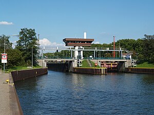
Oberhausen lock
| Oberhausen lock | ||
|---|---|---|
|
Oberhausen lock group, view from the west |
||
| location | ||
|
|
||
| Coordinates | 51 ° 28 ′ 55 " N , 6 ° 49 ′ 15" E | |
| Country: | Germany | |
| Place: | Oberhausen / Lirich | |
| Waters: | Rhine-Herne Canal | |
| Water kilometers : | km 5.68 | |
| Data | ||
| Construction time: | 1979/1984 | |
| lock | ||
| Type: | Lock group (2 locks) | |
| Usable length: | 190/190 m | |
| Usable width: | 11.88 / 11.88 m | |
| Average height of fall : |
4.10 m | |
| Others | ||
The lock Oberhausen heard - from the Rhine ago - for the second time five channels of the Rhine-Herne canal . It is located in the Oberhausen district of Lirich at kilometer 5.68.
Today's lock group bridges a height difference of 4.10 m and has two locks. The southern lock was built between 1977 and 1979 and has a usable length of 190 m and a usable width of 11.99 m. The northern lock was completed on July 28, 1984 after two years of construction and has a usable length of 190 meters and a usable width of 11.88 m.
This lock has a safety device at each chamber for the lower main gate against damage from ships that do not stop in time when entering from the headwater. For this purpose, a thick steel cable is tensioned in front of the gate with a hydraulically operated arm, which can catch ships moving too far. In the picture you can see the rope held high for the exit of the ships. This is necessary here because unloaded ships or those with higher superstructures cannot pass under the tensioned rope. At locks with a higher lifting height, a hydraulically damped locking device fulfills the same purpose, which does not have to be removed for the departure of the ships, as they can extend underneath.
The canal stage also includes a pumping station for water retention in the Rhine-Herne Canal.
The lock can be reached within the inland waterway radio under VHF channel 81.
The Oberhausen lock group is part of the Route of Industrial Culture .
literature
- DIN 4054, hydraulic engineering, terms, September 1977
Web links
- Oberhausen lock. In: Structurae
- The Oberhausen lock at the Duisburg-Meiderich Waterways and Shipping Authority
- Description of this sight on the route of industrial culture


