
Recklinghausen city harbor


The city port of Recklinghausen was put into operation almost simultaneously with the Rhine-Herne Canal in 1914 . Originally, the Recklinghausen urban area did not touch the canal at all, only the acquisition of a 55,000 square meter area from the city of Herne made access possible.
Since the mines had their own ports, the transshipment in Recklinghausen harbor mainly consisted of grain, animal feed, sand, gravel and building materials. During the First World War, food was delivered from the Netherlands. After that, the throughput sank to 14,000 tons in 1931. After the Second World War, the throughput of goods picked up again, in 1949 it was around 140,000 tons, in 1959 even 260,000 tons per year. But then it sank again significantly and in 2000 it was just 24,000 tons.
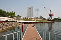
The Emscher Landscape Park 2010 project, with its focus on promoting inland ports, offered the opportunity to develop new usage concepts for the port and the surrounding urban area. For example, high-quality commercial space is to be created on the eastern edge of the harbor basin, while the western part will be prepared for leisure, cultural and residential use. A recreational boat dock and a bridge to the Museum Strom und Leben in the Recklinghausen substation were also planned. The harbor crane, which is under monument protection, is to be made visible as a landmark through a lighting concept.
Some points of the project planning could be realized in the last years. In the commercial sector, Mills United has significantly expanded its capacities; grinding was increased to 400 t / 24h in 2006 and to 520 t / 24h in 2007. The storage capacity was increased to 30,000 t through the construction of new silos for grain and 9,000 t for flour. In addition, a new logistics center with a fully automated high-bay warehouse for small containers in retail is being built. In the leisure-oriented western area, a 3,500 m² beach bar has been operated seasonally for a few years . A jetty for eight pleasure craft has been completed, the quay wall has been restored and the infrastructure in the vicinity has been renovated.
photos
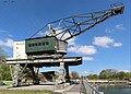
Old crane on the west quay

The abandoned port facilities in 2005
2011 City Harbor, with Mills United building, crane and recreational use

Attempt to revitalize with a beach bar

Before the end of the work - the renovated harbor crane at the new location


Web links
- Description of this sight on the route of industrial culture
- Emscher Landscape Park 2010 - Subproject City Harbor Recklinghausen
Visitor center and anchor points (from west to east): Museum of German Inland Shipping | Inner harbor Duisburg | LVR Industrial Museum Oberhausen | Landscape Park Duisburg-Nord | Gasometer Oberhausen | Aquarius Water Museum | St. Antony Hut | Villa Huegel | Nordsternpark | Zeche Zollverein World Heritage Site and Zollverein Coking Plant | Ewald colliery | Marl Chemical Park | Railway Museum Bochum-Dahlhausen | Henrichshütte | Centennial Hall Bochum | Recklinghausen substation | German Mining Museum | Nightingale colliery | Henrichenburg ship lift | DASA | Hansa coking plant | Zeche Zollern II / IV | Hohenhof | Hagen Open Air Museum | Lindenbrauerei Unna | Maximilian Park Hamm
Themed routes (in ascending order by number): 1. Duisburg: City and Harbor | 2. Industrial cultural landscape Zollverein | 3. Duisburg: industrial culture on the Rhine | 4. Oberhausen: Industry makes the city | 5. Krupp and the city of Essen | 6. Dortmund: triad coal, steel and beer | 7. Industrial culture on the Lippe | 8. Erzbahn-Emscherbruch | 9. Industrial culture at Volme and Ennepe | 10. Brine, steam and coal | 11. Early industrialization | 12. The past and present of the Ruhr | 13. On the way to the blue Emscher | 14. Canals and shipping | 15. Lanes in the area | 16. Westphalian mining route | 17. Rhenish mining route | 18. Chemistry, Glass and Energy | 19. Workers' settlements | 20. Entrepreneur villas | 21. Bread, grain and beer | 22. Myth of the Ruhr Area | 23. Parks and Gardens | 24. Industrial nature | 25. Panoramas and Landmarks | 26. Sacred buildings | 27. Iron & Steel | 28. Water: works, towers and turbines | 29. Bochum - industrial culture in the heart of the district | 30. Gelsenkirchen | 31. Industrial Culture and Bauhaus Route | by bike
Henrichenburg ship lift ![]() |
Waltrop lock park |
Port of Dortmund |
City port of Lünen |
Prussia port |
Marina Rünthe |
Hamm city harbor |
Hamm lock |
Water handover Hamm |
Werries lock |
Way to school footbridge |
Lippe lock Heessen |
Canal bridge Alte Fahrt |
"Schiefe Brücke" and Steverbrücke Olfen |
Canal cross dates |
Datteln-Natrop lock group |
Remote control center for water supply Datteln |
Hermann Grochtmann Museum | Former Lippe lock Datteln |
Port of Victor |
Lock Herne-Ost |
Former lock Herne-West |
Recklinghausen city harbor |
Wanne-Eickel lock |
Port Wanne-West |
Grimberg harbor and ore railway |
City port of Gelsenkirchen |
Gelsenkirchen lock |
Essen city harbor |
Port of Bottrop |
Oberhausen lock |
Gahlener Kohlenweg |
Former Lippe Harbor Wesel |
Municipal Rhine port of Wesel |
Friedrichsfeld lock group |
Fossa Eugeniana |
Orsoy port |
North Harbor Walsum |
Port of Rhine Prussia |
Museum of German Inland Shipping
|
Waltrop lock park |
Port of Dortmund |
City port of Lünen |
Prussia port |
Marina Rünthe |
Hamm city harbor |
Hamm lock |
Water handover Hamm |
Werries lock |
Way to school footbridge |
Lippe lock Heessen |
Canal bridge Alte Fahrt |
"Schiefe Brücke" and Steverbrücke Olfen |
Canal cross dates |
Datteln-Natrop lock group |
Remote control center for water supply Datteln |
Hermann Grochtmann Museum | Former Lippe lock Datteln |
Port of Victor |
Lock Herne-Ost |
Former lock Herne-West |
Recklinghausen city harbor |
Wanne-Eickel lock |
Port Wanne-West |
Grimberg harbor and ore railway |
City port of Gelsenkirchen |
Gelsenkirchen lock |
Essen city harbor |
Port of Bottrop |
Oberhausen lock |
Gahlener Kohlenweg |
Former Lippe Harbor Wesel |
Municipal Rhine port of Wesel |
Friedrichsfeld lock group |
Fossa Eugeniana |
Orsoy port |
North Harbor Walsum |
Port of Rhine Prussia |
Museum of German Inland Shipping ![]() |
Steiger Schifferbörse |
Haniel building complex |
Steiger Swan Gate |
Inner harbor Duisburg
|
Steiger Schifferbörse |
Haniel building complex |
Steiger Swan Gate |
Inner harbor Duisburg ![]() | Private port Hüttenwerke Krupp Mannesmann |
Ruhrschleuse and Ruhrwehr |
Rhine-Ruhr port of Mülheim |
Ruhr lock and Mülheim water station |
Nightingale colliery
| Private port Hüttenwerke Krupp Mannesmann |
Ruhrschleuse and Ruhrwehr |
Rhine-Ruhr port of Mülheim |
Ruhr lock and Mülheim water station |
Nightingale colliery ![]()
Coordinates: 51 ° 33 ′ 37.7 ″ N , 7 ° 12 ′ 37.1 ″ E