
Lock Herne-Ost

The lock Herne-Ost belongs - from the Rhine - to the last of the five canal stages of the Rhine-Herne Canal in Herne . The twin lock is at canal kilometer 37.26. Herne-Ost was put into operation in 1914 as the easternmost of the original seven canal stages of the Rhine-Herne Canal.
The Herne-Ost lock system was renewed between 1986 and 1992. The new lock chambers are each 190 meters long and 12 meters wide. The jamb depth (water depth at the upper gate) is 4 meters. A rotating segment gate forms the end to the upper water . Stem gates close the chambers to the underwater. The difference between the upper and lower water is 12.8 meters. Locking takes approx. 14 minutes, not counting the entry and exit times of the ships.
The two lock chambers are connected in such a way that the draining water from one chamber can be used to fill up the other until there is a tie. Hence the name twin lock . The second half of the water is then drained into the underwater, the other, half-full chamber is filled from the upper water. In this way, the water consumption per lock is halved. Since a canal is a stagnant body of water and not a river, the water loss from the headwater at the locks has to be compensated for by pumping back, which is why this canal stage, like all others, is equipped with a pumping station (see also Hamm water transfer ).

The upper water of the Herne-Ost lock
The lock chamber

Underwater view

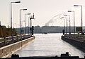
Reemrenreh sculpture, on the left Herne-Ost marina, on the right entrance to the lock
.jpg)
.jpg)
.jpg)
_01_ies.jpg)
The branch canal of the Dortmund-Ems canal from Henrichenburg to Herne, which was added to the Rhine-Herne canal in 1950 , flows into the port of the Friedrich der Große colliery above the current lock .
At the end of the pier between the lock entrance and the Herne-Ost marina stands the Reemrenreh sculpture by Bogomir Ecker , which was erected in the Ruhr area as part of Emscherkunst.2010 during the Capital of Culture year .
literature
- DIN 4054, hydraulic engineering, terms, September 1977
Web links
- The Herne-Ost lock at the Duisburg-Meiderich waterways and shipping office
- Description of this sight on the route of industrial culture
- Lock Herne-Ost. In: Structurae
Individual evidence
- ^ M. Eckoldt (ed.), Rivers and Canals, The History of German Waterways, page 378, DSV-Verlag 1998
Visitor center and anchor points (from west to east): Museum of German Inland Shipping | Inner harbor Duisburg | LVR Industrial Museum Oberhausen | Landscape Park Duisburg-Nord | Gasometer Oberhausen | Aquarius Water Museum | St. Antony Hut | Villa Huegel | Nordsternpark | Zeche Zollverein World Heritage Site and Zollverein Coking Plant | Ewald colliery | Marl Chemical Park | Railway Museum Bochum-Dahlhausen | Henrichshütte | Centennial Hall Bochum | Recklinghausen substation | German Mining Museum | Nightingale colliery | Henrichenburg ship lift | DASA | Hansa coking plant | Zeche Zollern II / IV | Hohenhof | Hagen Open Air Museum | Lindenbrauerei Unna | Maximilian Park Hamm
Themed routes (in ascending order by number): 1. Duisburg: City and Harbor | 2. Industrial cultural landscape Zollverein | 3. Duisburg: industrial culture on the Rhine | 4. Oberhausen: Industry makes the city | 5. Krupp and the city of Essen | 6. Dortmund: triad coal, steel and beer | 7. Industrial culture on the Lippe | 8. Erzbahn-Emscherbruch | 9. Industrial culture at Volme and Ennepe | 10. Brine, steam and coal | 11. Early industrialization | 12. The past and present of the Ruhr | 13. On the way to the blue Emscher | 14. Canals and shipping | 15. Lanes in the area | 16. Westphalian mining route | 17. Rhenish mining route | 18. Chemistry, Glass and Energy | 19. Workers' settlements | 20. Entrepreneur villas | 21. Bread, grain and beer | 22. Myth of the Ruhr Area | 23. Parks and Gardens | 24. Industrial nature | 25. Panoramas and Landmarks | 26. Sacred buildings | 27. Iron & Steel | 28. Water: works, towers and turbines | 29. Bochum - industrial culture in the heart of the district | 30. Gelsenkirchen | 31. Industrial Culture and Bauhaus Route | by bike
Henrichenburg ship lift ![]() |
Waltrop lock park |
Port of Dortmund |
City port of Lünen |
Prussia port |
Marina Rünthe |
Hamm city harbor |
Hamm lock |
Water handover Hamm |
Werries lock |
Way to school footbridge |
Lippe lock Heessen |
Canal bridge Alte Fahrt |
"Schiefe Brücke" and Steverbrücke Olfen |
Canal cross dates |
Datteln-Natrop lock group |
Remote control center for water supply Datteln |
Hermann Grochtmann Museum | Former Lippe lock Datteln |
Port of Victor |
Lock Herne-Ost |
Former lock Herne-West |
Recklinghausen city harbor |
Wanne-Eickel lock |
Port Wanne-West |
Grimberg harbor and ore railway |
City port of Gelsenkirchen |
Gelsenkirchen lock |
Essen city harbor |
Port of Bottrop |
Oberhausen lock |
Gahlener Kohlenweg |
Former Lippe Harbor Wesel |
Municipal Rhine port of Wesel |
Friedrichsfeld lock group |
Fossa Eugeniana |
Orsoy port |
North Harbor Walsum |
Port of Rhine Prussia |
Museum of German Inland Shipping
|
Waltrop lock park |
Port of Dortmund |
City port of Lünen |
Prussia port |
Marina Rünthe |
Hamm city harbor |
Hamm lock |
Water handover Hamm |
Werries lock |
Way to school footbridge |
Lippe lock Heessen |
Canal bridge Alte Fahrt |
"Schiefe Brücke" and Steverbrücke Olfen |
Canal cross dates |
Datteln-Natrop lock group |
Remote control center for water supply Datteln |
Hermann Grochtmann Museum | Former Lippe lock Datteln |
Port of Victor |
Lock Herne-Ost |
Former lock Herne-West |
Recklinghausen city harbor |
Wanne-Eickel lock |
Port Wanne-West |
Grimberg harbor and ore railway |
City port of Gelsenkirchen |
Gelsenkirchen lock |
Essen city harbor |
Port of Bottrop |
Oberhausen lock |
Gahlener Kohlenweg |
Former Lippe Harbor Wesel |
Municipal Rhine port of Wesel |
Friedrichsfeld lock group |
Fossa Eugeniana |
Orsoy port |
North Harbor Walsum |
Port of Rhine Prussia |
Museum of German Inland Shipping ![]() |
Steiger Schifferbörse |
Haniel building complex |
Steiger Swan Gate |
Inner harbor Duisburg
|
Steiger Schifferbörse |
Haniel building complex |
Steiger Swan Gate |
Inner harbor Duisburg ![]() | Private port Hüttenwerke Krupp Mannesmann |
Ruhrschleuse and Ruhrwehr |
Rhine-Ruhr port of Mülheim |
Ruhr lock and Mülheim water station |
Nightingale colliery
| Private port Hüttenwerke Krupp Mannesmann |
Ruhrschleuse and Ruhrwehr |
Rhine-Ruhr port of Mülheim |
Ruhr lock and Mülheim water station |
Nightingale colliery ![]()
Coordinates: 51 ° 33 ′ 50.7 " N , 7 ° 14 ′ 27.8" E