
Walsum North Harbor
| Walsum North Harbor | |||
|---|---|---|---|
| Data | |||
| owner | City of Duisburg | ||
| operator | STEAG | ||
| opening | 1936 | ||
| Port type | Inland port | ||
| Throughput | 2 - 4 million t (2008) | ||
| Geographic information | |||
| place | Walsum | ||
| country | North Rhine-Westphalia | ||
| Country | Germany | ||
 |
|||
| Coordinates | 51 ° 31 '51 " N , 6 ° 42' 46" E | ||
|
|||

The northern port of Walsum is located in Walsum on the Lower Rhine at kilometer 793 on the right and is the northernmost port in the area of the city of Duisburg .
history
The north port was built from 1933 to 1936 as the youngest Duisburg port and works port of the Walsum colliery . Today it is the port of the Duisburg-Walsum power plant . At the end of the Second World War , the facilities were destroyed and were rebuilt by 1950.
Up until the closure of the Walsum mine in 2008, part of the coal and tailings extracted there was shipped via the port and thus across the Rhine; the turnover was two to four million tons per year. The remaining part of the coal was converted into electricity in the neighboring Duisburg-Walsum power plant .
After the mine was closed, the facilities on the southern apron of the port basin (luffing cranes, raw coal bunker, track systems) were dismantled and facilities for the delivery and interim storage of imported coal and the removal of the power plant ash were built in the course of the construction of power plant block 10.
The port was operated by RAG until the mine was closed . It has been operated by Steag since 2008 .
Infrastructure
The harbor basin is 450 meters long and 70 meters wide and at the canal-like connection to the Rhine an extension as a turning point. The quay to the south is rounded to a length of 230 m and is flood-proof. The north side is sloped at 440 m. There are two luffing cranes, various track and belt conveyor systems available to equip the port, but the port railway only opens up the power plant, not the pier. Local roads lead from the port to the federal motorway 59, which runs 2.5 km to the east .
The passenger ship does not drive the North Harbor. For recreational boating, there is a jetty suitable for small vehicles at the turning point in the port entrance.
Others
Königstraße crosses the harbor at the turning basin by means of a lift bridge ; so the port can also be approached during high tide . The bridge was built in 1934-36, blown up in March 1945 by retreating armed forces and rebuilt in 1950. It has been closed to car traffic since October 2012 due to structural defects and can only be passed by pedestrians and cyclists. Walsum also has the southern port of Walsum .
The Orsoy – Walsum car ferry crosses the Rhine directly to the south of the mouth of the port, and the Orsoy port is opposite .
To the north of the northern port, the Rheinaue Walsum extends to the right of the Rhine .
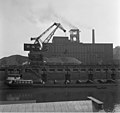
Colliery and coal mine power station (1962)

The Walsum harbor in 1962 with a coal ship, behind it the colliery and the power station

Colliery power station, units 6, 7 and 8 (1962)

Entrance, turning point and jetty for small vehicles, view from the east (2011)


Web links
Individual evidence
- ↑ Entry on the Walsum mine and power station in the " KuLaDig " database of the Rhineland Regional Council , accessed on September 8, 2017.
- ↑ metropoleruhr.de, Walsum power station
- ↑ The renovation of the Walsum lift bridge at the northern port is uncertain, Gregor Herberhold, WAZ from July 20, 2017
- ↑ rottenplaces.de, Uncertain future for Walsumer Hubbrücke im Nordhafen, by André Winternitz, from July 21, 2017
Visitor center and anchor points (from west to east): Museum of German Inland Shipping | Inner harbor Duisburg | LVR Industrial Museum Oberhausen | Landscape Park Duisburg-Nord | Gasometer Oberhausen | Aquarius Water Museum | St. Antony Hut | Villa Huegel | Nordsternpark | Zeche Zollverein World Heritage Site and Zollverein Coking Plant | Ewald colliery | Marl Chemical Park | Railway Museum Bochum-Dahlhausen | Henrichshütte | Centennial Hall Bochum | Recklinghausen substation | German Mining Museum | Nightingale colliery | Henrichenburg ship lift | DASA | Hansa coking plant | Zeche Zollern II / IV | Hohenhof | Hagen Open Air Museum | Lindenbrauerei Unna | Maximilian Park Hamm
Themed routes (in ascending order by number): 1. Duisburg: City and Harbor | 2. Industrial cultural landscape Zollverein | 3. Duisburg: industrial culture on the Rhine | 4. Oberhausen: Industry makes the city | 5. Krupp and the city of Essen | 6. Dortmund: triad coal, steel and beer | 7. Industrial culture on the Lippe | 8. Erzbahn-Emscherbruch | 9. Industrial culture at Volme and Ennepe | 10. Brine, steam and coal | 11. Early industrialization | 12. The past and present of the Ruhr | 13. On the way to the blue Emscher | 14. Canals and shipping | 15. Lanes in the area | 16. Westphalian mining route | 17. Rhenish mining route | 18. Chemistry, Glass and Energy | 19. Workers' settlements | 20. Entrepreneur villas | 21. Bread, grain and beer | 22. Myth of the Ruhr Area | 23. Parks and Gardens | 24. Industrial nature | 25. Panoramas and Landmarks | 26. Sacred buildings | 27. Iron & Steel | 28. Water: works, towers and turbines | 29. Bochum - industrial culture in the heart of the district | 30. Gelsenkirchen | 31. Industrial Culture and Bauhaus Route | by bike
.jpg)
Landscape Park Duisburg-Nord ![]() |
Ratingsee settlement |
Momentive / Rütgers |
Green path |
Grillo works |
Friedrich Thyssen mine shaft 6 |
Poets Quarter |
Bergmannsplatz settlement |
Schmidthorst pumping station |
Wehofen settlement |
Little Emscher |
Emscher estuary sewage treatment plant |
Walsum mine |
North Harbor Walsum |
Walsum power plant |
Schwelgern pumping station |
Alsumer Berg
|
Ratingsee settlement |
Momentive / Rütgers |
Green path |
Grillo works |
Friedrich Thyssen mine shaft 6 |
Poets Quarter |
Bergmannsplatz settlement |
Schmidthorst pumping station |
Wehofen settlement |
Little Emscher |
Emscher estuary sewage treatment plant |
Walsum mine |
North Harbor Walsum |
Walsum power plant |
Schwelgern pumping station |
Alsumer Berg ![]() |
Alte Emscher pumping station |
Haus-Knipp railway bridge |
Koenig Brewery |
Old Thyssen headquarters |
Railway and ports | Shipyards: Meidericher Schiffswerft , Neue Ruhrorter Schiffswerft and Triton-Werft | Lifting tower of the Ruhrort-Homberger Trajektanstalt |
Plan mill Homberg |
Johannenhof settlement |
Rheinpreußen colliery shaft 1/2 |
Rheinpreußen settlement
|
Alte Emscher pumping station |
Haus-Knipp railway bridge |
Koenig Brewery |
Old Thyssen headquarters |
Railway and ports | Shipyards: Meidericher Schiffswerft , Neue Ruhrorter Schiffswerft and Triton-Werft | Lifting tower of the Ruhrort-Homberger Trajektanstalt |
Plan mill Homberg |
Johannenhof settlement |
Rheinpreußen colliery shaft 1/2 |
Rheinpreußen settlement ![]() |
Sachtleben Chemie |
Rheinhauser Bergbausammlung e. V. |
Rheinhausen-Bergheim water tower |
Bridge of Solidarity |
Duisburg-Hochfelder Railway Bridge |
Margarethensiedlung |
Krupp Hüttenwerke Gate 1 |
Official housing estate Bliersheim and Casino Krupp |
Rheinhausen-Friemersheim water tower |
Inner harbor Duisburg
|
Sachtleben Chemie |
Rheinhauser Bergbausammlung e. V. |
Rheinhausen-Bergheim water tower |
Bridge of Solidarity |
Duisburg-Hochfelder Railway Bridge |
Margarethensiedlung |
Krupp Hüttenwerke Gate 1 |
Official housing estate Bliersheim and Casino Krupp |
Rheinhausen-Friemersheim water tower |
Inner harbor Duisburg ![]() |
Museum of German Inland Shipping
|
Museum of German Inland Shipping ![]() |
Kasslerfeld sewage treatment plant |
Rhine orange |
Barrier gate Marientor |
Hochfeld water tower |
DEMAG (today Siemens) |
Hüttenwerke Krupp Mannesmann (HKM) |
Port of the Hüttenwerke Krupp Mannesmann |
Hüttenheim settlement |
Krefeld-Uerdinger Bridge |
Bockum waterworks |
Railway workers' settlement Wedau |
Shunting yard and repair shop Wedau |
Railway workers' settlement Bissingheim |
Dickelsbach settlement |
House Hartenfels |
Bridge landscape Ruhraue |
Duisburg Central Station
|
Kasslerfeld sewage treatment plant |
Rhine orange |
Barrier gate Marientor |
Hochfeld water tower |
DEMAG (today Siemens) |
Hüttenwerke Krupp Mannesmann (HKM) |
Port of the Hüttenwerke Krupp Mannesmann |
Hüttenheim settlement |
Krefeld-Uerdinger Bridge |
Bockum waterworks |
Railway workers' settlement Wedau |
Shunting yard and repair shop Wedau |
Railway workers' settlement Bissingheim |
Dickelsbach settlement |
House Hartenfels |
Bridge landscape Ruhraue |
Duisburg Central Station
Henrichenburg ship lift ![]() |
Waltrop lock park |
Port of Dortmund |
City port of Lünen |
Prussia port |
Marina Rünthe |
Hamm city harbor |
Hamm lock |
Water handover Hamm |
Werries lock |
Way to school footbridge |
Lippe lock Heessen |
Canal bridge Alte Fahrt |
"Schiefe Brücke" and Steverbrücke Olfen |
Canal cross dates |
Datteln-Natrop lock group |
Remote control center for water supply Datteln |
Hermann Grochtmann Museum | Former Lippe lock Datteln |
Port of Victor |
Lock Herne-Ost |
Former lock Herne-West |
Recklinghausen city harbor |
Wanne-Eickel lock |
Port Wanne-West |
Grimberg harbor and ore railway |
City port of Gelsenkirchen |
Gelsenkirchen lock |
Essen city harbor |
Port of Bottrop |
Oberhausen lock |
Gahlener Kohlenweg |
Former Lippe Harbor Wesel |
Municipal Rhine port of Wesel |
Friedrichsfeld lock group |
Fossa Eugeniana |
Orsoy port |
North Harbor Walsum |
Port of Rhine Prussia |
Museum of German Inland Shipping
|
Waltrop lock park |
Port of Dortmund |
City port of Lünen |
Prussia port |
Marina Rünthe |
Hamm city harbor |
Hamm lock |
Water handover Hamm |
Werries lock |
Way to school footbridge |
Lippe lock Heessen |
Canal bridge Alte Fahrt |
"Schiefe Brücke" and Steverbrücke Olfen |
Canal cross dates |
Datteln-Natrop lock group |
Remote control center for water supply Datteln |
Hermann Grochtmann Museum | Former Lippe lock Datteln |
Port of Victor |
Lock Herne-Ost |
Former lock Herne-West |
Recklinghausen city harbor |
Wanne-Eickel lock |
Port Wanne-West |
Grimberg harbor and ore railway |
City port of Gelsenkirchen |
Gelsenkirchen lock |
Essen city harbor |
Port of Bottrop |
Oberhausen lock |
Gahlener Kohlenweg |
Former Lippe Harbor Wesel |
Municipal Rhine port of Wesel |
Friedrichsfeld lock group |
Fossa Eugeniana |
Orsoy port |
North Harbor Walsum |
Port of Rhine Prussia |
Museum of German Inland Shipping ![]() |
Steiger Schifferbörse |
Haniel building complex |
Steiger Swan Gate |
Inner harbor Duisburg
|
Steiger Schifferbörse |
Haniel building complex |
Steiger Swan Gate |
Inner harbor Duisburg ![]() | Private port Hüttenwerke Krupp Mannesmann |
Ruhrschleuse and Ruhrwehr |
Rhine-Ruhr port of Mülheim |
Ruhr lock and Mülheim water station |
Nightingale colliery
| Private port Hüttenwerke Krupp Mannesmann |
Ruhrschleuse and Ruhrwehr |
Rhine-Ruhr port of Mülheim |
Ruhr lock and Mülheim water station |
Nightingale colliery ![]()