Emscherland
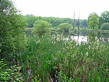
The Emscherland is a natural spatial main unit in the south of the main unit group Westphalian Bight in North Rhine-Westphalia . It occupies large parts of the catchment area of the eponymous Emscher , but not its marginal hills in the south, east and northeast and the estuary.
Most of the Emscherland belongs to the historical Vest Recklinghausen , which, however, did not cross the Emscher to the south and reached to the north as far as the Lippe , of which parts of the catchment area on the left also belong to the Emscherland.
The potential natural plant community of the Emscherland would be predominantly an English oak-hornbeam forest landscape (Stellario-Carpinetum) . Today the natural area is largely characterized by settlement and cultivated land in the Ruhr area , in the north and in the far east it is also used for agriculture. In four regional green corridors of the Ruhr Regional Association with parts of the Emscherland, there is often vegetation in forests and nature reserves that corresponds to the potential natural plant communities.
Location and limits
The Emscherland encompasses the valley of the eponymous river Emscher from Dortmund-Dorstfeld to the transition to the Rhenish sand plates west of the Gladbeck line and the center of Bottrop, as well as edge plates north and south of the Emscher valley. In the south, the Emscherland borders the landscape of the Westenhellweg . To the north, flat, undulating ridges flank the Emscher lowlands and to the north border on the natural spatial units of Westmünsterland and Kernmünsterland.
Many cities in the northern and central Ruhr area have a share in the natural areas Emscherland and Westenhellweg, from west to east these are Oberhausen (small parts in the extreme east), the north of Essen in the Emscher Valley , the majority of the urban area of Herne , the northern half of Castrop- Rauxels around Rauxel and northern districts of Dortmund around Mengede .
Bottrop , Gladbeck , Gelsenkirchen , Herten , Recklinghausen , as well as Oer-Erkenschwick , Datteln and Waltrop are located in the core area , unless they belong to the Westmünsterland in the peripheral area.
In the north, at the interface to Westmünsterland , about the (southern) half of the Marl urban area is in the natural area, in the extreme east Brambauer , a western district of Luenen .
Natural structure
The Emscherland is structured as follows:
-
(to 54 Westphalian Bay )
- 543 Emscherland
- 543.0 Vestical ridge ( Recklinghauser Land ridge )
- 543.00
- 543.01 Buerscher ridge
- 543.02 Marler flat waves
- 543.0 Vestical ridge ( Recklinghauser Land ridge )
- 543.1 Oer-Waltroper flat waves
- 543.10 Waltroper flat waves
- 543.11 Emscher-Lippe-Platten
- 543.12 Bockumer hill waves
- 543.13
- 543.14 Erkenschwick Valley
- 543 Emscherland
- 543.2 Emschertal
- 543.20 Emscher valley
- 543.21 Northern Emscher rim plates
- 543.22 Southern Emscher edge plates
- 543.23 Boyeplates
description
It is named after the river Emscher in the southern Emscherland, whose valley was washed out by meltwater during the last ice age . Originally, the landscape along the river valley was characterized by extensive swamp forests , the Emscherbruch , and wide floodplains along the strongly meandering river. Up until the beginning of the 19th century, the Bruch was used as a wild stud for horses, the Emscherbrücher .
Today the landscape is shaped by the Emscher zone of the Ruhr area and shaped by urban settlements and industrial areas. The Emscher itself has been almost completely straightened and diked. Part of the old swamp forests survived industrialization as part of the “regional green corridors” from the 1920s or as a so-called “colliery swamp”. In the second case, the areas were used for the aboveground water flow for the dewatering of the mines. With the disappearance of mining, these areas were integrated into the Emscher Landscape Park . The name of the meadow landscape is preserved in the Emscherbruch landscape park , which includes part of the original quarry forest.
The north of the Emscherland is often used for agriculture, and there are occasional small forests there. Forest areas are mainly characterized by beech stands. The agglomeration of the urban area of Marl is an exception.
The in eastern Recklinghausen's 113 m ( Fritz mountain north of most than today Quellberg designated hamlet Hillen ) reach and Emscher and the Rhine-Herne Canal just south of the back around 70 m superior Vestische ridge between the valleys of the rivers Emscher and Lippe , whose In the middle and eastern part, the waters drain southwards towards the Emscher, while in the west the valleys face north. The bottom consists of loamy or sandy covers on marl sands or marl sand.
Potential vegetation
In addition to the common oak-hornbeam forest (Stellario-Carpinetum) , which is considered to be predominant, other plant communities are to be expected. On the loess soils of the Vestic Ridge, the potential vegetation would be large-scale beech forest (Maianthemo-Fagetum = Milio-Fagetum) . Above the calcareous Emscher marl there would also be woodruff beech forest (Galio-Fagetum) , in the area of the Emscher floodplains also ash floodplain forest (Querco-Ulmetum minoris = Fraxino-Ulmetum) , birch break forest (Betulum pubescentis) and, on particularly wet locations, alder break forest (Carici-Alnetum) to be expected.
Views
Southern Emscherland
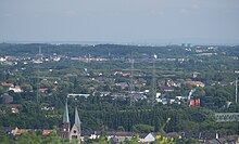
View over the southern Emscherland in the border area of Recklinghausen and Herten from the Hoppenbruch heap to the north. In the middle of the picture, the border to Westenhellweg runs almost horizontally in this perspective. The Castroper Heights with the Beimberg can be seen in the background, on it the Kaiser Wilhelm Tower in the Volkspark Sodingen, and in the background the two water towers of Gelsenwasser near the A 43.
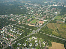
Aerial view of the Emscherland near Castrop-Rauxel to the north-west. The Forum Europaplatz can be seen in the center of the picture, to the right of it the Grutholz / Nierholz begins. At the top left of the picture, the Castroper wood is partially taken, behind it Bladenhorst Castle and the Dickenheide. The Emscher runs right at the top left of the picture .
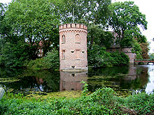
The natural conditions in the Emscherland were used for the construction of moated castles, here the southern moats of Herten Castle and the moats of Bladenhorst Castle in Castrop-Rauxel.
Industrialization has changed the Emscherland. View from the Hoheward dump to the west. In front the decommissioned Ewald mine , in the center of the picture the Hertener Mark in the Emscherbruch landscape park , in the back the Scholven power plant and the Oberscholven dump .
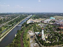
The Emscher is channeled, here, on the left in the picture, near Oberhausen. The Rhine-Herne Canal was built parallel to it as a shipping route, here to the right of the river. In the foreground, the view still stretches over the "Middle Lower Rhine Plain", the Emscherland begins shortly before the first white bridge that spans the canal and river.
literature
- Krone, Nikola: The landscape park Bladenhorst-Castroper Holz: a model project of the municipal association Ruhrgebiet as part of the international building exhibition Emscher Park , publisher: Kommunalverband Ruhrgebiet, Essen 1994.
Web links
-
Natural area maps from the single sheets 1: 200,000 of the Federal Institute for Regional Studies - all units beginning with "543" are relevant here
- Sheet 95/96 - Kleve / Wesel (east)
- Sheet 97 - Münster (west)
- Sheet 108/109 Düsseldorf / Erkelenz (east)
- The Castroper Holz , Grutholz / Nierholz and the Beerenbruch as neighboring parts of the low-lying forest in the Emscherland, RVR
- View over the Emscherland near Deusen , Thomas Höckmann
- Description of all locations on this themed route as part of the Route of Industrial Culture
Individual evidence
- ↑ Map services of the Federal Agency for Nature Conservation ( information ) - Map service "Protected areas" shows the boundaries of the main unit group ("Natural areas") and the main units, the somewhat coarser map service "Landscapes" divides the natural areas a little more finely.
- ^ Emil Meynen and Josef Schmithüsen : Handbook of the natural spatial structure of Germany - Federal Institute for Regional Studies. 6th delivery, Remagen 1959 (a total of 9 deliveries in 8 books 1953–1962, updated map 1: 1,000,000 with main units 1960)
- ^ Geographical survey of the country: The natural space units on sheet 95/96 - Kleve / Wesel (Wilhelm von Kürten 1977; east), sheet 97 - Münster (Sofie Meisel 1960; west) and sheet 108/109 - Düsseldorf / Erkelenz (Karlheinz Pasffen, Adolf Schüttler and Heinrich Müller-Miny 1963, East) - Federal Institute for Regional Studies, Bad Godesberg
- ↑ On Sheet 97 - Munster are the Waltroper flat waves of 1960 on the territory, is not further subdivided 543.1 and as Waltroper flat shaft country called. The sub-unit is only mentioned on sheet 95/96 - Kleve / Wesel from 1977. According to the latter, the Emscher-Lippe-Platten (543.11) separate the Waltrop flat waves (543.10) in the south-east from the Bockumer hill waves (543.12) in the north-west, which are located outside the map section .

