
Emscher
| Emscher | ||
 The Emscher spring at the Emscherquellhof in Holzwickede |
||
| Data | ||
| Water code | EN : 2772 | |
| location | Germany | |
| River system | Rhine | |
| Drain over | Rhine → North Sea | |
| source | at Holzwickede on Haarstrang 51 ° 29 '25 " N , 7 ° 36' 46" E |
|
| Source height | approx. 147 m above sea level NN | |
| muzzle | near Dinslaken - Eppinghoven in the Rhine Coordinates: 51 ° 33 ′ 48 " N , 6 ° 41 ′ 22" E 51 ° 33 ′ 48 " N , 6 ° 41 ′ 22" E |
|
| Mouth height | 18 m above sea level NN | |
| Height difference | approx. 129 m | |
| Bottom slope | approx. 1.6 ‰ | |
| length | 83.1 km | |
| Catchment area | 775.466 km² | |
| Outflow at the Oberhausen Königstrasse gauge |
MNQ 1979/2001 MQ 1979/2001 MHQ 1979/2001 |
9.38 m³ / s 16.3 m³ / s 132 m³ / s |
| Big cities | Dortmund , Recklinghausen , Herne , Gelsenkirchen , Essen , Bottrop , Oberhausen , Duisburg . | |
The Emscher ( Low German Iämscher ) is an 83.1 kilometer long right tributary of the Rhine in the Ruhr area . With its catchment area, it was River Landscape of the Year in 2010 and 2011.
geography
course


The Emscher rises southeast of Dortmund near Holzwickede ( Unna district ) on Haarstrang at about 147 m above sea level. NN in a spring pond. Strictly speaking, there are several smaller rivulets that flow into said pond and form the origin here.
In its upper reaches, the Emscher flows through the southeast of Dortmund (Dorstfeld) - only separated from the Ruhr valley by the Haarstrang ridge or the Ardey Mountains - and then turns to the northwest. In the northern Castrop-Rauxel it crosses under the Rhine-Herne Canal in a culvert structure with three concrete tubes. It then flows almost continuously parallel to this canal in a westerly direction as far as Oberhausen . In Oberhausen, the river bends to the northwest and then flows to its current confluence with the Rhine near Dinslaken-Eppinghoven .
There their flow rate has increased to an average of 16 m³ / s. The geography of the Emscher valley was used when building the canal . The Emscher flows through the urban area of Dortmund, Castrop-Rauxel, Recklinghausen , Herten , Herne , Gelsenkirchen , Essen , Bottrop , Oberhausen, Duisburg and Dinslaken.
Its 83.1 km long run ends about 129 meters below its source, so it has an average bed gradient of 1.6 ‰.
The catchment area of the river is 775.466 km² with a system of branched tributaries.
Tributaries
All tributaries of the Emscher from 8 km² catchment area are listed below:
(For a better overview or for sorting downstream, hyphens are inserted in the DGKZ numbers after 2772 - Emscher .)
| Surname | location | Length [km] |
Catchment area [km²] |
Emscher-km (before mouth) |
Places on the river (*: source) |
Muzzle (at) |
DGKZ |
|---|---|---|---|---|---|---|---|
| Hörder Bach | Left | 6.2 | 12.2 | 72.0 | * DO - Berghofen | DO- Hörde | 2772-12 |
| Schondelle | Left | 6.2 | 11.8 | 69.6 | * DO- Wellinghofen , DO - Lücklemberg | DO- Brünninghausen | 2772-14 |
| Rüpingsbach | Left | 8.0 | 36.7 | 66.8 | * Witten - Annen , DO - Hombruch | DO- Schönau | 2772-16 |
| Roßbach ( Schmechtingsbach ) | Left | 7.6 | 30.9 | 62.1 | DO- Kley , DO- Marten | DO wafers | 2772-2 |
| Nettebach | Left | 7.5 | 16.8 | 58.9 | * DO- Kirchlinde | DO- Nice | 2772-32 |
| Herdicksbach | right | 7.5 | 9.9 | 50.5 | * South Waltrops | East Castrop-Rauxel - Henrichenburgs | 2772-336 |
| Landwehrbach | Left | 6.4 | 44.2 | 42.4 | * Castrop | Herne - Horsthausen | 2772-34 |
| Hellbach | right | 6.7 | 20.4 | 40.5 | * Recklinghausen | RE - south | 2772-36 |
| Ostbach | Left | 6.9 | 12.4 | 40.1 | * BO - Gerthe | HER - Baukau | 2772-372 |
| Holzbach | right | 7.4 | 30.3 | 34.8 | * Herten - Westerholt | GE - Resser Mark | 2772-392 |
| Hüller Bach | Left | 17.2 | 80.9 | 34.0 | * BO- Weitmar , BO- Hamme | GE Bismarck | 2772-4 |
| Börnchenbach | right | 5.3 | 9.0 | 33.4 | * East GE Buers | GE alder | 2772-52 |
| Sellmannsbach | Left | 2.8 | 11.1 | 31.0 | GE Bismarck | GE- Schalke -Nord | 2772-54 |
| Lanferbach | right | 4.1 | 9.9 | 28.9 | * Southwest of GE-Buers | GE- Horst | 2772-56 |
| Schwarzbach | Left | 13.1 | 49.0 | 26.7 | * E - Frillendorf , E- Schonnebeck | GE- Hessler | 2772-58 |
| Boye | right | 13.8 | 74.4 | 24.3 | Southwest BOT - Kirchhellens , border BOT / Gladbeck | BOT- Welheim / E- Karnap border | 2772-6 |
| Berne | Left | 8.6 | 62.1 | 20.7 | * Essen , E- Altenessen , Bottrop-Ebel | Bottrop-Ebel | 2772-8 |
| Läppkes Mühlenbach | Left | 3.0 | 8.8 | 17.3 | Oberhausen -East | OB - Borbeck | 2772-916 |
| Handbach | right | 5.4 | 23.5 | 10.7 | * OB- Walsumermark | OB- Black Heath | 2772-96 |
The old arms of the Kleine Emscher (277134; 10.3 km; 35.0 km²) and Alte Emscher (277132, 7.8 km, 29.2 km²), which were created by the relocation of the Emscher estuary to the north, flow directly into the Rhine and are therefore no longer part of the Emscher river system.
Emschertal natural area
The valley of the Emscher between Dortmund city center and the separation from the hitherto parallel Rhine-Herne Canal at Oberhausen , the natural spatial subunit Emschertal the main unit Emscherland . The latter is broadly consistent with the catchment area of the Emscher without source and mouth run but saves by South the headwaters of some tributaries on the Castroper Platten , which belong to the Westenhellweg . In the north, the Emscherland also includes areas that overhang the Lippe .
Natural structure
The Emschertal is structured as follows:
-
(to 543 Emscherland )
- 543.2 Emschertal
- 543.20 Emscher valley
- 543.21 Northern Emscher rim plates
- 543.22 Southern Emscher edge plates
- 543.23 Boyeplates
- 543.2 Emschertal
description

The Emschertal existed even before the Saale glaciated. At the end of the 19th century, the Emscher meandered through its 5 km wide valley between Herten and Wanne-Eickel . Flooding of larger areas was not uncommon. Oak and hornbeam forests dominated the floodplains and quarry forests in more swampy areas .
Since the Emschergenossenschaft was founded in 1899, the Emscher and its tributaries have been canalized and straightened after swamping occurred in subsidence areas. The river bed was also deepened several times. In addition, the confluence with the Rhine was shifted north twice. This led to a lowering of the groundwater level in some areas. Since, however, subsidence has occurred again and again to this day as a result of the coal mining, the natural receiving water is still disturbed, so that larger areas have to be regularly kept dry using pumping stations. In the area of the actual Emschertal, the elevation of the eponymous river drops from 70 m in Dortmund to around 35 m south of Bottrop .
course

After the Emscher in the Witten-Hörder Mulde has flowed around the Dortmund Ridge, first to the south and then to the west, it enters the actual Emschertal immediately west of the Dortmund city center. The Dortmund harbor on the Dortmund-Ems Canal is also located east of the Emscher in this natural area, which the canal will soon leave.
A significant widening of the valley occurs in Castrop-Rauxel - Henrichenburg , where the Emscher crosses under the Rhine-Herne Canal at about 60 m above sea level and changes its course from northwest to southwest.
The first noticeable widening of the valley can be found immediately south of Recklinghausen , where the side valley of the Hellbach extends right up to the city center. Similarly long, albeit less wide, a little further west and also to the right of the Emscher, the valley of the Holzbach cuts to Herten - Westerholt . The valley of what is now known as the Resser Bach ran parallel to the two last-mentioned brooks and between them, on the city limits between Recklinghausen and Herten. However, the Resser Bach is now diverted to the Holzbach, which it meets east of Gelsenkirchen-Resse .
To the west of Grimberg Castle , the Emscher divided into the main river, which flowed north around Horst Castle , and a southern tributary, called the Kleine Emscher, until the 19th century . The straightened Emscher follows this tributary at Gelsenkirchen-Horst, while the lower part of the former main river has been preserved as the Alte Emscher near Horst .
Further down the Emscher, also on the right, northern side, there is the - somewhat less noticeable - valley cut of the Lanferbach and, opposite to the south, the cut of the Schwarzbach - both flowing into Gelsenkirchen .
Edge plates
The northern and southern edge plates of the Emscher valley are each only 5 m - 20 m higher than the Emscher valley itself.
While the southern edge plates are not interrupted by side valleys, not even by that of the Schwarzbach, the northern ones are segmented into individual flats by Hellbach, Resser Bach, Holzbach and Lanferbach. The westernmost of those five plates near Gelsenkirchen-Beckhausen flows westward into the Boyeplatten of the Boye , the second largest tributary of the Emscher.
The Boyeplates, on which a large part of Bottrop lies, take up more space than all the other edge panels put together. In addition, near Kirchhellen in the north they create a corridor to the Dorsten valley widening of the Lippe near Dorsten via a low water divide only 51 m high .
Adjacent natural areas
The following natural areas border downstream on the Emschertal, which continues the Witten-Hörder Mulde to the north (according to the indent the associated main unit):
- right the Emscher
- Dortmund Ridge (southeast) - Hellwegbörden
- Dortmund Hellwegtal (south east) - Hellwegbörden
- Derner Höhe (east) - Hellwegbörden
-
Oer-Waltroper flat waves (north east to north east) - Emscherland
- Waltroper flat waves (north east)
- Emscher-Lippe-Platten (northeast)
-
Vestic ridge (north) - Emscherland
- Recklinghauser loess ridge (eastern north)
- Buerscher ridge (more western north)
- Dorsten valley widening - Westmünsterland
-
Königshardter sand plates (north west) - Lower Rhine sand plates
- Königshardter main terrace slab (north west)
- Hiesfeld - Sterkrader Mittelterrassen (narrow corridor in the far west)
- left the Emscher
-
Castroper Platten (east south) - Westenhellweg
- Marten flat wave land
- Unterer Westenhellweg (south) - Westenhellweg
-
Castroper Platten (east south) - Westenhellweg
In the south west, the Emscher (on both sides) enters the Ruhr-Emscher-Platte , the lower terrace level on the right bank of the Rhine , the main unit of the Middle Lower Rhine Plain , and leaves the Westphalian Bight .
Renaturation


Around the middle of the twentieth century the Emscher was considered the dirtiest river in Germany and the "sewer of the Ruhr area". With the predominant end of mining in the Ruhr area or its north migration, subsidence in the Emscher region is no longer an obstacle, so that the construction of underground canals and the renaturation of the Emscher began.
The first steps towards ecological reconstruction of the Emscher system were taken with the IBA Emscherpark , including the Emscher-Weg and Emscher Park Radweg cycle paths and the Emscher Landscape Park . In the 1990s, a short section of the Emscher was renatured as part of the Federal Garden Show in Dortmund.
The central structure in the course of the renaturation of the Emscher is the Emscher Canal. On August 13, 2008, the planning approval decision of the Münster district government for the sewer along the Emscher was sent to the chairman of the board of the Emschergenossenschaft, Dr. Jochen Stemplewski presented. The canal running from Dortmund to Dinslaken is 51 km long and has a maximum diameter of 2.80 m. It will divert the wastewater to the existing Bottrop and Emschermünde sewage treatment plants, replace the previous open wastewater discharge and be completed by 2017. Subsequently, the Emscher can be redesigned in other areas in a natural way.
The Emscherquellhof , located at the source of the Emscher, was completely renovated in 2005 by the Emschergenossenschaft and is used for exhibitions and as a conference and educational center.
On December 18, 2009, the renatured, aboveground bed of the Emscher was flooded in Hörde . After the Emscher had flowed under the Hermannshütte at this point for over 100 years , clean water now flows through a near-natural river bed parallel to the Phoenixsee . A vineyard slope was also laid out again at Lake Phoenix.
As part of the Capital of Culture year Ruhr.2010 was the Emscherkunst.2010 on the recorded Emscher Island alerted and the current conversion of the Emscher system.
The redesign of the Emschertal was recognized by the UN in 2014 as an "example of a large-scale participatory eco-project". The Emschergenossenschaft has been planning and implementing the generation project for the conversion of the Emscher system since 1992 , in which 5.38 billion euros will be invested over a period of around 30 years.
hazards

The canalised river bed of the Emscher harbors a high risk potential for people who get into the river bed due to the sloping, very smooth and slippery concrete walls. Despite the fencing and signage, the canalized Emscher has cost many lives. In 1983 the writer Michael Holzach drowned in the Emscher while trying to save his dog.
history

In the Middle Ages, the upper and middle reaches of the river were in large parts the natural border of territories. To the north of the river lay the area of Vest Recklinghausen in large areas , to the south that of Grafschaft Mark and Essen monastery . The Emscher also formed the southern and western borders of the county of Dortmund . Numerous moated castles were therefore built along the Emscher, waiting on the borders of the county of Dortmund . In a document from Archbishop Pilgrim of Cologne from 1027 for the Essen monastery, the Emscher is named as Embiscara , until which, according to the abbess Sophia von Essen, daughter of Emperor Otto II. The Emscher existed as a border, but its name changed to Emschar by the late Middle Ages .
Originally, the Emscher was a river that meandered strongly in the middle course , the total length was 109 kilometers. In the Middle Ages, viticulture was practiced on the slopes of the upper Emscher Valley near Hörde . Today the street names Winzerweg and Weingartenstraße in Hörde remind of this usage. In the wide valley on the middle Emscher and on its lower reaches in the Rhine plain, vast swamp forests stretched . The quarry was used extensively for agriculture as a wilderness for breeding horses in the Emscherbrücher . In the valley there were, typical of the region, scattered village settlements and individual farms, mostly in a geographically safe location from floods. At a certain distance from one another, church villages such as Herne, Buer, Gelsenkirchen, Katernberg and Borbeck were built on the flood-free terrace edges .
Numerous documents prove that the Emscher was an important fishing ground: in 1484 the brothers Walrave, Johan and Hinrick van Ekell shared the fishing in the Emesscher near Crange, in 1563 the nobleman Goddert von Strünkede zu Strünkede litigated Philipp and Arnd von Viermund zu Bladenhorst for the fishing rights on the Emscher before the judge in Castrop, the trial is brought up to the Reich Chamber of Commerce, and in April 1599 the mayor and council of the city of Recklinghausen pledge three aristocratic fishing rights on the Emscher for a loan.
According to the customs of the time, the river was used in witch trials in the early modern period . From 1589 there is a protocol of the Essen monastery about the water test carried out on 18 suspects of magic at the Emscher at their own request , before they proceeded to the embarrassing questioning .


A first project of the 18th century to make the river navigable was rejected by the Prussian King Friedrich II on 23 August 1774 after several years of negotiations . An initiative under the leadership of William Thomas Mulvany from 1873 to expand the river as a shipping route did not have any direct success. The idea of a side canal for shipping was finally realized: at the beginning of the 20th century, the Rhine-Herne Canal was built along the Emscher.
With the onset of early industrialization, process water was taken from the river system for processes. In 1793 the Sterkrade monastery complained that the water had been spoiled because the lawn iron stone was washed at the St. Antony hut . From the middle of the 19th century, the advancing industrialization in the Ruhr area also began a strong population growth. The increased demand for drinking water was covered by the Ruhr and Lippe areas . The sewage and pit water from the mines was mainly discharged into the Emscher from the second half of the 19th century.
The Emscher was heavily polluted by the discharges. The low gradient, the pronounced meandering course of the river and subsidence of the ground caused by mining caused numerous floods at the end of the 19th century, which led to an increasing risk of epidemics due to the faeces carried along . Since the participating municipalities and large companies were unable to solve the problem on their own initiative, the Emschergenossenschaft was finally founded in 1899 as a compulsory union of the affected municipalities and the large companies involved. Their tasks are in wastewater treatment , securing the runoff, flood protection and water maintenance .
Under the aegis of the Emscher Cooperative, the Emscher was lowered by about three meters, and most of it was fortified and straightened. The course of the river was regulated several times. The estuary was relocated twice in the 20th century: in 1910 from Duisburg- Alsum to Duisburg- Walsum and in 1949 to Dinslaken. Accordingly, the Emscher divides on its lower course into Alte Emscher , Kleine Emscher and Neue Emscher. The Alte Emscher flows from Oberhausen through Duisburg-Hamborn , Duisburg-Beeck and Alsum, the Kleine Emscher from Oberhausen through Hamborn and Walsum and the New Emscher from Oberhausen through Dinslaken into the Rhine.
The subsidence caused by mining was compensated for by ever higher dikes , so that today the Emscher is even a few meters above the level of the surrounding area in some places. However, this also means that tributaries to the Emscher, which drain the surrounding land, have to be pumped up into the Emscher. Without the dike and the pumping out of the water, large parts of the Emscher region would stand under water as polders .
Until recently, however, there were no alternatives to open sewage disposal, as underground canals would have regularly sunk due to mountain damage .
Four central wastewater treatment plants were built by the end of the 1990s:
- Sewage treatment plant Duisburg Alte Emscher
- Emscher estuary sewage treatment plant (city limits Dinslaken, Duisburg and Oberhausen)
- Bottrop sewage treatment plant
- Dortmund-Deusen sewage treatment plant

Emscher with high voltage line

Night lighting of digestion towers in Bottrop sewage treatment plant

.jpg)


The course of the Emscher serves as a route for various power lines. In the picture you can see high-voltage lines that connect hard coal-fired power plants (in the background the Steag power plant in Herne) and consumers. The olive-green pipes of the Ruhr district heating rail run along the left bank, into which the power plants feed water from 110 to 180 ° C and thus supply the transfer points to the municipal district heating providers in the Ruhr area.
A passenger ferry operated in Duisburg until 1939 . In 1960 a bridge was built at the same place.
After heavy rainfall of up to 200 l / m² locally, the Emscher and Roßbach floods occurred in the Dortmund area on July 26, 2008, particularly affecting the districts of Dorstfeld and Marten . The Emscher reached new high water levels at many measuring points. For example, a water level of over 520 centimeters was measured at the gauge in Mengede, with a usual level of around 100 centimeters.
Buildings
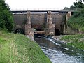
The old Emscher pass under the Rhine-Herne Canal (demolished today)
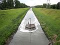
Ventilation of the Emscher in Gelsenkirchen

Waiting for the river Emscherkunst. 2010
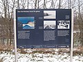
Information sign for the Route of Industrial Culture
.jpg)


The river as namesake
The following institutions, organizations and facilities bear the name Emscher in their name:
- Emschergenossenschaft
- EMSCHERplayer
- Emschertal Museum Herne
- Deanery Emschertal
- Emscher Fountain
- Emscherbruch
- Emscherkunst.2010 on the Emscher Island
- Emscherkurve, home area of the Rot-Weiß Oberhausen fans in the Niederrhein stadium .
- Emscherkurve 77 , a German punk band named after it
- Emscherschnellweg, Autobahn A 42
- Radio Emscher Lippe
literature
- Ecological renewal of an industrial landscape . In: DVWK German Association for Water Management and Cultural Building e. V. (Ed.): Series of publications by the German Association for Water Management and Cultivation . Issue 108. Wirtschafts- und Verlagsgesellschaft Gas und Wasser, Bonn 1994, ISBN 3-922671-44-6 .
- Otto Dickau, Christoph Eger (eds.): Emscher. Contributions to the archeology of a river landscape in the Ruhr area . Aschendorff, Münster 2014, ISBN 978-3-402-13071-1 .
- Klaus Gorzny, Claas Marlori: Castles, palaces and aristocratic residences in the Emscher Landscape Park . Piccolo, Marl 2001, ISBN 3-9801776-5-3 .
- Everything flows - the water of the Emscher . In: Historischer Verein für Dortmund und die Grafschaft Mark (Hrsg.): Journal of the Historischer Verein für Dortmund und die Grafschaft Mark eV in connection with the Dortmund city archive . Klartext, 2006, ISSN 0932-9757 .
- Hubert Kurowski: The Emscher. History and stories of a river landscape . Klartext, Essen 1993, ISBN 3-88474-045-8 .
- Dirk Sondermann (Ed.): Emschersagen. From the mouth to the source . Henselowsky Boschmann, Bottrop 2017, ISBN 978-3-942094-75-7 .
Web links
- Emscher conversion ,
- WFD project Emscher with profile Emscher (PDF; 2.6 MB)
- Photo project Habitat Emscher
- The Emscher until the end of the 20th century (article)
- Current water levels
- Route of industrial culture: Old Emscher , Emscher estuary , Kleine Emscher , Kleine Emscher on the Green Path , Emscher culvert , Emscher upper course , Emscher am Westfalenpark , Emscher source
- The Emscher: The Blue Wonder , WDR, May 22, 2020
Individual evidence
- ↑ a b Topographic map 1: 25,000
- ↑ a b c d e Topographical Information Management, Cologne District Government, Department GEObasis NRW ( information )
- ↑ Statistical information on the hydrography of the Emscher ( Memento of the original from July 1, 2016 in the Internet Archive ) Info: The archive link was automatically inserted and not yet checked. Please check the original and archive link according to the instructions and then remove this notice. - PDF, 80 kB
- ↑ a b c d e Geographical Land Survey: The natural space units on sheet 95/96 - Kleve / Wesel (Wilhelm von Kürten 1977; east of the sheet), sheet 97 - Münster (Sofie Meisel 1960; west) and sheet 108/109 - Düsseldorf / Erkelenz (Karlheinz Paffen, Adolf Schüttler and Heinrich Müller-Miny 1963, East) - Federal Institute for Regional Studies, Bad Godesberg; → Online maps
- ^ GeoServer NRW, Cologne District Government, GEObasis NRW department
- ↑ The term Essener Westenhellweg is not mentioned in the individual sheets - the southern and western part of the (lower) Westenhellweg is not specified on sheet 108/109 Düsseldorf-Erkelenz from 1963. This is also due to the fact that the separation of the Westenhellweg from the original main unit Emscherland had only just been decided at the time the map sheet was published.
- ↑ Press release of the Münster district government on the planning approval decision for the Emscherkanal. In: nrw.de. District government of Münster , August 13, 2008, archived from the original on January 6, 2014 ; accessed on July 1, 2016 .
- ↑ Oliver Volmerich: The Emscher bed was flooded. In: Ruhr news . Retrieved July 1, 2016 .
- ↑ UN honors Emscher ( Memento from February 22, 2014 in the Internet Archive ). In: Hellweger Anzeiger . February 14, 2014, p. 21.
- ↑ The Emscher conversion as a great opportunity for district development , Emschergenossenschaft , July 1, 2019
- ↑ 5.38 billion euros for the Emscher conversion , Westdeutsche Allgemeine Zeitung of July 7, 2019
- ^ Landesarchiv NRW, Rhineland Department, Essen, pen, deeds, deeds I (870–1327), No. 10
- ↑ Schulte Ekbert, Herr von Almelo, is liable for the duties to be sent to the monastery from its possessions in Salland only up to reaching the Emscher ( ad fluvium Emschariam ) as the limit of the monastery territory. Document dated August 13, 1303, State Archive North Rhine-Westphalia, Department Rhineland, Essen, pen, documents, documents I (870–1327), No. 177
- ↑ Walrave, Johan and Hinrick van Ekell, brothers, sons of the late Johan v. E., holding a division and divorce with Everde v. E., Drost zu Menden, brother of her deceased father, concerning her paternal and maternal property, March 27, 1484 (op ten satersdach na den hilligen sundach den man nompt Oculi in der vasten) , Or., Parchment, LWL archive office for Westphalia - Digital Westphalian Document Database (DWUD), March 2011
- ↑ Gotthard (Goddert) v. Strünkede zu Strünkede, defendant against Philipp and Arnd v. Viermund zu Bladenhorst, Kl. Fishing rights on the Emscher and grazing rights on the Dudingheide. 1. Judge at Castrop 1563. 2. Hofger. Kleve 1569. 3. RKG 1581, Landesarchiv NRW, Westphalia department, old signature: 9272 File number: 5589, therein: extensive witness interrogation; Loan deeds concerning Strünkede 1449 ff.
- ↑ Mayor and council of the city of Recklinghausen state that they borrowed money from Johanna von Viermund, Matthias von Westerholt zu Lembeck and Georg Syberg zu Wischlingen for the maintenance of the city and that they pawned the fishing on the Emscher. They promise to repay the money at Easter. Seal off; badly damaged, Landesarchiv NRW, Westphalia department, U 104u 116
- ^ Landesarchiv NRW, Dept. Westphalia, Manuscripts II ("Kindlingersche Collection"), No. 111
Visitor center and anchor points (from west to east): Museum of German Inland Shipping | Inner harbor Duisburg | LVR Industrial Museum Oberhausen | Landscape Park Duisburg-Nord | Gasometer Oberhausen | Aquarius Water Museum | St. Antony Hut | Villa Huegel | Nordsternpark | Zeche Zollverein World Heritage Site and Zollverein Coking Plant | Ewald colliery | Marl Chemical Park | Railway Museum Bochum-Dahlhausen | Henrichshütte | Centennial Hall Bochum | Recklinghausen substation | German Mining Museum | Nightingale colliery | Henrichenburg ship lift | DASA | Hansa coking plant | Zeche Zollern II / IV | Hohenhof | Hagen Open Air Museum | Lindenbrauerei Unna | Maximilian Park Hamm
Themed routes (in ascending order by number): 1. Duisburg: City and Harbor | 2. Industrial cultural landscape Zollverein | 3. Duisburg: industrial culture on the Rhine | 4. Oberhausen: Industry makes the city | 5. Krupp and the city of Essen | 6. Dortmund: triad coal, steel and beer | 7. Industrial culture on the Lippe | 8. Erzbahn-Emscherbruch | 9. Industrial culture at Volme and Ennepe | 10. Brine, steam and coal | 11. Early industrialization | 12. The past and present of the Ruhr | 13. On the way to the blue Emscher | 14. Canals and shipping | 15. Lanes in the area | 16. Westphalian mining route | 17. Rhenish mining route | 18. Chemistry, Glass and Energy | 19. Workers' settlements | 20. Entrepreneur villas | 21. Bread, grain and beer | 22. Myth of the Ruhr Area | 23. Parks and Gardens | 24. Industrial nature | 25. Panoramas and Landmarks | 26. Sacred buildings | 27. Iron & Steel | 28. Water: works, towers and turbines | 29. Bochum - industrial culture in the heart of the district | 30. Gelsenkirchen | 31. Industrial Culture and Bauhaus Route | by bike
.jpg)
Landscape Park Duisburg-Nord ![]() |
Ratingsee settlement |
Momentive / Rütgers |
Green path |
Grillo works |
Friedrich Thyssen mine shaft 6 |
Poets Quarter |
Bergmannsplatz settlement |
Schmidthorst pumping station |
Wehofen settlement |
Little Emscher |
Emscher estuary sewage treatment plant |
Walsum mine |
North Harbor Walsum |
Walsum power plant |
Schwelgern pumping station |
Alsumer Berg
|
Ratingsee settlement |
Momentive / Rütgers |
Green path |
Grillo works |
Friedrich Thyssen mine shaft 6 |
Poets Quarter |
Bergmannsplatz settlement |
Schmidthorst pumping station |
Wehofen settlement |
Little Emscher |
Emscher estuary sewage treatment plant |
Walsum mine |
North Harbor Walsum |
Walsum power plant |
Schwelgern pumping station |
Alsumer Berg ![]() |
Alte Emscher pumping station |
Haus-Knipp railway bridge |
Koenig Brewery |
Old Thyssen headquarters |
Railway and ports | Shipyards: Meidericher Schiffswerft , Neue Ruhrorter Schiffswerft and Triton-Werft | Lifting tower of the Ruhrort-Homberger Trajektanstalt |
Plan mill Homberg |
Johannenhof settlement |
Rheinpreußen colliery shaft 1/2 |
Rheinpreußen settlement
|
Alte Emscher pumping station |
Haus-Knipp railway bridge |
Koenig Brewery |
Old Thyssen headquarters |
Railway and ports | Shipyards: Meidericher Schiffswerft , Neue Ruhrorter Schiffswerft and Triton-Werft | Lifting tower of the Ruhrort-Homberger Trajektanstalt |
Plan mill Homberg |
Johannenhof settlement |
Rheinpreußen colliery shaft 1/2 |
Rheinpreußen settlement ![]() |
Sachtleben Chemie |
Rheinhauser Bergbausammlung e. V. |
Rheinhausen-Bergheim water tower |
Bridge of Solidarity |
Duisburg-Hochfelder Railway Bridge |
Margarethensiedlung |
Krupp Hüttenwerke Gate 1 |
Official housing estate Bliersheim and Casino Krupp |
Rheinhausen-Friemersheim water tower |
Inner harbor Duisburg
|
Sachtleben Chemie |
Rheinhauser Bergbausammlung e. V. |
Rheinhausen-Bergheim water tower |
Bridge of Solidarity |
Duisburg-Hochfelder Railway Bridge |
Margarethensiedlung |
Krupp Hüttenwerke Gate 1 |
Official housing estate Bliersheim and Casino Krupp |
Rheinhausen-Friemersheim water tower |
Inner harbor Duisburg ![]() |
Museum of German Inland Shipping
|
Museum of German Inland Shipping ![]() |
Kasslerfeld sewage treatment plant |
Rhine orange |
Barrier gate Marientor |
Hochfeld water tower |
DEMAG (today Siemens) |
Hüttenwerke Krupp Mannesmann (HKM) |
Port of the Hüttenwerke Krupp Mannesmann |
Hüttenheim settlement |
Krefeld-Uerdinger Bridge |
Bockum waterworks |
Railway workers' settlement Wedau |
Shunting yard and repair shop Wedau |
Railway workers' settlement Bissingheim |
Dickelsbach settlement |
House Hartenfels |
Bridge landscape Ruhraue |
Duisburg Central Station
|
Kasslerfeld sewage treatment plant |
Rhine orange |
Barrier gate Marientor |
Hochfeld water tower |
DEMAG (today Siemens) |
Hüttenwerke Krupp Mannesmann (HKM) |
Port of the Hüttenwerke Krupp Mannesmann |
Hüttenheim settlement |
Krefeld-Uerdinger Bridge |
Bockum waterworks |
Railway workers' settlement Wedau |
Shunting yard and repair shop Wedau |
Railway workers' settlement Bissingheim |
Dickelsbach settlement |
House Hartenfels |
Bridge landscape Ruhraue |
Duisburg Central Station
Old Emscher in the Landscape Park Duisburg-Nord ![]() |
Alte Emscher pumping station |
Schwelger pumping station |
Schmidthorst pumping station |
Little Emscher |
Emscher estuary sewage treatment plant |
Emscher estuary |
Kleine Emscher on the Green Path |
Läppkes Mühlenbach |
Bottrop sewage treatment plant |
Boye |
Gelsenkirchen-Horst pumping station in the Nordsternpark
|
Alte Emscher pumping station |
Schwelger pumping station |
Schmidthorst pumping station |
Little Emscher |
Emscher estuary sewage treatment plant |
Emscher estuary |
Kleine Emscher on the Green Path |
Läppkes Mühlenbach |
Bottrop sewage treatment plant |
Boye |
Gelsenkirchen-Horst pumping station in the Nordsternpark ![]() |
Fleuthe Bridge |
Deininghauser Bach |
Emscher culvert |
Nettebach pumping station |
Emscherpumpwerk Huckarde |
Emscher Bridge Parsevalstrasse / Lindberghstrasse |
Dortmund-Deusen sewage treatment plant |
Evinger Bach pumping station |
Dellwiger Bach | Emscher am Westfalenpark |
Emscher upper course |
Emscher spring
|
Fleuthe Bridge |
Deininghauser Bach |
Emscher culvert |
Nettebach pumping station |
Emscherpumpwerk Huckarde |
Emscher Bridge Parsevalstrasse / Lindberghstrasse |
Dortmund-Deusen sewage treatment plant |
Evinger Bach pumping station |
Dellwiger Bach | Emscher am Westfalenpark |
Emscher upper course |
Emscher spring
