Dortmund back
| Dortmund back | ||
|---|---|---|
|
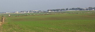
Dortmund Airport in the east of the Dortmund ridge |
||
| Highest peak | Hohe Malterse , near Dortmund Airport ( 146.5 m above sea level ) | |
| part of | Hellwegbörden | |
|
|
||
| Coordinates | 51 ° 31 ' N , 7 ° 36' E | |
The Dortmunder Ridge is a submontane mountain range in the eastern Ruhr area . It extends from the south-eastern city limits of Dortmund to the municipality of Holzwickede over the east of Dortmund and the southern Dortmund city center to the west to the valley of the Emscher.
Naturally , the Dortmunder Ridge (code number 542.20) belongs to the so-called Oberbörden (542.2) of the main unit Hellwegbörden (main unit 542) in the southwest of the latter and in the south of the main unit group Westphalian Bay ( main unit group 42). This is why it is also known as the Dortmund Börde .
location
The Dortmunder ridge joins the Werl-Unnaer Börde at the height of the Dortmund airport on the city limits of Dortmund to Holzwickede near the eastern city limit to Unna and to the Haarstrang south of it on Holzwickeder municipality. It runs through the Dortmund metropolitan area of the eastern suburbs Wickede , Sölde , isopods , Neuasseln , Aplerbeck , Brackel , Stoke and Wambel , the northern slopes of Horde and the southern city with the garden city and urban development on both sides of Westfalendamm and Rheinlanddamm up to the Emschertal in the area of the Schnettker bridge . Its extension is about 15 km in a west-east direction. At the junction with the Haarstrang at the Emscher source , its maximum north-south extension is approx. 4.5 km, further west less than 3.5 km. The national road 1 extends across the east-west distance of the Dortmund back.
Landscape characteristics
The ridge extends the Werl-Unnaer Börde to the southwest and connects to the ridge of the Haarstrang to the west and to that of the Ardey Mountains to the north . While the Oberbörden adjoining to the east, including the Werl-Unnaer, only represent a north-facing roof of the Haar, the Dortmund ridge also falls south to the Witten-Hörder Mulde and to the west to the Emschertal , which here still runs in a south-north direction , which is why it has the characteristic of a mountain spur.
Elevation profile
The Dortmunder Ridge in the east of the Hohe Malterse , above the Holzwickeder districts of Natorp and Rausingen at the confluence of Vincenz-Wiederholt-Straße with Chaussee , reaches its highest independent height at 146.5 m directly at the airport site . It also reaches similar height values roughly at the seam to the Haarstrang near Sölderholz and in the extension to the Ardey near Aplerbecker Mark .
To the west, the elevations towards Dortmund city center drop to 100 m above sea level. NN (eastern abutment of the Schnettker Bridge).
The Emscher
In Holzwickede, district of Dudenroth , the Emscher rises at the junction of the hairline to the southeast slope of the Dortmund ridge ( Herdicker Haar ) . This flows around the ridge in the north of the Witten-Hörder Mulde, initially south in an east-west direction, in order to change its course to the south-west of Dortmund city center to the north and to flank it to the west along with the ridge that flattens to the west.
Adjacent natural areas
The following natural areas border the Dortmund Ridge (unless otherwise documented, all of them belong to the main unit Hellwegbörden ):
- Dortmund Hellwegtal (north)
- Werl-Unnaer Börde (northern extreme east)
- Hair strand with hair height (extreme east) and Herdicker hair (southern extreme east to southeast)
- Ardey Mountains (narrow seam in the eastern south) - Niederbergisch-Märkisches Hügelland , Süderbergland
- Witten-Hörder Mulde (south to west)
- Emschertal (extreme northwest) - Emscherland
Individual evidence
- ↑ a b Martin Bürgener: Geographical land survey: The natural space units on sheet 110 Arnsberg. Federal Institute for Regional Studies, Bad Godesberg 1969. → Online map (PDF; 6.1 MB)
- ^ A b Karlheinz Paffen , Adolf Schüttler, Heinrich Müller-Miny: Geographical land survey: The natural space units on sheet 108/109 Düsseldorf / Erkelenz. Federal Institute for Regional Studies, Bad Godesberg 1963. → Online map (PDF; 7.1 MB)
- ↑ a b Topographical Information Management, Cologne District Government, Department GEObasis NRW ( Notes ) - Basic map 1: 5,000 and water station map can be activated!
literature
- Martin Bürgener: Geographical land survey: The natural spatial units on sheet 110 Arnsberg. Federal Institute for Regional Studies, Bad Godesberg 1969. → Online map (PDF; 6.1 MB)
- Sofie Meisel: Geographical land survey: The natural spatial units on sheet 97 Münster. Federal Institute for Regional Studies, Bad Godesberg 1960. → Online map (PDF; 4.1 MB)


