
Gelsenkirchen-Buer
 district of Gelsenkirchen |
|
|---|---|
 |
|
| Coordinates | 51 ° 34 '40 " N , 7 ° 3' 23" E |
| Residents | 33,730 (Dec. 31, 2013) |
| Incorporation | April 1, 1928 (merging of Buer, Horst and Gelsenkirchen to form the city of Gelsenkirchen-Buer) May 21, 1930 (renaming of the city to Gelsenkirchen) |
| Post Code | 45894 |
| prefix | 0209 |
| structure | |
| Borough | North |
| Districts | |
| politics | |
| District Head | Klasmann, Thomas ( SPD ) |
| Transport links | |
| Highway |
|
| Federal road |
|
| Train | S9 |
| tram | 301, 302 |
| bus | 210, 211, 222, 243, 244, 247, 249, 255, 380, 381, 396, 397, 398, 399, NE2, NE9, NE10, NE11, NE12, NE14, SB23, SB28, SB91 |
| Source: Gelsenkirchen statistical office, Rhein-Ruhr transport association | |
Buer [ buːɐ̯ ] ( Dehnungs-e ) is a district of the independent city of Gelsenkirchen in North Rhine-Westphalia . He, together with the districts Scholven and Hassel the district Gelsenkirchen-Nord .
The district of Buer bears the name of the former city of Buer , founded in 1911 , which - together with Horst - was united with Gelsenkirchen in 1928 (until May 1930 the united city was called Gelsenkirchen-Buer, then Gelsenkirchen). The current part of the city only occupies the core area of the former town of Buer (the area around the old village including the areas of the former farmers' associations Löchter , Bülse and Heege ). The former urban area of Buer was much larger and included all of today's districts of Gelsenkirchen north of the Emscher with the exception of Horst. The three districts of Gelsenkirchen-Nord, Gelsenkirchen-West and Gelsenkirchen-Ost, which are formed by the eight present-day districts north of the Emscher including Horst and historically largely belonged to Buer, make up a little more than half of Gelsenkirchen's residents. Buer is still seen by the population as an “independent old community” based on local color. In addition to the geographical location and historical events, this delimitation is expressed in the size of the town center and the accumulation of upscale residential areas in Buer in relation to the city as a whole.
geography
location
Up to 1928 Buer was independent as " Freiheit " (from 1448) and as the city "Buer in Westphalia" (from 1911). While the boundaries of the Buer area constantly shifted until the middle of the 19th century, at the beginning of the 20th century the location of the then city of Buer including the Horst office can be described as follows: In the south it borders on the independent cities of Herne and Essen . The Rhine-Herne Canal delimited the city of Buer from the city of Gelsenkirchen in the south . In the north it borders on the towns of the Recklinghausen district of Dorsten , Marl or Polsum and Herten and Westerholt . To the west at Gladbeck and Bottrop- Churchhellen.
It should be noted that "Buer in Westphalia" or the Buer office included the current Gelsenkirchen districts of Scholven including Bülse, Hassel , Beckhausen including Schaffrath and Sutum, Resse , Resser Mark and Erle.
The district of Gelsenkirchen-Buer is surrounded by the following districts of Gelsenkirchen: In the north by the districts of Scholven, Hassel, and in the west by the city of Gladbeck in the Recklinghausen district; in the east through the districts of Resse and Erle, as well as the border with the Herten district of Westerholt; in the south through Beckhausen.
Buer is located in the countryside and is surrounded, among other things, by arable land and smaller forest areas. It includes several green zones and parks with ponds and lakes such as Schloss Berge , Berger See, Lohmühlenteich, Hülser Heide, Löchterheide, Stadtwald, the area of the former Löwenpark or the central cemetery Buer-Mitte on Haunerfeldstrasse and Ortbeckstrasse or the old cemetery on Mühlenstrasse , as well as several allotment gardens and sports facilities. Another recreational area is the green and planted Rungenberg waste dump of the former Hugo colliery .
Transport links
Buer has two train stations away from the city center : Gelsenkirchen-Buer Nord on the Hamm-Osterfelder Bahn along with the line towards Haltern . From here, S-Bahn line 9 of the Rhein-Ruhr S-Bahn runs once an hour to Haltern am See station and to Wuppertal via Gladbeck , Bottrop , Essen and Velbert-Langenberg .
At the Gelsenkirchen-Buer Süd station in Gelsenkirchen-Beckhausen , which has been dismantled to a stop , the Emschertal train RB43 also stops every hour on the way from Dorsten via Gladbeck Ost via Wanne-Eickel , Herne , Castrop-Rauxel Süd to Dortmund .
The central hub in local transport in Gelsenkirchen is Buer City Hall in Buer .
There are two motorway connections to the Buer district, in the north to the A52 or the old federal road 224 and in the south to the A2 . The B226 runs through Buer .
history
The municipality of Buer belonged to Vest and the Recklinghausen district before it was granted district freedom and union with Gelsenkirchen, just like Horst . On the history before 1928 Buers see history of previous municipality and city Buer .
With effect from April 1, 1928, the city of Buer with the Horst office and the independent city of Gelsenkirchen were combined to form the new independent city of Gelsenkirchen-Buer. In 1929, the mining trade association founded the Miners' Hospital Bergmannsheil, which merged with the municipal children's clinics to form Bergmannsheil and Buer Children's Clinic in 2002 . On May 21, 1930, the name of the young city was changed to "Gelsenkirchen". Since then, Buer has been run as a district , initially in the sense of expanding the former city of Buer. During the Second World War, the 100 m high tower of the St. Urbanus Provost Church was hit by bombs. Since then it has had a flat roof and is only about 50 m high.
As part of the regional reform in 1975, all independent cities in North Rhine-Westphalia were divided into city districts. In the area of the former city of Buer, the districts of Gelsenkirchen-West, -East and especially -North, with the district of Buer , which only contains the central city center.
In 2003, the first written mention of Buer was commemorated with a grand 1000th anniversary celebration.
population
As of December 31, 2019, there were 33,126 residents in Gelsenkirchen-Buer.
- Share of the female population: 51.8% (Gelsenkirchen average: 50.4%)
- Share of the male population: 48.2% (Gelsenkirchen average: 49.6%)
- Proportion of foreigners: 13.0% (Gelsenkirchen average: 21.7%)
Population development
The following overview shows the population of the Buer district since 2004; for the development of the population of the entire area of the former city of Buer since 1535 see here .
| year | Residents |
|---|---|
| December 31, 2004 | 34,872 |
| December 31, 2005 | 34,877 |
| December 31, 2006 | 34,707 |
| December 31, 2007 | 34,600 |
| December 31, 2008 | 34,308 |
| December 31, 2009 | 34,130 |
| December 31, 2010 | 33,969 |
| December 31, 2011 | 33,917 |
| December 31, 2012 | 33,799 |
| December 31 2013 | 33,730 |
Buildings
See also buildings in Gelsenkirchen
Town hall and town hall tower
The town hall
In 1909 an architectural competition was decided, but all 62 designs were rejected. In mid-1909, the government master builder Josef Peter Heil had to be commissioned with the design and management. His plans were changed again and a large annex was added. Construction began in June 1910 and was inaugurated in September 1912. More than 100 rooms and four conference rooms were created. First mayor was Dr. Carl Russel. In 1952/53 the eastern extension was built. In 1988 the western, old town hall including the tower was placed under monument protection.

- The town hall tower
- Inauguration: September 21, 1912
- Extension: 1952/53
- Renovation: forecourt (2003)
- Architect: Government Builder Heil
- Construction costs: 1.17 million gold marks
- Floors: 6
- Basement (from cassette plaster)
- Basement (made of basalt lava)
- Ground floor (from cassette plaster)
- 1st and 2nd floor (made of cassette plaster)
- Top floor (from cassette plaster)
- Height: 63.72 meters
- Number of levels (total): 278
- Number of steps from the entrance level on the courtyard side: 263
The tower and the paternoster are architectural monuments and can be climbed / used irregularly ( open monument day ). The copper hood is a typical feature of the Wilhelmine era .
Other structures
At the time of the construction of the town hall, 1906–1908, the lyceum ( Leibnizgymnasium ) was built on Breddestrasse. Above the entrance there is the beautiful relief of the green Buerchen Linde, above it the Electoral Cologne Cross, because Buer used to belong to the Archdiocese of Cologne .
The modern Protestant Stephanuskirche on Westerholter Straße rises like the bow of a ship. It was designed in 1964 by the architect Peter Grund , but was only carried out after his death in 1968–1970. The interior design and the abstract concrete glass windows are from the artist Inge Vahle . The small-format altar cross, a blue- ground enamel work, was created according to a design by Elisabeth Grund as a foundation in memory of her deceased husband. The church has been a listed building since 2004 .
Religions
This section mainly covers the 20th and 21st centuries. For prehistory see the Religions section in the article on the former city of Buer .
Catholic community


The area belonged to Werden monastery around 1000 . As early as 1160, the St. Urbanus church was named a "parish church". Today's Sankt-Urbanus-Kirche, with its church tower initially 100 meters high, was built in 1893. The tower was bombed in the Second World War, so that today's tower is only about 50 m high and has had a flat roof since then. Various previous buildings had already been built in the Romanesque style (1302 conversion in the Gothic style) and after a major fire (1688) in the early 18th century.
In 1955, the parish church of Sankt Urbanus was appointed provost church . The then pastor of St. Urbanus, Theodor Lange (born November 26, 1905 in Dortmund, † February 9, 1984) was the first to bear the title of provost . His predecessor Pastor Ernst Roosen (born November 27, 1883 in Essen-Altenessen, † April 30, 1958), who was still living in the parish in retirement at the time, was also appointed provost hc .
A separate deanery in Buer was founded in 1915. In 1954 it was divided into north and south. From January 1, 1958, the Buer deanery was incorporated into the newly founded Ruhr Diocese of Essen .
Due to the increasing number of Catholic immigrants to the Ruhr area at the end of the 19th century, the beginning of the 20th century and the middle of the 20th century because of the influx of refugees and expellees from the formerly German eastern regions and later from the former GDR, the following communities were transferred directly from parish of the original parish of Sankt Urbanus:
- Sankt Barbara (1892) in Erle, daughter communities: Sankt Konrad (1939), Sankt Ida (1948), Sankt Suitbert (1962), Sankt Bonifatius (1959)
- Herz Jesu in Resse (1904), (daughter church: Sankt Hedwig)
- Liebfrauen in Beckhausen (1900), (daughter community: Sankt Clemens in Sutum)
- Sankt Michael in Hassel (1911), (daughter parishes: Sankt Theresia in Hassel, Sankt Pius in Hassel)
- Saint Joseph (1912) in Scholven
- Sankt Ludgerus (1915) (daughter parishes: Heilig Geist (1964) in Schaffrath)
- Christ the King (1954) in Buer (Bergmannsglück)
- Assumption of Mary (1954) in Buer
Due to the shortage of priests in the German Catholic Church, the dwindling number of Catholics in Buer and due to the economic problems of the Diocese of Essen, individual Catholic parishes were merged again between 2000 and 2004 or cooperations were entered into:
- The mother community of Sankt Urbanus merged with the daughter community of Christ King in Bergmannsglück in 2000
- In 2001 the Erler parishes of Sankt Barbara, Sankt Bonifatius, Sankt Ida and Sankt Suitbert merged to form the new parish of Sankt Barbara.
- The parishes of Liebfrauen (Beckhausen) and Sankt Clemens (Sutum) work together.
- The independent parishes of Buers Propstei Sankt Urbanus, Mariä Himmelfahrt and Sankt Konrad also work together.
- In 2004, Sankt Ludgerus (Buer-Süd) merged with Heilig Geist (Schaffrath) to form the parish of Sankt Ludgerus with a subsidiary church of the Holy Spirit.
The parish of St. Urbanus has been merged with the parishes of St. Mary's Assumption in Buer-Mitte, St. Konrad in Middelich, and St. Pius in Hassel, which was decided by the diocese of Essen as part of its structural reform for 2008 and implemented on August 19, 2007 , Herz Jesu in Resse, St. Josef in Scholven, St. Ludgerus in Buer, Hl. Geist in Schaffrath, St. Barbara in Erle , St. Suitbert in Bergerfeld, St. Ida in Resser Mark, Christ the King in Bergmannsglück, St. Michael in Hassel, St. Theresia in Hassel, St. Hedwig in Resse and St. Bonifatius in Erle, the largest Catholic parish in Germany according to the number of their parishioners. With around 40,000 parish members, the new large parish of St. Urbanus is larger than the diocese of Görlitz , which has around 30,000 Catholics.
Evangelical congregations

The former community of Buer consisted mainly of the Catholic denomination. Only with mining (from 1873) and the associated urban growth were other denominations added. On May 4, 1888, the first independent evangelical parish of Buers - today's Apostle Church - was founded on Essener Strasse (today: Horster Strasse). In 1886 the Protestant parish Erle-Middelich was established and the Protestant parish association Horst-Buer was dissolved. In 1906 the Protestant community in Resse was established. In 1911 the Evangelical Christ Church in Beckhausen was built on Bergstrasse. In some parts of the city, subsidiary churches of the above-mentioned Protestant churches were established until the 1960s.
Jewish community
In 1922 a synagogue was built on Maelostraße in Buer , which was burned down by the National Socialists on November 9, 1938 , during the Reichspogromnacht . In place of the synagogue, a municipal indoor swimming pool was later built. Some of the foundations of the synagogue are made visible by paving stones. The rest is covered by the indoor pool. In addition, a large memorial stone and a sign with the inscription " Memorial " remind of the synagogue. Auguste van Pels (1900–1945), friend of the Anne Franks family , who hid in Amsterdam with the Franks, was born in Buer (since 1928 Gelsenkirchen).
Muslim community
The Muslim community in Gelsenkirchen-Buer was founded by first-generation guest workers from Turkey and North Africa in the 1980s. There are three mosques that are financed by associations.
sons and daughters of the town
- Halil Altıntop , Turkish national soccer player
- Hamit Altıntop , Turkish national soccer player
- Tom Angelripper , musician
- Heinz Assmann , politician
- CC Bergius , writer and publisher
- Hubert Berke , painter and graphic artist
- Ludwig Bredenbrock , local writer, journalist, editor of the Buerschen Zeitung
- Eduard Claudius , writer and GDR diplomat
- Jörg Dahlmann , football commentator
- Father Stefan Dartmann SJ, first provincial of the united German provinces of the Jesuit order
- Sebastian Ernst , athlete
- Gerd Faltings , mathematician and recipient of the Fields Medal
- Klaus Farin , writer
- Hermann Fredersdorf , tax officer and party politician
- Peter Hanfland , hematologist, transfusion specialist and university professor
- Josef Harpe , Colonel General in World War II
- Harald zur Hausen , physician, Nobel Laureate 2008
- Norbert Huda , diver
- Hermann Ilaender , politician (CDU), administrative officer and forestry association official
- Alfred Kelbassa , national soccer player
- Willi Koslowski , national soccer player
- Matthias Lemke , political scientist
- Jordan Mai , Franciscan
- Ludwig Marmulla , communist activist, resistance fighter and party functionary (KPD, SED)
- Andreas Maurer , tennis player
- Manuel Neuer , national soccer goalkeeper
- Mesut Özil , national soccer player
- Peter Paziorek , politician
- Auguste van Pels , friend of the Anne Franks family , who hid in Amsterdam with the Franks.
- Heinz Renneberg , rower
- Ulrich Rützel , music producer and publisher
- Bernhard Sann , Rector of RWTH Aachen
- Claus Schiprowski , athlete
- Hermann Steinkamp , Roman Catholic theologian
- Rudolf Schwietering , national volleyball team for the disabled, 3 times Paralympics gold
- Theo Uppenkamp , soccer player
- Fritz Vahrenholt , politician (SPD), author and manager.
photos
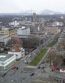
The view in all four directions from the Buerer town hall tower:
1955

to the north

to the east

to the south

to the west


2005
to the north

to the east

to the south

to the west


literature
- Buersches Lesebuch - 1000 years Buer 1003–2003 . Ed. Association for Local and Local History eV Gelsenkirchen-Buer, Gelsenkirchen 2002.
- Contributions to the history of the city - 1000 years of Buer . Volume XXIII, Association for Local and Local History eV Gelsenkirchen-Buer, Gelsenkirchen 2003.
- Kira Schmidt (Ed.): Kicker, Kumpel, Kohlrouladen - A Buersches Bergbau-Lesebuch . Beluga New Media publishing house, Gelsenkirchen 2006, ISBN 3-938152-10-9 .
- Dietmar Ahlemann: The Lords of Buer - A West German Family History from the High Middle Ages to the 19th Century. In: West German Society for Family Studies eV (Ed.): Yearbook 2012, Volume 274, Cologne 2012, pp. 213-300.
- Karl Machtan: The story of those von Buer. In: Contributions to the history of the city (Gelsenkirchen-Buer). Volume 7, Gelsenkirchen-Buer 1973, pp. 5-10.
Web links
- The Gelsenkirchen-Buer district
- Heimatverein Buer / Association for local and local history Buer eV
- Views of Buer in Westphalia from five decades
- Gelsenkirchen-Buer in the Westphalia Culture Atlas
Individual evidence
- ↑ a b Stephanie Reekers: The regional development of the districts and municipalities of Westphalia 1817 - 1967 . Aschendorff, Münster (Westphalia) 1977, ISBN 3-402-05875-8 .
- ↑ Population structure in Gelsenkirchen as of December 31, 2019 - data source: City of Gelsenkirchen - opendata.gelsenkirchen.de
- ↑ Population structure in Gelsenkirchen as of December 31, 2019 - data source: City of Gelsenkirchen - opendata.gelsenkirchen.de
- ↑ Population structure in Gelsenkirchen as of December 31, 2019 - data source: City of Gelsenkirchen - opendata.gelsenkirchen.de
- ↑ Share of foreigners in Gelsenkirchen as of December 31, 2019 - Data source: City of Gelsenkirchen - opendata.gelsenkirchen.de
- ↑ Current population statistics ( memento of the original from November 6, 2014 in the Internet Archive ) Info: The archive link was automatically inserted and not yet checked. Please check the original and archive link according to the instructions and then remove this notice. , City of Gelsenkirchen (PDF; 330 kB)
- ↑ Buer Rathaus on gelsenkirchen.de
- ↑ Overview sheet
- ↑ http://www.heimatverein-buer.de
- ↑ http://www.kirchegelsenkirchen.de/infos/unsere-kirchen/stephanuskirche.html
- ↑ Auguste van Pels, née Röttgen, does not come from Buer near Melle, but from Buer near Gelsenkirchen

Old town | Beckhausen | Bismarck | Buer | Bulmke cases | Alder | Feldmark | Hassel | Hessler | Horst | Neustadt | Resse | Resser Mark | Rotthausen | Schalke | Schalke-Nord | Scholven | Ückendorf