
Čiovo
| Čiovo | ||
|---|---|---|
| Waters | the Adrian Sea | |
| Geographical location | 43 ° 30 ' N , 16 ° 18' E | |
|
||
| length | 15.3 km | |
| width | 3.5 km | |
| surface | 28.12 km² | |
| Highest elevation |
Rudine 220 m |
|
| Residents | 4455 (2001) 158 inhabitants / km² |
|
| main place | Trogir | |

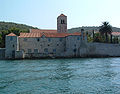
Čiovo [tschi'owo] (Italian Bua ) is a Croatian island in the Adriatic Sea off the coast of central Dalmatia west of Split at the western exit of the Bay of Kaštela . The island is about 15.3 km long and up to 3.5 km wide. The highest point on the island is Rudine with a height of around 220 m. The pilgrimage church Prizidnica on the east side of the island, which was built directly into the rock, is worth seeing .

In the northwest the island is connected to the city of Trogir by a bascule bridge (no longer used for shipping). For a long time this was the island's only connection to the mainland. A new bascule bridge, about 550 m long, was opened a little east of it on July 17, 2018 and significantly relieves traffic. Since there were regular traffic bottlenecks to and from the mainland before, an ambulance was set up on the island in 2016.
In addition to part of the city of Trogir, there are six other villages on the island : Slatine , Arbanija , Mastrinka , Žedno , Okrug Gornji and Okrug Donji . A total of around 6000 people live on the island.
Contrary to popular belief that the island's name stems from a dispute and therefore means “Whose is it?” (Croatian: “Čije je ovo?”), Čiovo is derived from the Latin caput Iovis , which means “ Head of Jupiter ”.
The Romans called the island Bavo , Boa , Boae or Bua . It is mentioned by Pliny ( Naturalis historia 3.26). In the imperial era it served as a place of exile.
Arbanija

Okrug Gornji


Web links
Individual evidence
- ↑ Čiovo Bridge Opened. Retrieved October 6, 2019 (UK English).