Brač
| Brač | ||
|---|---|---|
| Waters | the Adrian Sea | |
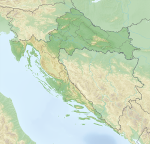
| Geographical location | 43 ° 19 ′ N , 16 ° 40 ′ E | |
|
|
||
| length | 40 km | |
| width | 12 km | |
| surface | 395.44 km² | |
| Highest elevation |
Vidova Gora 778 m |
|
| Residents | 14,031 (2001) 35 inhabitants / km² |
|
| main place | Supetar | |
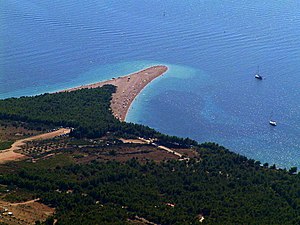
| The Golden Horn near Bol | ||
Brač ( Latin Bretia , Italian Brazza , German earlier Bratz ) is the largest island in Dalmatia with about 40 km in length and 12 km in width. With an area of 395 km² it is the third largest island in the Adriatic . It is separated from the mainland by the Brač Canal (kr. Brački kanal ), which is up to 78 meters deep. On the western side are the island of Šolta and the strait Splitska vrata, to the south there is the island of Hvar and the up to 91 meters deep strait of Hvar (Hvarski kanal).
The island is made of limestone that was formed 100 million years ago in the Cretaceous but only became an island in the Holocene . The erosion and sedimentation caused the formation of other types of soil, so that today you can find limestone, sandstone , breccia (gravel), clay mineral and terra rossa (limestone red loam). The highest point, the Vidova Gora , is also the highest point in the Adriatic (778 meters).
Surname
The origin of the name of the island is still unclear. It is believed that he by the Illyrian Brentos originated (Hirsch), he of the ancient Greeks Elaphusa was called ( elaphos - Hirsch). The Greek historian Polybius and Pliny the Elder mentioned her as Brattia in their writings. The island can be found in the map of Claudius Ptolemy from the 2nd century as well as Iñs. Brattia on the Tabula Peutingeriana from the 4th century .
climate
The island has a Mediterranean climate with an average of 134 sunny days per year. The mild and rainy winters with an average temperature of 9 ° C and hot and dry summers with an average of 25 ° C are characteristic of the climate. But there is also a significant climatic difference between the coastal areas and areas at over 500 meters above sea level. The sea water temperature is 22 ° C in the summer months. The seasonal temperature differences are moderate due to the influence of the sea. The mild Maestral (Maeštral) wind provides refreshment in summer from midday.
The Bura and Jugo winds are also characteristic . The Bura is a cold and gusty north wind whose gusts can reach top speeds of up to 200 km / h. The Jugo or Scirocco is a hot and humid wind that blows from the southeast, from the Sahara towards the Mediterranean . The wind mostly brings cloudy and rainy weather with it. In the interior of the island and on the eastern side there is more precipitation (1400 mm) than in the coastal area (700 mm). The vegetation is conditioned by the climate . The holm oaks , the indigenous Aleppo pine , Scots pine and black pine predominate .
population
According to the last census of 2011, the island of Brač has 14,434 inhabitants. In the Middle Ages, the Illyrian- Roman population decreased more and more. The new inhabitants were Narentans and Croats . The most widely spoken dialect is Čakavisch in its various versions (Čakavisch, Čokavisch) in the east of the island of Štokavisch .
The island's inhabitants are predominantly Catholic Croats. They live in small towns. The most important place with just over 3200 inhabitants is Supetar . During the summer, the ferries arrive here every hour (less often in the winter months), and they take about an hour to cross from the mainland. Another ferry port is Sumartin , which connects the island with Makarska . The smallest settlement on the island is Murvica with 22 inhabitants. The most popular tourist attractions are Bol (see Vidova Gora ) and the oldest settlement Škrip .
The island is divided into a 'city' (a Croatian type of municipality with an urban center) and seven municipalities. The city and parishes comprise the island's 22 inhabited settlements. The population figures in the following list are from the 2011 census.
- City of Supetar (4074 Ew.) With the places Mirca (321), Splitska (368), Škrip (172), and the actual Supetar (3213)
- Municipality of Bol (1630 Ew.) With the places Bol (1609) and Murvica (21)
- Municipality of Milna (1034 Ew.) With the places Bobovišća (65), Ložišća (139), and Milna (830)
- Municipality of Nerežišća (862 Ew.) With the places Donji Humac (157), Dračevica (89), and Nerežišća (616)
- Municipality Postira (1559 Ew.) With the villages of Dol (130) and Postira (1429)
- Municipality Pučišća (2171 Ew.) With the places Gornji Humac (271), Pražnica (371), and Pučišća (1529)
- Municipality of Selca (1803 Ew.) With the places Novo Selo (152), Povlja (332), Selca (846), and Sumartin (474)
- Municipality of Sutivan (822 Ew.), With the same place
history
Archaeological excavations have shown that already in the Paleolithic on Brač there were people who lived in communities (Kopačina cave between Supetar and Donji Humac). It is surprising that there are no other finds from the Neolithic period . In the Bronze and Iron Ages , the island was populated by the Illyrians , who mainly settled in the interior of the islands. Many of their buildings are still preserved today (council near Ložišća, Velo Gra… near Selca and Koštilo near Bol).
In the 4th century BC The Greeks founded many colonies in Dalmatia (e.g. Issa - Vis island, Tragurion - Trogir, Epetium - Stobrec), but no traces of this period have been found on the island of Brač. The Greeks apparently only came as visitors, especially in the port of Vicja Luka near Ložišća , where Greek objects were found. The island of Brač was on the mainland trade route between the island of Issa and Salona , and Vičja luka was a stop on this route.
After numerous battles, the Romans broke the Delmatian resistance in 9 AD. The province of Dalmatia was founded. Their capital was Salona. The island of Brač was not settled, presumably because Salona was not far away. Traces of the Romans have nevertheless been found everywhere (Villa Rusticae, collecting wells, animal drinking troughs, olive and wine presses, sarcophagi, remains of the moorings in Splitska, Bol, Lovrečina).
After the destruction of Salona by the Avars and Slavs , many refugees sought protection on the island. Shortly thereafter, Slavs began to colonize the island. Salonites founded the Škrip settlement. Politically, the island was part of the Byzantine Empire .
In the 12th century, King Koloman of Hungary became King of Croatia through an agreement with the Croatian nobility (pacta conventa) in personal union (see article Kingdom of Hungary ). The island of Brač retained its independence until 1268. From then until 1357 the island was under the government of the Republic of Venice . It then became part of the Austro-Hungarian Empire , but always retained its communal autonomy. Between 1410 and 1420, the Venetians managed to conquer all of Dalmatia with the exception of the Republic of Ragusa . The Venetian rule over the island of Brač lasted until 1797. After the fall of the Republic of Venice, the island was under French rule (1805-1813). After the Congress of Vienna in 1814/1815, all of Dalmatia reverted to Austria-Hungary.
In the spring of 1941, troops of fascist Italy occupied the island. A year later, anti-fascist groups of the people's liberation formed everywhere and put up fierce resistance. The violent clashes culminated in numerous executions and the burning down of the towns of Selca, Novo Selo, Gornji Humac, Pražnica, Pučišća, Dračevica and Bol, with a great fire raging in Selca that was even described in songs. After the capitulation of Italy in 1943, the population disarmed the troops and liberated the island for a few months until the Ustaša arrived in October 1943. In the spring of 1944, the island was occupied by German troops. In the same year, Yugoslav partisans and special forces of the Allies conquered the island of Brač.
Culture
In the early Middle Ages , Croatians and Narentans populated the island. Numerous chapels that can be found in the interior of the island date from this time. During this time the island also had several monasteries. A statute organized the life of the population between the 13th and 18th centuries and says a lot about the social and cultural development of that time. The palaces of the nobility, but also the simpler architecture, bear witness to a highly developed living culture. Mention should also be made of the Blaca Hermitage , one of the seven locations that the Republic of Croatia proposed to the World Heritage Committee for inclusion on the UNESCO World Heritage List .
During the Renaissance all of Dalmatia was in its prime. The quarries on the island attracted numerous artists, architects and builders, including Juraj Dalmatinac , Andrija Alesi , Nikola Firentinac . Her work can be found all over the island.
Postira is a small place on the north side of the island. In the last 50 years important archaeological finds have been made there, which show that there was an organized life in the place as early as the first century AD. In addition to the parish church in 1988 took place during the work on the sacristy a three-aisled early Christian church from the first half of the 6th century comes and still in the 7th century was used.
The official language on the island was Latin , the colloquial language Croatian . The script was Bosančica . The Povaljska Listina (Povaljer List) from 1184, the oldest and most important document of medieval Brač, was also written in the script. In the Middle Ages , the population lived from animal husbandry , forestry , agriculture , fishing , the quarry and trade .
economy
Brač lives mainly from tourism , also from fishing and agriculture (especially wine and olives ) and the mining of high-quality stones.
Due to strong migration all over the world, especially in the 20th century, many houses are empty today. Since the construction of an airport near Bol, there has been hope for economic stabilization.
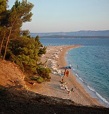
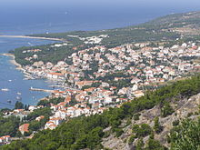
Bol is considered the tourist center of Brač. In the immediate vicinity of the village is the Golden Horn , which is often referred to as the most beautiful beach in Croatia.
The most impressive vineyards on the island of Brač are located on their southern slopes above the village of Bol. The wine is grown here on small terraces. The dark red Bolski Plavac is characterized by its pleasant bitterness and its specific bouquet.
In the Vidova Gora, part of the central plateau of the island, grows a forest of autochthonous Dalmatian black pines, from which resin was extracted a long time ago . The scars resulting from this traditional activity, which is now extinct, can still be seen in the tree bark today.
Brač is known for its white limestone , which is located under the soil cover that has become very thin due to soil erosion in recent centuries. The limestone gets its typical white color from the composition of the mineral dolomite and the shells of marine organisms. The quality of the rock was already known to the Romans , who used it to build cities, amphitheaters , temples , palaces and tombs in Dalmatia .
Limestone from the island of Brač was found on the Palace of Diocletian in Split , on the medieval bell towers and cathedrals of Šibenik and Trogir , the White House in Washington, DC , the Parliament and the New Hofburg in Vienna , the Budapest Parliament and the Governor's Palace in Trieste built .
Several types of natural stone are mined on Brač. The most important quarries can be found in the coastal zone, because in the past centuries the removal of the blocks and workpieces made available was made easier by the landing of ships. In the southern village of Pučišća there is a stonemason school with a long tradition. It represents the legacy of significant stone processing in Dalmatia. In 1902 stonemasons founded the "First Dalmatian Stonemason Cooperative". As a result, an increased need for training developed in a short time, which led to the establishment of a training center. Some quarries are located in the south of the island.
Flora and fauna
In July 2019 there was an increased incidence of the octopus (Tremoctopus violaceus), which is very rare in the Adriatic , in the area of the Croatian islands of Hvar , Brač and Šolta . An increased occurrence of the blanket octopus in Dalmatia was last reported in 1936. Characteristic of this octopus is the enormous difference in size between females (up to 2.5 meters) and males (only 2.4 centimeters).
folklore
According to legend , snow fell on August 5th in the town of Bol on the sparsely populated south side of the coast. Since then, the feast of Our Lady of the Snow has been celebrated here. To this day, the carnival has remained the event at which the population masks themselves. There used to be masks on various occasions, at religious festivals (St. Nicholas and the " Crampus ", St. Luzia and Christmas ), at weddings and at Mardi Gras. A special feature included masks made from the skin of a ray. Funny short stories (gončice) are also a feature of the island. The writer Vuk Stefanović Karadžić published the story of the dragging of the small island Mrduja , which lies between the island of Brač and the island of Šolta , in his collection of traditional folk stories.
The poet Vladimir Nazor, who is very famous in Croatia, was born in Postira on Brač in 1876 . He was one of the most prolific Croatian writers and published numerous poems , ballads , epics , short stories , novels and essays . In his novel Pastir Loda (The Shepherd Loda) he tells stories from his island.
The inhabitants of Brač are often characterized as stingy in Croatian jokes , similar to the Swabians or Scots .
Churches
Little is known to most tourists the large number of early Christian and early Croatian churches, which are spread over the entire island - mostly in impassable areas and unsigned. Among the more accessible are the early Christian religious centers of Povlja (remains of a large basilica from the 6th century next to the parish church) and Lovrecina (ruins of a church from the 5th / 6th century) in the bay of the same name east of Postira. The Jadro Church (6th century) on the road between Splitska and Skrip and the early Christian mosaics north of the Parish Church of Supetar are also easy to find .
The mostly very small old Croatian churches from the 8th to 11th centuries are even more hidden - only Sv. As such, Duh in Skrip is indicated by a sign. The Michael Church of Donj Humac (built in the 9th century from the remains of a Roman mausoleum, 2 km west of the village) and the tiny Church of Sv. Juraj above the road to Postira. About 20 to 30 other churches, the construction of which dates back to before the year 1000, can only be reached with the help of topographical maps and long hikes.
Personalities
- Nikola Eterović : Apostolic Nuncio in Germany since 2013
- Vladimir Nazor , writer (1876–1949)
- Branislav Dešković , sculptor (1883–1939)
- Dasen Vrsalović , archaeologist (1928–1981)
- Ivan Rendić , sculptor (1849–1932)
- Žan Jakopač , musician
- Ivica Jakšić - Puko , artist
- Stjepan Pulišelić , writer
See also
literature
- Dasen Vrsalović: Povijest otoka Brača Povijest Dalmacija i Boka Kotorska. 1968.
- Andre Jutronić: Naselja i porijeklo stanovništva na otoku Braču (Zbornik za narodni život i običaje 34). Zagreb 1950.
- Josip Milićević: Folk life and customs of the island of Brač. 1975.
- Dunja Rihtman-Šotrić: The traditional folk music of the island of Brač. (based on 469 examples collected in 1969)
- Kristina Jelinčić, Ljubica Perinić Muratović: Novi arheološki nalazi iz Postira na otoku Braču - New archaeological finds from Postira on the island of Brač. Hrvatska akademija znanost i umjetnosti, Odsjek za arheologiju, Zagreb 2010, pp. 177–216. ( online , PDF) (near Postira there was a temple of Venus and a medieval cemetery)
- Znanstvena biblioteka Hrvatskog filološkog društva. Zagreb 1988, pp. 222-226.
Web links
- Popis 2011 - Jer Zemlju čine ljudi, Statistical Report. (PDF; 2.38 MB) Croatian Statistical Bureau, June 15, 2011, accessed on March 18, 2014 .
- Information about the island
Individual evidence
- ↑ Tea Duplančić Leder, Tin Ujević, Mendi Čala: Coastline lengths and areas of islands in the Croatian part of the Adriatic Sea determined from the topographic maps at the scale of 1: 25,000 (PDF; 378 kB). In: Geoadria. Volume 9, No. 1, 2004, pp. 5-32.
- ↑ Konrad Mannertaus: Geography of the Greeks and Romans from their writings: Thracia, Illyria, Macedinien, Thessaly, Epirus.
- ↑ amshistorica.unibo.it
- ↑ tabula-peutingeriana.de ( Memento of the original from September 24, 2015 in the Internet Archive ) Info: The archive link was inserted automatically and has not yet been checked. Please check the original and archive link according to the instructions and then remove this notice.
- ↑ dzs.hr
- ↑ mdc.hr
- ↑ enciklopedija.hr
- ↑ D. Balen-Letunic: Nalaz ratnicke opreme, VAMZ, p. 3, XXIV-XXV 21-34 (1991-1992) 21, Arheoloski muzej u Zagrebu.
- ↑ plekos.uni-muenchen.de
- ↑ Harald Heppner: Capitals between Save, Bosporus and Dnieper: History - Function - National Symbolism.
- ^ Britannica.com
- ↑ min-kulture.hr
- ↑ Dragica Malić, Povaljska listina kao jezični spomenik, Znanstvena biblioteka Hrvatskog filološkog društva, Zagreb 1988: 222-226.
- ↑ WISEGeek - knowledge database. What is so Special About Croatian Limestone ?. Retrieved June 15, 2016.
- ↑ articles.sun-sentinel.com
- ↑ Lauren Simmonds: Rarely Seen Octopus Appears in Adriatic Near Hvar, Brač and Šolta. July 21, 2019, accessed on August 14, 2019 .


