
Olib
| Olib | ||
|---|---|---|
| Waters | the Adrian Sea | |
| Geographical location | 44 ° 22 '2 " N , 14 ° 47' 3" E | |
|
||
| length | 9 km | |
| width | 6.5 km | |
| surface | 25.63 km² | |
| Highest elevation |
Kalac 74 m. i. J. |
|
| Residents | 140 (2011) 5.5 inhabitants / km² |
|
| main place | Olib (place) | |

Olib (German: Lüb ) is an island in the Croatian region of Dalmatia . It is located in the Adriatic Sea in the Zadar archipelago , four nautical miles (port-port) east of the island of Silba and ten nautical miles southeast of Novalja ( Pag ).
General
The island has an area of 25.63 km², the highest elevations are the elevations Kalac (74 m) and Poljine (34 m). Its maximum dimensions are 9 km in north-south direction and 6.5 km in east-west direction.
Olib is made up of limestone rocks, so the water supply is very limited - there are neither surface watercourses nor permanent water-bearing springs on the island. As is usual in the region, however, there are rain-fed waterholes and man-made cisterns . The whole island is overgrown with bushwood, in the west, protected from the bora , the vegetation is lush, holm oak and macchia grow here . The only village of the same name on the island of Olib is located in a large bay in the west of the island.
population
The island was first mentioned in a document in the 10th century. Croatians from Vrlika colonized the island towards the end of the 15th century when they fled from invading Ottomans .
Olib currently has 140 permanent residents (for comparison: in 1920 there were 2000). This number doubles or triples in the summer months, as many Croatians in exile - especially from the USA - visit their home island at this time. On Olib is chakavian spoken.
Attractions
In the bay of Banve lie the foundations of buildings from Roman times and the ruins of the St. Paul's Church with a monastery that was abandoned and destroyed around 1200.
In the center of the village of Olib there is a completely preserved 400 year old watchtower. This was built to protect the island from Senyan pirates. The tower is the symbol of the island and is also shown on its coat of arms (flag).
Nautical
The east coast of Olib with the bays Slatina and Slatinica is not suitable for anchoring because of the wind, the bora and because of the individual shoals.
The port of Olib can accommodate larger ships. Ships of the regularly operating lines anchor at the outer part of the pier, which closes the port on the northwest side. The inner pier offers space for approx. 15 yachts.
Also, the open west Außenmole is expanded for mooring ( Moorings ). However, mooring at the outer pier is not advisable due to sudden hurricane-like westerly winds - especially in midsummer ( Nevera ). Once the Nevera has entered the port, it is usually impossible to leave the port.
In 2005 and 2006 a new pier was built across the old pier head. However, this does not represent any protection from Nevera, as the outer pier is still open to the west.
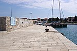
The port of Olib
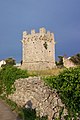
Watchtower on Olib

Construction work on the outer pier in spring 2006

Completed extension of the pier in Olib


Web links
- Welcome to Olib-Silba.com ( Memento from July 22, 2012 in the Internet Archive )
