
Cres
| Cres | ||
|---|---|---|
 |
||
| Waters | Adriatic Sea , Kvarner | |
| Geographical location | 44 ° 53 ' N , 14 ° 24' E | |
|
||
| length | 66 km | |
| width | 12 km | |
| surface | 405.78 km² | |
| Highest elevation | Gorice 648 m |
|
| Residents | 3184 (2001) 7.8 inhabitants / km² |
|
| main place | Cres (city) | |
 |
||

The island of Cres [ tsrɛs ] (Italian Cherso , German outdated Kersch ) is together with the island of exactly the same size Krk the largest island in the Adriatic . It is located in the northern part of the Kvarner Bay in front of the Istrian peninsula and belongs to the Primorje-Gorski kotar County in Croatia .
geography
Cres is a mountainous island, 66 km long and 2 to 12 km wide. The length of the coast is around 248 km.
The highest peak on the island is Gorice (648 m). The freshwater lake Vrana (5.75 km²; German about: crow ) is a cryptodepression , the lake floor is at a depth of 74 m below the sea surface, while the surface of the lake is higher than that of the surrounding sea. The entire mountain slopes around Lake Vrana are restricted area, only a few locals are allowed access to the lake shore, because the entire island's drinking water needs are covered by Lake Vrana.
By a swing bridge is the island in its southern part, in Osor , with the island Lošinj connected.
The largest town is the town of the same name, Cres, with 2,234 inhabitants.
There is a colony of wild griffon vultures on the island .
history
The island of Cres was inhabited as early as the Neolithic Age. The first Croats settled on the island in the early 7th century (see Landing of the Slavs in the Balkans ). From the 16th century to 1797, Cres, like the neighboring islands, was under Venetian rule.
After the fall of Venice, the Habsburgs took control of the eastern Adriatic coast and thus also of Cres. Between 1805 and 1814, Cres was briefly part of France , later part of the Danube Monarchy ( Austria-Hungary ). Finally, the island came to Italy with the signing of the Treaty of Rapallo on November 12, 1920 . During the Second World War, the island was occupied by German troops . After the end of the war, it became part of the Republic of Croatia within Yugoslavia and after Croatia's independence in 1991 it remained part of the Republic of Croatia.
The largest population group of the islanders are Croatians , followed by Bosniaks , Serbs , Slovenes and small populations of Italians and Germans .
Locations on the island
(Sequence analogous to the direction of travel on Inselstrasse (Bundesstrasse 100) from north to south)
- Ivanje
- Porozina (ferry from Brestova in Istria)
- Filožići
- Dragozetići
- Beli , Sveti Petar
- Predošćica
- Vodice
- Merag (ferry from Valbiska on Krk )
- Cres (island capital)
- Loznati
- Valun , Mali Podol , Pernat, Zbičina, Lubenice
- Orlec
- Vrana
- Hrasta
- Stivan, Miholašćica, Zaglav, Martinšćica, Vidovići
- Belej (dt. Outdated: Kaißol)
- Ustrine
- Osor (German outdated: Opsor) (bridge on Lošinj )
- Punta Križa
transport
The island of Cres can be reached by ferry from Brestova (mainland Istria) to Porozina (island of Cres) and from Valbiska (island of Krk) to Merag (island of Cres). Furthermore, pedestrians can reach the ports of Cres and Martinšćica by catamaran from Rijeka on the Mali Lošinj - Rijeka - Mali Lošinj line.

Personalities
- Francesco Patrizi da Cherso (Frane Petrić, 1529–1597), philosopher
- Mate Solis (1935–2019), Croatian artist, born in Zadar, grew up on Cres
literature
- Ernst Mayer : Lake Vrana on the island of Cherso in the Adriatic Sea . In: Moritz Alois Becker (Red.): Communications from the Imperial and Royal Geographical Society Vienna . Volume 16.1873 (NF 6). Hölder, Vienna 1874, pp. 241–248. - Full text online .
photos

Beli
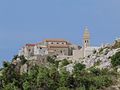
Lubenice


Individual evidence
- ↑ Geographic location i meteorološki Podaci (geographical and meteorological data). Državni zavod za statistiku (Croatian Statistical Office), 2005 (PDF; 139 kB)