
Koločep
| Koločep | ||
|---|---|---|
 |
||
| Waters | the Adrian Sea | |
| Archipelago | Elaphites | |
| Geographical location | 42 ° 40 '35 " N , 18 ° 0' 24" E | |
|
||
| surface | 2.44 km² | |
| Highest elevation | Križ 125 m |
|
| Residents | 163 (2015) 67 inhabitants / km² |
|
| main place | Gornje Čelo | |
 |
||

Koločep or Kalamota is an island in the Croatian County of Dubrovnik-Neretva and part of the Elaphite . To the west of the island is Lopud . At the narrowest point of the Koločep Canal, the distance to the mainland is 1 km.
General
The island is home to two settlements: Gornje Čelo and Donje Čelo . The settlements are connected by a street, but due to the lack of width, no motor vehicles can travel on it, so the street serves as a purely pedestrian path. The island is regularly served by the shipping company Jadrolinija and is connected to Dubrovnik through this . The population is mainly made up of Croatians , who mainly live from tourism in the high season and from fishing. There is a hotel for married couples on the island, but many locals offer apartments.

Donje Čelo Church
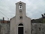
Gornje Čelo Church

Road between places

Cliff
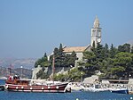
The neighboring island of Lopud
.JPG)


