
Supetar
| Supetar | |||
|
|||
|
|||
| Basic data | |||
|---|---|---|---|
| State : |
|
||
| County : |
|
||
| Island : | Brač | ||
| Height : | 0 m. i. J. | ||
| Area : | 30.00 km² | ||
| Residents : | 4,074 (2011) | ||
| Population density : | 136 inhabitants per km² | ||
| Telephone code : | (+385) 021 | ||
| Postal code : | 21 400 | ||
| License plate : | ST | ||
| Boat registration : | SU | ||
| Structure and administration (status: 2013, cf. ) |
|||
| Community type : | city | ||
| Mayor : | Ivana Marković ( SDP ) | ||
| Postal address : | Porat 3 21 400 Supetar |
||
| Website : | |||


Supetar [ ˈsupɛtar ] (Italian: San Pietro della Brazza ) is a municipality and the only town on the island of Brač in Croatia .
History and location
Supetar is located on the northern side of the island in the bay Sveti Petar (Eng. Saint Peter ), which gave the place its name. A little more than 3200 people live in the city (2011).
Early Christian mosaics from the 6th century have been preserved near the church . The place was already settled in the time of the Romans . Later the Illyrians and Slavs followed . On the foundation of the first church, the Sveti Petar Church was built in 1604, which later fell victim to the fire. The church that exists today was built in 1733. Next to the church is the magnificent town hall. Toma Rosandic (1878–1958), a well-known Croatian artist, designed a mausoleum for a wealthy family in 1904 . This oversized structure is in the Cape Sveti Nikolaus cemetery. The main source of income today is tourism . Supetar is the main ferry port for connecting the island with mainland Croatia, especially to Split .
Places in the municipality of Supetar
Population according to the 2011 census:
gallery
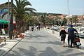
Waterfront promenade in Supetar
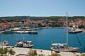
port


Web links
- Official website of the city of Supetar
- Supetar on the Supetar City Tourist Board website
- Website about Supetar in German
Individual evidence
Cities: Hvar | Imotski | Kaštela | Komiža | Makarska | Omiš | Sinj | Solin | Split | Stari Grad | Supetar | Trilj | Trogir | Vis | Vrgorac | Vrlika
Municipalities: Baška Voda | Bol | Brela | Cista Provo | Dicmo | Dugi Rat | Dugopolje | Gradac | Hrvace | Jelsa | Klis | Lećevica | Lokvičići | Lovreć | Marina | Milna | Muć | Nerežišća | Okrug | Otok | Podbablje | Podgora | Podstrana | Postira | Prgomet | Primorski Dolac | Proložac | Pučišća | Runovići | Seget | Selca | Sućuraj | Sutivan | Šestanovac | Šolta | Tučepi | Zadvarje | Zagvozd | Zmijavci