Brela
| Brela | ||
|
||
|
|
||
| Basic data | ||
|---|---|---|
| State : |
|
|
| County : |
|
|
| Height : | 0 m. i. J. | |
| Area : | 20.00 km² | |
| Residents : | 1,703 (2011) | |
| Population density : | 85 inhabitants per km² | |
| Telephone code : | (+385) 021 | |
| Postal code : | 21 322 | |
| License plate : | MA | |
| Structure and administration (status: 2013, cf. ) |
||
| Community type : | local community | |
| Mayor : | Stipe Ursić ( HDZ ) | |
| Website : | ||
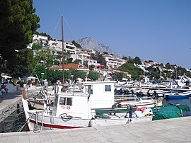
 View of Brela |
||
Brela is a village in Dalmatia ( Croatia ) with 1703 inhabitants (2011). It is located on the Croatian coast on the Makarska Riviera , about 15 km northwest of the city of Makarska , between the Biokovo Mountains and the Adriatic Sea . The white pebble beaches of Brela, which are lined with pine trees, are characteristic of the place. The town's landmark is the Brela stone in front of Punta Rata beach. Name-giving and characteristic of the area around Brela are the submarine springs , which gush into the sea near the coast below sea level. These springs (Croatian vrelo ) create eddies (Croatian vrulja ) on the sea surface. The water comes from the Biokovo Mountains. Brela is located directly on the Adriatic highway .
Web links
Commons : Brela - collection of pictures, videos and audio files


