Komiža
| Komiža | ||
|
||
|
|
||
| Basic data | ||
|---|---|---|
| State : |
|
|
| County : |
|
|
| Island : | Vis | |
| Height : | 0 m. i. J. | |
| Area : | 48.00 km² | |
| Residents : | 1,526 (2011) | |
| Population density : | 32 inhabitants per km² | |
| Telephone code : | (+385) 021 | |
| Postal code : | 21 485 | |
| License plate : | ST | |
| Boat registration : | concentration camp | |
| Structure and administration (status: 2013, cf. ) |
||
| Community type : | city | |
| Mayor : | Tonka Ivčević ( SDP ) | |
| Postal address : | Ulica hrvatskih mučenika 9 21 485 Komiža |
|
| Website : | ||
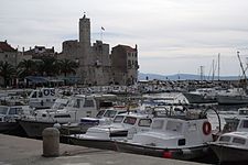
Komiža (Italian Comisa ) is a small Croatian town with a port on the west coast of the island of Vis in the Adriatic Sea . It belongs to the Split-Dalmatia County and is about 10 kilometers from the city of Vis .
The settlement was first mentioned in a document in the 12th century. The port citadel was built in 1585. Komiža is located at the foot of Mount Hum (587 m). Komiža has a regular catamaran connection with Split and two road connections with the city of Vis. The economy is based on viticulture, fishing and tourism.
The island of Biševo also belongs to the Komižas municipality .
Famous pepole
Web links
Commons : Komiža - collection of images, videos and audio files


