
Gradac (Croatia)
| Gradac | |||
|
|||
|
|||
| Basic data | |||
|---|---|---|---|
| State : |
|
||
| County : |
|
||
| Area : | 49.00 km² | ||
| Residents : | 3,261 (2011) | ||
| Population density : | 67 inhabitants per km² | ||
| Telephone code : | (+385) 021 | ||
| Postal code : | 21 330 | ||
| License plate : | MA | ||
| Structure and administration | |||
| Community type : | local community | ||
| Mayor : | Matko Burić ( SDP ) | ||
| Website : | |||


Gradac is a municipality with 3,261 inhabitants (2011 census) in the Split-Dalmatia County in Croatia .
The municipality of Gradac also includes the northern villages of Drvenik (with a ferry port to the island of Hvar ), Zaostrog , Podaca and Brist . It is located almost exactly between Split and Dubrovnik . Gradac is the southernmost place on the Makarska Riviera and is known for the longest beach in this region, which stretches for about six kilometers.
geography
The center of Gradac lies on a small headland, with long pebble beaches stretching on both sides. South of the headland, the town center stretches along the Vodice Bay with its promenade. The Bosac bay with its beach promenade begins north of the headland. This promenade extends past the Hotel Labineca to the towns of Brist and Podaca.

Gradac

Gradac port.
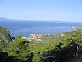
View of Gradac

Čista


history
The place was previously mentioned as Labineca and it was located away from the sea on a mountain slope. A fortress, which was here about 300 years ago, gave the place its current name.
In many Slavic languages, "Grad" means castle or fortress. Gradec (or Gradac) is a small fortress. One of the better known examples of this is the city of Graz (Austria) which was originally a Slavic settlement.
At the beginning of the 20th century, Gradac was integrated into the state of Yugoslavia . When the Kingdom of Yugoslavia was destroyed by the Axis Powers during World War II , the town became a municipality of the Independent State of Croatia when the fascist Ustaša came to power in 1941 . After the end of the war it belonged again to Yugoslavia. The municipality was largely destroyed by Italian troops in World War II and then rebuilt.
economy
The main source of income is agriculture, fish and olive farming, but also tourism (the first hotel opened in 1919).
Worth seeing

A stele can be seen from afar on the city hill. In earlier times there was a figure here, a larger fragment of which is now at her feet.
The oldest building in the village is the Chapel of St. Pasquale on Mount Plana.
A small local museum about the older and more recent history of the place is located in the old town center of Gradac nearby, the Sveti Mihovil church on the peninsula . Here you can see, among other things, the estate of a captain, a collection of musical instruments from all over the world and everyday objects from earlier times.
In the vicinity of Gradac there is an abandoned village called Cista, which used to be the seat of a former Turkish administrative district. You can see the remains of an old tower from the 16th century.
Culinary
Of the gastronomic specialties of the region, the Neretva-style fish stew (Neretvanski brodet) and grilled eels are particularly worth mentioning.
Web links
Cities: Hvar | Imotski | Kaštela | Komiža | Makarska | Omiš | Sinj | Solin | Split | Stari Grad | Supetar | Trilj | Trogir | Vis | Vrgorac | Vrlika
Municipalities: Baška Voda | Bol | Brela | Cista Provo | Dicmo | Dugi Rat | Dugopolje | Gradac | Hrvace | Jelsa | Klis | Lećevica | Lokvičići | Lovreć | Marina | Milna | Muć | Nerežišća | Okrug | Otok | Podbablje | Podgora | Podstrana | Postira | Prgomet | Primorski Dolac | Proložac | Pučišća | Runovići | Seget | Selca | Sućuraj | Sutivan | Šestanovac | Šolta | Tučepi | Zadvarje | Zagvozd | Zmijavci