Karnap
|
Karnap |
|

|
|
| Basic data | |
|---|---|
| surface | 4.04 km² |
| Residents | 8167 (March 31, 2020) |
| Coordinates | 51 ° 31 '25 " N , 7 ° 0' 32" E |
| height | 26 m |
| Incorporation | Aug 1, 1929 |
| Spatial assignment | |
| Post Code | 45329 |
| District number | 40 |
| district | District V Altenessen / Karnap / Vogelheim |
| Source: City of Essen statistics | |
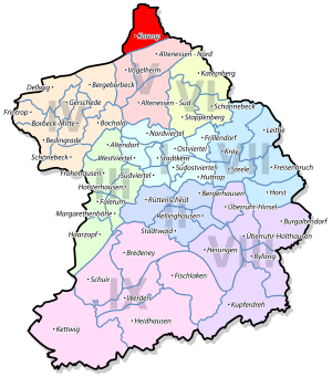
Karnap is the northernmost district of Essen and the only one north of the Emscher .
location
Karnap measures 2.1 kilometers in north-south direction, 1.6 kilometers east-west. In the south of the district, the Rhine-Herne Canal, which runs parallel to the Emscher, forms the border to the neighboring districts of Altenessen and Vogelheim . In the west, Karnap borders on Bottrop , in the north on Gladbeck and in the east on Gelsenkirchen . The lowest point in Essen is 26.5 meters above sea level in the district.
history
Carnap, first mentioned in a document in 1332, was written with "C" until 1910. It is characterized by its special geographical location. The former farmers of Karnap belonged to the municipality of Altenessen, formed in 1808 , and thus from 1813 to the mayor's office of Altenessen. When they were incorporated into the city of Essen in 1915, Karnap left the company and achieved communal independence for a short time. Mayor during this time was Carl Hold . In August 1929, Karnap was also incorporated into Essen.
For over 100 years, Karnap was strongly influenced by mining with its numerous ancillary businesses. Until the 1950s it was a district that had more jobs than residents. The decline of mining dragged on through the 1960s and reached its climax at the end of December 1972 with the closure of the Mathias Stinnes colliery . Over 6,000 jobs had been lost in just under a decade. The rope sheave of the Mathias Stinnes 3/4 colliery in Brauck, installed at the Arenbergstraße stop in 1982, is a reminder of the mining tradition.
population
On March 31, 2020, 8,167 people lived in Karnap.
Structural data of the population in Karnap (as of March 31, 2020):
- Proportion of population under 18-year-olds: 19.3% (Essen average: 16.2%)
- Population of at least 65-year-olds: 17.8% (Essen average: 21.5%)
- Proportion of foreigners: 20.7% (Essen average: 16.9%)
Infrastructure
In the district are the Maria Kunigunda primary school as well as the soccer club Karnap 07/27, the tennis club Essen-Karnap 1928, the gymnastics club Karnap 04, the civic association Karnap and the Carnap history circle.
Essen-Karnap is on the Duisburg-Ruhrort-Dortmund railway line , which is not used by people . In public transport , Karnap is accessible with the U11 tram line, bus lines 189, 263 and the NE1 night express. The main stop in Essen-Karnaps is Boyer Strasse .
economy
Today, the largest industrial plant in Karnap is the Essen-Karnap waste incineration plant , the joint waste incineration plant of the cities of Bottrop, Essen, Gelsenkirchen, Gladbeck and Mülheim an der Ruhr . It was built in the early 1960s after the former hard coal power station had been converted. There are also glass factories in the district.
coat of arms
Blazon : In blue, a silver (white) horse ram lying obliquely to the left with a golden (yellow) cord. In the 14th century the von Carnap family gave themselves a similar coat of arms; in the penultimate form with a vertical pram and brown cord, but the color brown does not appear in heraldry and has been replaced here by gold.
literature
- Walter Buschmann : Karnap: Street design in the Mathias Stinnes settlement. In: Preservation of monuments in the Rhineland. No. 2, 1989, ISSN 0177-2619 , pp. 42-43.
- Detlef Hopp : The rediscovery of a statue of "St. Nepomuk" at St. Marien in Karnap. In: Detlef Hopp (Hrsg.): Stadtarchäologie in Essen . Pomp Verlag, Bottrop 1999, ISBN 3-89355-203-0 , pp. 84-86.
See also
Web links
Individual evidence
- ↑ a b c Karnap city history ; accessed on May 6, 2014
- ↑ Population figures of the districts
- ↑ Proportion of the population under 18 years of age
- ↑ Proportion of the population aged 65 and over
- ↑ Proportion of foreigners in the city districts
- ↑ Karnap Civic Association. Retrieved May 6, 2014 .


