
Heisingen
|
Heisingen |
|

|
|
| Basic data | |
|---|---|
| surface | 6.83 km² |
| Residents | 12,749 (March 31, 2020) |
| Coordinates | 51 ° 24 '14 " N , 7 ° 3' 54" E |
| height | 89 m |
| Incorporation | Aug 1, 1929 |
| Spatial assignment | |
| Post Code | 45259 |
| District number | 31 |
| district | District VIII Essen-Ruhr Peninsula |
| image | |
 Heisingen, aerial view, (in the background Kupferdreh ) |
|
| Source: City of Essen statistics | |
Heisingen is a southern district of Essen , which lies north of the Ruhr on a peninsula.
location
Heisingen is located to the north in a loop of the Ruhr, which merges into the Baldeneysee to the west. The neighboring districts, separated by the Ruhr, are Überruhr and Byfang in the east, and Kupferdreh and Fischlaken in the south. Bredeney follow to the west , then Rellinghausen and Stadtwald to the north, where the Heisinger Bach forms the border. Here Heisingen lies in the nature reserve Schellenberger Wald. The district on the peninsula in the south slopes down from the high-altitude town center of Heisingen towards the Ruhr.
character
Today Heisingen, which is characterized by medium - sized companies , consists mainly of mostly loose residential developments with a town center and some surrounding nature reserves.
In the Schellenberg Forest, near the Schellenberg hunting lodge , there is the Korte-Klippe viewpoint , which offers a view of the Ruhr valley and Lake Baldeney. There is an old watermill and the Rote Mühle lock in the Heisinger Ruhr meadows . Heisingen's old town hall was built in the town center in 1910/1911. The Wottelfest traditionally takes place here on the last weekend in August. The word Wottel comes from the root, meaning the carrot. Heisingen also has a small mining and local museum in the Paulushof.
Located in a wooded area in the exchange path, on a hill to Wuppertal street, there is a flier monument in memory has come at seven to death crew of a crashed in 1918 about at this point German military aircraft of the type Zeppelin (Staaken) R.VI built has been.
The Heisinger Ruhraue nature reserve has been an approximately 150 hectare nature reserve since 2004; At the tip of the Heisinger Peninsula, the Heisinger Bogen bird sanctuary offers numerous rare bird species a retreat.
population
On March 31, 2020 there were 12,749 residents in Heisingen.
Structural data of the population in Heisingen (as of March 31, 2020):
- Proportion of population under 18-year-olds: 14.7% (Essen average: 16.2%)
- Population share of at least 65-year-olds: 29.9% (Essen average: 21.5%)
- Proportion of foreigners: 3.9% (Essen average: 16.9%)
Attractions
- Old Town Hall
- Baldeneysee
- Mining and local history museum in the Paulushof
- Geological Wall Kampmann Bridge
- House Heisingen
- Schellenberg hunting lodge
- Heisingen youth hall
- Kampmann Bridge
- St. George Church
- Korte cliff
- Engine house of the Hundsnocken colliery
- Pauluskirche
- Red mill
- Carl Funke settlement
- Carl Funke colliery

old Kampmann Bridge
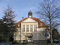
Old Heisingen town hall

Carl Funke colliery on the Ruhr

Pauluskirche


Infrastructure
The district has a municipal community primary school with the Carl-Funke-Schule and a Catholic primary school with the Georgschule. This includes the Catholic parish church of St. Georg , which was built in the neo-Gothic style between 1879 and 1881. The interior of this church was created by the Westphalian artist Heinrich Gerhard Bücker . Another church is the Evangelical Paulus Church, built in 1907. The mining and local history museum is housed in the Paulushof nursing home of the Protestant parish of Essen-Heisingen. The initiator for the museum was the pastor Werner Hamacher at the time.
Notable sports clubs include Heisinger SV, created in 1996 from a merger between the football department of DJK Heisingen and FC Heisingen, as well as DJK Heisingen and SG Heisingen. The DJK and the SG provide popular sports departments, with the SG Heisingen having a gym wheel department. The best-known athlete from Heisingen is the former national soccer goalkeeper Jens Lehmann , who took his first steps with the HSV predecessor club DJK Heisingen.
Heisingen is connected to local public transport by bus routes 145, 146, 153, 155, NE 7 and T 72 of the Ruhrbahn . The federal road 227 , which merges into the federal motorway 44 within Heisingen , leads past the buildings in Heisingen .
The route of the Ruhr Valley Railway , where Heisingen had a train station at kilometer 31.6, is barely recognizable. Your Ruhr bridge is important for cyclists to Kupferdreh.
history
It is believed that the village of Heisingen emerged in the course of large settlement actions by the Franconian Ripuarians and the Saxon Brukterer around the 7th or 8th century. The Ripuarians came from the southwest, the Brukterer, who lost their independence in 695 and belonged to the Saxons, came from the area around Steele , which was their dominion. Both centuries were marked by Saxon incursions and counter-campaigns by the Franks.
middle Ages
Heisingen was first mentioned as a gift on February 24, 796. Heinrich von der Ruhr left his clearing in the Heissiwald to the later Saint Liudger (* approx. 742 - † 809).
In the Middle Ages, Heisingen's history is closely linked to two spiritual communities and their economic and political charisma: that of the Werden monastery , founded around 800 by the Frisian missionary Liudger , acquired property in Heisingen as early as the 9th century, as the Werdener Basilica, Heisingen's affiliation with the abbey is mentioned. From then on, these goods were part of the rapidly developing Werden manorial rule in this area with the Fronhöfe Barkhoven and Viehausen (near Werden) and the fiefdom house Heisingen . At the beginning of the 13th century they were finally integrated into the then emerging sovereignty of the Werden abbots. The Essen women's community, founded around the middle of the 9th century, has been in existence since the 9th / 10th. Century owned by Fronhof Eickenscheidt (near Steele). A number of Heisinger farms also depended on this Fronhof, without there being more than an economic dependence on the Essen women's monastery in the late Middle Ages .
It also corresponded to the fact that the Essen tithe district in the south only extended as far as the area of Rellinghausen , while this, encompassing the Heisingen area, was followed by the tithe entitlement and the parish of the Werden monastery. The parish church for the Heisingers remained the Werden abbey church or St. Lucius church or Neukirchen for almost the entire Middle Ages . Heisingen only got a chapel in 1493, which was soon dedicated to St. George.
There is hardly any reason to associate the place mentioned in 834 with the early medieval forest area north of the lower Ruhr, the Heissi Forest, as if the evidence for the Heissi Forest was an early name for Heisingen. It is clear that both topographical names have the same origin, namely the Germanic (destination) word + hais , hes for forest, bush, wood , related to the Latin caesus . But the name Heissi in the documents from 796 and 800 is used exclusively for the forest that is called Heissi and therefore at least for a forest area from Heisingen to Mülheim-Heißen. The place name Heisingen is first documented in the document from 834 as a place called Heisingen , whereby the suffix -ing (en) in the settlement name is used to denote associations of people (including settlements). The clearing in the Heissi forest mentioned in 796 and 800 should therefore have little to do with the Heisingen settlement. It still remains to determine the age of the -ingen settlement names in the Rhineland. However, the relatively few place names on -ingen (on the right bank of the Rhine) are not meaningful enough to derive a temporal layer for the development of the settlements in question. Suffice it to say here that this is an older name layer.
Heisinger Höfe
In 1370, 23 farms were named in the register of Werden Abbey, all of which belonged to the two main farms Barkhof and Viehhausen of Werden Abbey, and thus belonged to the church property. Therefore, at the time of secularization in 1802, the farms fell to the Prussian tax authorities, who gave them for lease and later for sale. Seven of the 23 farms were still used for agriculture in 1930. In the 1950s, more and more areas were sold by their owners as building land or they were self-built, so that in 1955 the last two farmers in the Oberdorf stopped farming.
In the core of Heisingen was the Rohmannshof (Op dem Rode), which was probably named after the starting point of the clearing in the Heissiwald and was mentioned as early as 1150. The Siepmannshof was also mentioned as a neighboring farm , which was in Siepen (later Kuhsiepen) and was divided into Grotesiepen (Siepmannshof) and Kleinesiepen in 1370. The term Kuhsiepen suggests a ravine to the cattle drive in a water-bearing valley to the pastures on the Ruhr. The farm Small Siepen was also called Kramp Siepen after Aufsitzer staples.
In the north-west of Heisingen was the Grotkampshof, already mentioned in 1250, the later Vogelsanghof and the Kleinkampshof. Farmer Werntgen lived on the Kleinkampshof until 1973 after giving up farming in 1955.
The cattle were driven north into the forest on Viehgate, today's Malmedystraße. The Gatherhof and the Wittenhof were on this path. The taxes from the Wittenhof were paid to Burkhard von Kückelsheim , the gentleman at Schellenberg Castle .
In the north-easternmost part of the lower village was the Hickingshof, known since around 1400, to which the Stenneshof, also Steinhus, joined a little south. In 1524 Lutter Staël von Holstein was enfeoffed with the Stenneshof from the Kofeld farm, today's Heisingen house . From the Stenneshof's own quarry, Ruhr sandstones also come from the neo-Gothic St. Georg Church, which was built in 1879. The Kofeld farm, today's Heisingen house, was fortified like a castle in the 11th and 12th centuries to secure the Franconian part of the village, when the border between the Franconian Empire and Old Saxony temporarily ran through Heisingen.
The Stemmerhof, already mentioned in 1250, which was between Rohmanns- and Stenneshof, had to maintain the stone trap in the Ruhr, because it had to provide the provost of Werden with fish for his table.
The way from Heisingen to the Ruhr and on to Werden ran through the middle of the Geilenkotten mentioned in 1400, the southernmost of all courtyards. In 1938 the Stennes family stopped farming after they bought the farm in 1903 and lived there a little later.
Industrialization until today
Towards the end of the 16th century, the discovery of hard coal gave the village, which had been dominated by agriculture, a new image. More and more holes and later tunnels were dug. Several small mines grew together to form the large Carl Funke colliery , which mined its largest amount of coal of 617,000 tons with 2,450 employees in 1954. The colliery was closed in 1973 and its headframe is now a listed building.
On February 1, 1872, the Ruhr Valley Railway was opened by the Bergisch-Märkische Eisenbahn-Gesellschaft , connecting Heisingen to the lower end of Bahnhofstrasse, which got its name on March 19, 1877, initially with a passenger stop. On April 7, 1894, the extension to the station with a freight station for wagonload traffic and general cargo was approved, which was then achieved by expanding the track system. The main task of the Ruhr Valley Railway was to transport the coal from the mines in the Ruhr Valley to the Ruhrort port . Heisingen, with the town center and the market square, was not only directly connected to the new railway line via Bahnhofstrasse, but was also well connected to the Ruhr ferry to the opposite communities of Hamm and Fischlaken . In particular, workers from the Richradt colliery there , the Dreckbank mine at Hesperbach and the Pörtingsiepen colliery used this route. On the upper part of Bahnhofstrasse, in the upper village, shops and handicraft businesses have settled. These included two Jewish families who, however, had to give up their businesses at the time of National Socialism .
In 1895 the first Kampmann Bridge , an important connection with Kupferdreh, was completed as a pontoon bridge . It was replaced by the current bridge between 1950 and 1951.
Mayor was Emil Hagmann from April 1, 1910 to October 18, 1919 and Hugo ten Hövel from 1920 to the incorporation in Essen on August 1, 1929 .
coat of arms

Blazon : “In silver (white) a three-pinned red wall with an open gate, above the gate a silver (white) ball; above is an upright, three-leaved green beech branch, surrounded by six red balls. "
The coat of arms was designed by Kurt Schweder and never had an official character. At the end of the 1980s, the heraldist created coats of arms for all of Essen's districts. They have meanwhile been well received by the Essen population.
The coat of arms is a so-called speaking coat of arms ; "Heisingen" or "Hesingi" means a "clearing in the beech forest", the "Heissi forest" that was mentioned in Roman times. The balls come from the coat of arms of the former knight residence of the Lords of Stael.
Personalities
- Friedrich Ludger Kleinheidt (1830–1894), theologian, vicar general of the Archbishop of Cologne
- Emil Hagmann (1872–1919), politician, First Mayor of Heisingen from 1910–1919
- Clemens Freitag (1883–1969), painter
- Hugo ten Hövel (1890–1953), politician, second and last Mayor of Heisingen from 1920–1929
- Karl Schlüter (1907–1993), architect and construction clerk, honorary citizen of the RWTH
- Heinrich Schürmann (1922–2010), politician, member of the state parliament and council member
- Kurt Burger (1927–2008), mining engineer and geologist
- Martin Lindow (1965-), actor
- Jens Lehmann (1969–), soccer goalkeeper, a. a. Vice World Champion 2002 and Vice European Champion 2008
literature
- Mining and local history museum in Paulushof, Heisingen citizenry eV (Ed.): Heisinger Denkmalpfade. A hiking guide to the historical sites in Heisingen , Essen 2004
- Mining and local history museum in the Paulushof (ed.): Time leaps Essen-Heisingen , Erfurt 2013, ISBN 978-3-95400-251-1
- Bettecken, Winfried: Abbey and City of Essen. Coenobium Astnideä and settlement development up to 1244 (= sources and studies 2), Münster 1988
- Blok, Dirk Peter: De oudste particuliere Oorkonden van het klooster Werden. A diplomatic study with some uitweidingen over het onstaan van dit soort oorkonden in het algemeen (= Van Gorcum's Historische Bibliotheek 61), Assen 1960
- Bötefür, Markus , Buchholz, Gereon, Buhlmann, Michael: Picture Chronicle 1200 Years of Becoming , Essen 1999
- Buchholz, Gereon, Vollmer, Manfred (Eds.): Heisingen , Leipzig 2002, ISBN 978-3-934572-35-5
- Cram, Ilse, Oldenburg, Margret: Heisingen in 1803 - at the time of secularization (= From Heisingen's past 3), Essen 2019, ISSN 2365-2306
- Dattenberg, Klaus: When Heisingen still had a train station. Memories of the railway from its beginnings in 1872 to the present day (= From Heisingen's past 2), Essen 2017, ISSN 2365-2306
- Detering, Horst: From evening light to dwarf mother. 400 years of mining in Heisingen , Essen 1998, ISBN 978-3-88474-739-1
- Hopp, Detlef (Ed.): Schlaglichter. Insights into the archeology of Heisingen (= From Heisingen's past 1), Essen 2014, ISSN 2365-2306
- Kötzschke, Rudolf : Studies on the administrative history of the manorial estate in the Ruhr , Leipzig 1901
- Museum circle of the mining and local history museum in the Paulushof (ed.): Essen-Heisingen (= The archive pictures series), Erfurt 2004, ISBN 978-3-89702-775-6
- Schäfer, Karl Heinrich , Arens, Franz (eds.): Documents and files of the Essen Minster Archives (= Essen contributions 28), Essen 1906
- Schäfer, Karl Heinrich: History of the Oberhof Eickenscheidt in the area of the princes of the imperial abbey of Essen. With special consideration of the legal and economic circumstances , in: Essener contributions 32 (1910), pp. 1–123
- Stüwer, Wilhelm (edit.): The Reichsabtei Werden an der Ruhr (= Germania Sacra , New Series 12, The Archdiocese of Cologne 3), Berlin-New York 1980
- Tosch, Hans-Gerd (Ed.): Heisingen then and now , Essen 1977
- Wirtz, Wilhelm: The brands in the donors Essen and Rellinghausen. A constitutional and economic historical study , in: Essener contributions 43 (1926), pp. 3–144
See also
Web links
- Mining and local history museum in the Paulushof
- Citizenship Heisingen eV
- Literature about Heisingen in the catalog of the German National Library
- Literature about Heisingen in the North Rhine-Westphalian Bibliography
Individual evidence
- ↑ Population figures of the districts
- ↑ Proportion of the population under 18 years of age
- ↑ Proportion of the population aged 65 and over
- ↑ Proportion of foreigners in the city districts
- ^ Ruhrbahn
- ↑ "Dorfhöfe" board on the Heisingen Monument Trail. Retrieved June 21, 2018 .
- ↑ "Bahnhofstrasse" board of the Heisinger Memorial Trail. Retrieved June 21, 2018 .
- ↑ See also Johann Rainer Busch: "Kurt Schweders Wappen der Essener Stadtteile" Essen 2009, p. 95

District I: city center | East Quarter | North Quarter | West Quarter | Südviertel | Southeast Quarter | Huttrop | Frillendorf | District II: Bergerhausen | Rellinghausen | Rüttenscheid | City forest | District III: Altendorf | Frohnhausen | Fulerum | Pigtail | Holsterhausen | Margarethenhöhe | District IV: Condition levels | Bergeborbeck | Bochold | Borbeck-Mitte | Dellwig | Frintrop | Gerschede | Schönebeck | District V: Altenessen | Karnap | Bird home | District VI: Katernberg | Schonnebeck | Stoppenberg | District VII: Freisenbruch | Horst | Kray | Leithe | Steele | District VIII: Burgaltendorf | Byfang | Heisingen | Copper turning | Überruhr | District IX: Bredeney | Fish sheet | Heidhausen | Kettwig | Schuir | Become