Lichtenvoorde
 flag |
 coat of arms |
| province |
|
| local community |
|
|
Area - land - water |
11.49 km 2 11.49 km 2 0 km 2 |
| Residents | 13,015 (Jan. 1, 2017) |
| Coordinates | 51 ° 59 ′ N , 6 ° 34 ′ E |
| Important traffic route |
|
| prefix | 0544 |
| Postcodes | 2741, 2914, 5464, 7021, 7101, 7121-7122, 7131 |
| Website | Homepage of Lichtenvoorde |
| Lichtenvoorde | |
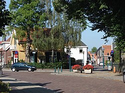
Lichtenvoorde is a village in the Dutch municipality of Oost Gelre in the province of Gelderland . Until January 1, 2005 Lichtenvoorde was an independent municipality. The Zwarte Cross Festival has been taking place in Lichtenvoorde since 2006 , with 152,000 visitors the largest motocross event in Western Europe and one of the largest music festivals in the Netherlands.
From September 18, 1971 to December 31, 1981 there was a community partnership between the community of Lichtenvoorde and the German community of Büttgen , where a street is still named after the community of Lichtenvoorde.
politics
Distribution of seats in the municipal council
Until the municipality was dissolved, the following distribution of seats had been made since 1990:
| Political party | Seats | |||
|---|---|---|---|---|
| 1990 | 1994 | 1998 | 2002 | |
| CDA | 10 | 8th | 8th | 7th |
| Community concerns | 4th | 5 | 4th | 5 |
| VVD | 1 | 2 | 2 | 3 |
| PvdA | 2 | 2 | 3 | 2 |
| D66 | - | - | - | 0 |
| total | 17th | 17th | 17th | 17th |
Personalities
- Johannes Dieker (1880–1968), German local politician
- Marco Blaauw (* 1965), classical trumpeter
- Mirjam Kloppenburg (* 1966), table tennis player
- Tom Holkenborg alias Junkie XL (* 1967), DJ and music producer
- Sander Boschker (* 1970), soccer goalkeeper
- Dave Bus (* 1978), soccer player
- Hidde Jurjus (* 1994), soccer goalkeeper
Web links
Commons : Lichtenvoorde - collection of images, videos and audio files
Individual evidence
- ↑ Kerncijfers wijken en buurten 2017 Centraal Bureau voor de Statistiek , accessed on 19 July 2018 (Dutch)
- ^ History of Lichtenvoorder Strasse in Büttgen
- ↑ Allocation of seats in the municipal council: 1990–2002 , accessed on July 19, 2018 (Dutch)

