Gelderland Province
|
Gelderland Province of the Netherlands |
|
| coat of arms | flag |

|

|
| location | |
|---|---|
| Basic data | |
| Capital | Arnhem |
| Biggest town | Nijmegen |
| ISO 3166-2 code | NL-GE |
| Website | www.gelderland.nl |
| anthem | Ons Gelderland |
| politics | |
| Royal Commissioner | John Berends ( CDA ) |
| Ruling parties | VVD , CDA , GroenLinks , PvdA , ChristenUnie and SGP |
| population | |
| Residents | 2,072,328 ( 4th of 12 ) |
| Country share | 12% of the Dutch |
| Population density | 417 inhabitants per km² ( 6th of 12 ) |
| Religion (2015, CBS ) | 21% - Roman Catholic 12% - Dutch Reformed 7% - Protestant 4% - Reformed 4% - Islam 5% - other 47% - none |
| geography | |
| surface | 5,136.31 km² |
| - country | 4,963.71 km² (2nd of 12) |
| - Water | 172.60 km² |
| height | −1 to 110 m above sea level NAP |
| Coordinates | 52 ° 4 ′ N , 5 ° 55 ′ E |
| Administrative division | |
| Communities | 51 |
|
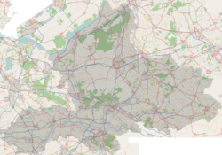
Topography of Gelderland |
|
Gelderland is a province in the eastern center of the Netherlands with the capital Arnhem ( Dutch Arnhem ).
Other large cities are Nijmegen , Apeldoorn and Ede , smaller cities Zutphen , Harderwijk , Tiel and Doetinchem . The name of the province is derived from the historical Duchy of Geldern . The eponymous city of Geldern itself is located in what is now North Rhine-Westphalia , outside of what is now the Netherlands.
geography
The Gelderland can be roughly divided into three parts of the landscape:
- in the north the Veluwe with the largest forest area in the Netherlands - the name is usually interpreted as a pale (barren) floodplain, because agriculture brought in little income here.
- in the southeast of the Achterhoek (as seen from Holland: "Hinteres Eck"), a predominantly agricultural and recently also tourist region.
- in the south the Betuwe , known for its fruit and vegetable cultivation. The name, interpreted as "Bataver-Aue", possibly comes from the Batavern who settled here in the 1st century.
Other areas in Gelderland are the Rijk van Nijmegen , the Liemers and the Geldersche Vallei (= "plain"), a relatively low-lying area around Barneveld , which is known for its chicken farming .
The Gelderland is traversed in the southern provincial area in an east-west direction by the northern branch of the Rhine, the Nederrijn and in the lower reaches of the Lek and the southern branch of the Rhine, the Waal . The Meuse , which forms the border with the province of Noord-Brabant , flows parallel to the Waal . South of Arnhem, the IJssel branches off from the Nederrijn , flows through the province in a south-north direction, to flow into the IJsselmeer at Kampen .
The dialects of the Gelderland are divided into eastern and northern Gelderland as well as southern Gelderland. The former belong to Lower Saxony (in the broader sense) or Low German (in the narrower sense) . The southern dialects, on the other hand - like standard Dutch - developed from Lower Franconian . Both Lower Saxon and Lower Franconian belong to Low German (in a broader sense), whose dialects are also spoken in Northern Germany.
history
Guelders was a region in the late 11th century and later a duchy of the Holy Roman Empire . This also included parts of today 's Limburg province of the German district of Kleve , together with the city of Geldern , which was also the seat of the duke. Erkelenz and Viersen were Geldrian exclaves . The current province covers about three quarters of this duchy of Geldern .
In 1543 the Gelderland finally became one of the seventeen provinces of the Habsburg Netherlands through the Treaty of Venlo at the end of the War of the Geldr Succession . After the Dutch Revolution in 1568, Gelderland belonged to the Republic of the Seven United Provinces . Within this republic, the Duchy of Gelderland had a special position, because the other provinces were only counties or glories. Therefore it was officially ranked even before the richest and most populous province, the county of Holland .
To liberate the region shortly before the end of World War II:
politics
The provincial administration is based in Arnhem . There is the Huis der Provincie in a building from 1954; the previous building was destroyed in the war. The king's commissioner has been John Berends from the CDA since February 2019 . He heads a college of right- wing liberals , Christian Democrats , Greens , Social Democrats , Calvinists and radical conservatives .
In the provincial election on March 20, 2019, the parties obtained the following shares of the vote: VVD 13.96%, FvD 13.43%, CDA 11.58%, GroenLinks 10.83%, PvdA 8.33%, D66 7.20%, ChristenUnie 6.78%, PVV 6.06%, SP 5.83%, SGP 5.25%, PvdD 4.46%, 50PLUS 3.81%, other 2.5%.
The next provincial election will take place on March 22, 2023.
|
(in %)
% 20th 10
0
13.96
13.43
11.58
10.83
8.33
7.20
6.78
6.06
5.83
16.02
Gains and losses
compared to 2015
% p 14th 12 10 8th 6th 4th 2
0
-2 -4 -6 -1.83
+13.43
-3.42
+5.12
-0.71
-5.42
+0.66
-3.66
-5.17
+1.03
|
Communities
On January 1, 2005 there was an administrative reform in the province of Gelderland, in which the number of municipalities fell from 71 to 56. With Berkelland (from the dissolved communities Borculo, Eibergen, Neede and Ruurlo), Bronckhorst (Hengelo, Hummelo / Keppel, Steenderen, Vorden, Zelhem), Montferland (Bergh and Didam) and Oude IJsselstreek (Gendringen and Wisch), four new communities were created . Angerlo (to Zevenaar ), Dinxperlo (to Aalten ), Gorssel (to Lochem ), Lichtenvoorde (to Groenlo , renamed after a referendum to Groenlo-Lichtenvoorde , now Oost Gelre ), Warnsveld (to Zutphen ) and Wehl (to Doetinchem ) . On January 1, 2015, Groesbeek , Millingen aan de Rijn and Ubbergen merged to become Groesbeek, which was renamed Berg en Dal a year later. On January 1, 2018, Rijnwaarden was incorporated into Zevenaar. At the beginning of the year, the municipalities of Geldermalsen , Lingewaal and Neerijnen were merged to form the new West Betuwe municipality . As of January 1, 2019, the number of parishes is therefore 51.
|
|
|
(Residents on January 31, 2019)
economy
In 2011, the regional gross domestic product per inhabitant, expressed in purchasing power standards , was 108.7% of the EU-28 average . In 2017 the unemployment rate was 4.5%.
Individual evidence
- ↑ Religieuze betrokkenheid; kerkelijke gezindte; regio. CBS , December 22, 2016, accessed November 17, 2018 (Dutch).
- ↑ Sjors Moolenaar: Ze zijn er uit: coalitie Gelderland presenteert vanavond accord. In: de Gelderlander . De Persgroep Nederland , May 27, 2019, accessed on July 12, 2019 (Dutch).
- ↑ Provinciale Staten 20 March 2019. In: Verkiezingsuitslagen.nl. Kiesraad , accessed May 1, 2019 (Dutch).
- ↑ Provinciale Staten 18 March 2015. In: Verkiezingsuitslagen.nl. Kiesraad , accessed May 1, 2019 (Dutch).
- ↑ Bevolkingsontwikkeling; regio per maand . In: StatLine . Centraal Bureau voor de Statistiek (Dutch)
- ↑ Eurostat yearbook of the regions 2014 : ( Chapter 5: Economy ; PDF, 18 pages, approx. 2.0 MB) and ( Eurostat source data for Chapter 5: Economy ; XLS format, approx. 536 kB), ISBN 978-92 -79-11695-7 , ISSN 1830-9690 (English)
- ↑ Unemployment rate, by NUTS 2 regions. Retrieved November 5, 2018 .


