
Maasdriel
 flag |
 coat of arms |
| province |
|
| mayor | Henny van Kooten ( SGP ) |
| Seat of the municipality | Kerkdriel |
|
Area - land - water |
75.46 km 2 66.13 km 2 9.33 km 2 |
| CBS code | 0263 |
| Residents | 24,690 (Jan 31, 2019) |
| Population density | 327 inhabitants / km 2 |
| Coordinates | 51 ° 46 ′ N , 5 ° 20 ′ E |
| Important traffic route |
|
| prefix | 0418, 0487, 073 |
| Postcodes | 5321, 5324-5325, 5327-5328, 5331, 5333-5335, 5855, 6624 |
| Website | Homepage of Maasdriel |
 |
|
Maasdriel ( ) is a municipality in the Dutch province of Gelderland . It has a total area of 75.46 km² and, according to the CBS, had 24,690 inhabitants on January 31, 2019 .
places
Between the brackets the possible population of the villages at the beginning of 2017.
- Alem (645), in the northeast of the municipality; Ferry across the Maas to Maren-Kessel (towards Oss )
- Ammerzoden (3005), in the west of the municipality
- Hedel (4525)
- Hoenzadriel (185)
- Heerewaarden (1180)
- Hurwenen (675)
- Kerkdriel (7385), seat of the municipal administration, in the eastern half of the municipality
- Rossum (2755)
- Velddriel (1305)
- Well (790);
as well as some small “Gehuchte” ( farmsteads ), u. a. Wellseind, St. Andries, WordAGEN, etc. a.
Location and economy
The community forms the southeast half of the Bommelerwaard landscape . It is bounded in the north by the Waal arm of the Rhine and in the south by the Maas . Across the Maas, across from Hedel, lies the capital of the province of Noord-Brabant , 's-Hertogenbosch ; many of the residents of Maasdriel municipality are commuters who work there. In the north, Maasdriel is bounded by Zaltbommel .
Rijksweg 2 ( Utrecht -'s-Hertogenbosch) runs right through the municipality . Exit 19 of this trunk road is between Hedel and Velddriel. Rail travelers are dependent on the train stations in 's-Hertogenbosch and Zaltbommel; There are bus connections from there, but there are not regular buses to all villages.
Economically important are agriculture and horticulture, u. a. the cultivation of strawberries and mushrooms . Notably Ammerzoden and Hedel also some small businesses and trade, u. a. in Ammerzoden a wholesaler of potatoes.
history
The population of this parish is predominantly Catholic; they are strongly oriented towards North Brabant, which sometimes led to problems with the Protestant provincial administration of Gelderland from the 16th to the 19th century.
Most of the places in the parish have been around for a long time. A Roman fort called Grinnes is said to have stood near Rossum ; it is indicated on the Peutinger map as a Grinnibus . However, some scientists deny that this fort stood here. The first documentary evidence of the villages (years according to the Dutch Wikipedia):
- Alem: 1107
- Ammerzoden: Ammersoyen Castle, 11th century
- Hedel and Kerkdriel: 815 or 816. From 1869 to 1950, Hedel had a small train station on the Zaltbommel-m 's-Hertogenbosch railway line.
- Heerewaarden: around 1000
- Rossum: 893
- Velddriel: an abbey was founded here in 1265 ( renewed in 1905 by the tutors van Liefde )
- Well: 983 (certificate from Essen-Werden Abbey )
- Wordrags: 13th century.
During the Eighty Years' War in 1599, not far from Heerewaarden, the important Fort Sint-Andries with the nearby Sint Andries Canal was built. The fortification, which is strategically important because of its location (from the fort, you can attack shipping on the Waal and the Meuse with old-fashioned cannons or machine guns) was renewed in 1812. In April 1945 there was still fighting for this fort between German and Allied troops. The remains of the facility can be viewed freely. In the 19th century this area was quite poor. Heerewaarde had a fishing port, but elsewhere you lived a meager existence as a smallholder or thatched basket weaver. At that time, many men especially moved away from Velddriel, among other things to work in the coal mines of the Ruhr area . The village and Ammerzoden Castle suffered considerable damage in the Second World War. The ferry at Alem was a popular spot for resistance fighters in this era, where they could cross the Meuse unseen at night.
politics
Distribution of seats in the municipal council
The municipal council has been formed as follows since 2006:
| Political party | Seats | |||
|---|---|---|---|---|
| 2006 | 2010 | 2014 | 2018 | |
| Seed Sterk Maasdriel | 2 | 4th | 6th | 7th |
| CDA | 7th | 7th | 9 | 6th |
| VVD | 5 | 5 | 2 | 3 |
| PvdA | 3 | 1 | 1 | 2 |
| GroenLinks | 2 | 2 | 1 | |
| D66 | - | - | - | 1 |
| SGP | 0 | 0 | 0 | 0 |
| Community affairs Maasdriel | 0 | - | - | - |
| total | 19th | 19th | 19th | 19th |
mayor
Henny van Kooten ( SGP ) has been acting mayor of the municipality since November 21, 2014 . His colleagues include the alderman Jan Hein de Vreede (Samen Sterk Maasdriel), Peter de Vries ( CDA ), Anita Sørensen (CDA), Erik van Hoften (Samen Sterk Maasdriel) and the municipal secretary Ad de Jong.
Sights / events
- Ammersoyen Castle in Ammerzoden: the castle, built in 1350 and rebuilt in the 17th century, is a conference and party center, but can be visited with a guide. It is one of the best preserved medieval moated castles in the Netherlands.
- Every year on the 1st Monday in November there is a horse market with a fair in Hedel .
- The Fort Sint Andries, see above.
- Kil van Hurwenen bird sanctuary, between Hurwenen and Zaltbommel.
- Recreation area with the De Zandmeren marina , east of Kerkdriel on the Meuse.
- In the former Dutch Reformed Church in Alem, the Dutch Roof Tile Museum ( Dakpannenmuseum ) is housed, which shows the history of the roof tile from the 13th century until today. The extensive collection includes not only Dutch pans, but also those from practically all European countries as well as Asia and Africa
- Kerkdriel has a small local museum.
- Heerewaarden has some quaint old houses in the village center.
- Hedel has a castle ruin (the castle built in 1336 was demolished in 1794) and a small marina on the Maas , across from 's-Hertogenbosch.
- The Slot te Well or Huis Malsen castle is near Well. The castle, built in the 15th century and restored in 2002, is used as a residential and office building and cannot therefore be visited inside.
photos

Ammerzoden, lock: kasteel Ammersoyen
Ammerzoden, church: de Heilige Willibrorduskerk

Well, the Reformed Church
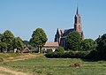
Alem, church: de Sint-Hubertuskerk

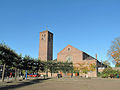
Kerkdriel, tower of the Catholic Church


Important people from Maasdriel
- Johannes Zwijsen , * 1794 in Kerkdriel, † 1877 in Herzogenbusch. Bishop of Den Bosch and from 1853 Archbishop of Utrecht, the first since the Reformation ; he was friends with King Wilhelm II .
Web links
- Website of the municipality (Dutch)
- Website of the Hedel Horse Market (Dutch)
Individual evidence
- ↑ Bevolkingsontwikkeling; regio per maand . In: StatLine . Centraal Bureau voor de Statistiek (Dutch)
- ↑ Result of the local elections: 2014 2018 , accessed on July 15, 2018 (Dutch)
- ↑ Allocation of seats in the municipal council: 2006 2010 2014 2018 , accessed on July 15, 2018 (Dutch)
- ^ College van burgemeester en wethouders Gemeente Maasdriel, accessed on July 15, 2018 (Dutch)
- ↑ Dakpannenmuseum ( Memento of the original from February 21, 2009 in the Internet Archive ) Info: The archive link was automatically inserted and not yet checked. Please check the original and archive link according to the instructions and then remove this notice.
Aalten | Apeldoorn | Arnhem | Barneveld | Berg en Dal | Berkelland | Beuningen | Bronckhorst | Hum | Boers | Culemborg | Doesburg | Doetinchem | Druten | Duiven | Ede | Elburg | Epe | Ermelo | Harderwijk | Hattem | Herd | Hay | Lingewaard | Lochem | Maasdriel | Montferland | Neder-Betuwe | Nijkerk | Nijmegen | Nunspeet | Oldebroek | Oost Gelre | Oude IJsselstreek | Overbetuwe | Putti | Renkum | Rheden | Rozendaal | Scherpenzeel | Tiel | Voorst | Wageningen | West Betuwe | West Maas en Waal | Westervoort | Wijchen | Winterswijk | Zaltbommel | Zevenaar | Zutphen