
Rheden (Netherlands)
 flag |
 coat of arms |
| province |
|
| mayor | Carol van Eert ( PvdA ) |
| Seat of the municipality | De Steeg |
|
Area - land - water |
84.35 km 2 81.77 km 2 2.58 km 2 |
| CBS code | 0275 |
| Residents | 43,638 (Jan 31, 2019) |
| Population density | 517 inhabitants / km 2 |
| Coordinates | 52 ° 0 ′ N , 6 ° 2 ′ E |
| Important traffic route |
|
| prefix | 026, 0313 |
| Postcodes | 6881-6883, 6951-6953, 6955-6957, 6991, 6994 |
| Website | Homepage of Rheden |
 |
|
 |
|
Rheden ( ) is a Dutch municipality in the province of Gelderland and had 43,638 inhabitants on January 31, 2019, according to the CBS . The municipality covers an area of 84.35 km², of which 22 km² are water and 31 km² are forest areas.
places
The municipality of Rheden comprises the following villages (the number of inhabitants between brackets, as of January 1, 2018):
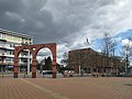
- Velp (18.056), more or less a suburb of Arnhem
- Rheden (7,661)
- Dieren (13,974)
- De Steeg (1,088); the municipal administration is located here
- Ellecom (1,040)
- Laag-Soeren (838), a former health resort
- Chipboard (932)
photos

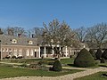
Rheden, country house: de Valkenberg

Velp, river: de IJssel
Velp, street: de Hoofdstraat
Dieren, tower: de Dierense toren
Dieren, monumental building: Schweer at the Beckehof

De Steeg, country house: Huize Rhederpark
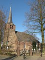
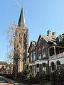
Spankeren, Reformed Church

the Posbank


politics
Distribution of seats in the municipal council
The municipal council has been formed as follows since 2006:
| Political party | Seats | |||
|---|---|---|---|---|
| 2006 | 2010 | 2014 | 2018 | |
| VVD | 4th | 6th | 4th | 5 |
| CDA | 4th | 4th | 4th | 4th |
| SP | 3 | 2 | 5 | 4th |
| PvdA | 7th | 5 | 4th | 4th |
| D66 | 0 | 3 | 5 | 3 |
| GroenLinks | 2 | 3 | 2 | 3 |
| Groep Pieper-Rook a | - | - | 1 | 3 |
| Burger issues | - | - | ||
| ChristenUnie | 1 | 1 | 1 | 1 |
| Community concerns | 6th | 3 a | 1 | - |
| total | 27 | 27 | 27 | 27 |
mayor
Carol van Eert ( PvdA ) has been the acting mayor of the municipality since January 11, 2018 . His colleagues include the alderman Ronald Haverkamp ( VVD ), Marc Budel ( CDA ), Gea Hofstede (PvdA), Dorus Klomberg ( D66 ) and the municipal secretary Hans Kettelerij.
Location and economy
The municipality forms the southeastern edge of the wooded Veluwe landscape between Arnhem in the south and Brummen in the northeast. Velp, Rheden and Dieren have stations on the Arnhem – Leeuwarden railway line ; some express trains only stop in Dieren. The A348 motorway runs along the IJssel between Arnhem and Dieren . Dieren is on the IJssel, but does not have a large port. De Steeg has a marina. There are 3 campsites nearby:
- Dorado Beach
- IJsselstrand
- Zwarte Schaar
The main source of income is tourism . In the east there is also agriculture (dairy farming) along the IJssels. Rheden has a few brick factories, and until recently De Steeg had a large steel mill (closed in 2002). The bicycle factory of the well-known company Gazelle is located in Dieren. In addition, there are still a lot of small businesses, especially in Dieren and between Velp and Arnhem.
history
Rheden was called Rheton in the Middle Ages. That means: place where thatch grows. In the 16th century Rheden with Dieren (Diederen) was a school office, legal area of a mayor . This "schout" was a judge and in these troubled times also the chief policeman. In the 19th century Velp grew strongly, due to its proximity to the administrative center of Arnhem and the settlement of more or less wealthy pensioners, u. a. from The Hague . Middle-class citizens and commuters also settled here later. Dieren became a modest industrial town that had a waterway and a railway connection with Apeldoorn until around 1960 .
Attractions
- At Rheden you can enter the Veluwezoom Nature Park . Hikes and bike tours are possible here. The highest point of the Veluwe, near the simple restaurant Carolinahoeve, which cannot be reached by car, is located here (110 meters above sea level).
- There are many other forests and heathlands in the area.
- There are several castles in the municipality:
- Biljoen , near Velp (15th century);
- Gelderse Toren , near Spankeren (15th century; demolished around 1800 and rebuilt);
- Middachten , at De Steeg (16th century; only Middachten can be visited inside);
- In summer, steam trains run between Apeldoorn and Dieren on the VSM museum railway .
Web links
- Official website of the municipality of Rheden (Dutch)
- Middachten Castle website (Dutch, German, English)
- Website of the Veluwezoom National Park (Dutch, German, English)
Individual evidence
- ↑ Bevolkingsontwikkeling; regio per maand . In: StatLine . Centraal Bureau voor de Statistiek (Dutch)
- ↑ Inwonersaantal en leeftijdsopbouw per dorp / kern 2018 (PDF, 61 kB) Gemeente Rheden, accessed on July 21, 2018 (Dutch)
- ↑ Result of the local elections: 2014 2018 , accessed on July 21, 2018 (Dutch)
- ↑ Allocation of seats in the municipal council: 2006 2010 2014 2018 , accessed on July 21, 2018 (Dutch)
- ^ Nieuwe burgemeester in Rheden. In: Rijksoverheid. December 5, 2017, accessed July 21, 2018 (Dutch).
- ↑ College van burgemeester en wethouders Gemeente Rheden, accessed on July 21, 2018 (Dutch)
Aalten | Apeldoorn | Arnhem | Barneveld | Berg en Dal | Berkelland | Beuningen | Bronckhorst | Hum | Boers | Culemborg | Doesburg | Doetinchem | Druten | Duiven | Ede | Elburg | Epe | Ermelo | Harderwijk | Hattem | Herd | Hay | Lingewaard | Lochem | Maasdriel | Montferland | Neder-Betuwe | Nijkerk | Nijmegen | Nunspeet | Oldebroek | Oost Gelre | Oude IJsselstreek | Overbetuwe | Putti | Renkum | Rheden | Rozendaal | Scherpenzeel | Tiel | Voorst | Wageningen | West Betuwe | West Maas en Waal | Westervoort | Wijchen | Winterswijk | Zaltbommel | Zevenaar | Zutphen