Spankeren (place)
| province |
|
| local community |
|
|
Area - land - water |
5.3 km 2 5.08 km 2 0.22 km 2 |
| Residents | 932 (Jan. 1, 2018) |
| Coordinates | 52 ° 3 ' N , 6 ° 7' E |
| Important traffic route |
|
| prefix | 0313 |
| Postcodes | 6951, 6953, 6956-6957, 6964, 6974, 6994 |
| Location of Spankeren in the municipality of Rheden | |
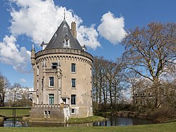
| Tower (de Gelderse Toren) in Spankeren | |
Spankeren is a village in the municipality of Rheden in the Dutch province of Gelderland . The place is at the beginning of the Apeldoorn Canal across from Dieren .
Although Spankeren is a small village, there are two industrial areas along the Apeldoorn Canal where many companies (such as Elitech Benelux BV) are based.
Gelderse Toren Castle, built in the 15th century, is located in Spankeren .
The tuff tower of the Petruskirche in Spankeren dates from the 12th century and is one of the oldest church towers on the Veluwe . The current church dates from the 19th century and has been recognized as a Rijksmonument ( Dutch , literally "Reichsdenkmal") since 1970 .
Web links
Commons : Spankeren - collection of images, videos and audio files
Individual evidence
- ↑ Inwonersaantal en leeftijdsopbouw per dorp / kern 2018 (PDF, 61 kB) Gemeente Rheden, accessed on July 21, 2018 (Dutch)


