Ermelo
 flag |
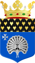
 coat of arms |
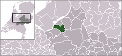
| province |
|
| mayor | André Baars ( CDA ) |
| Seat of the municipality | Ermelo |
|
Area - land - water |
87.33 km 2 85.64 km 2 1.69 km 2 |
| CBS code | 0233 |
| Residents | 26,877 (Jan 31, 2019) |
| Population density | 308 inhabitants / km 2 |
| Coordinates | 52 ° 18 ' N , 5 ° 38' E |
| Important traffic route |
|
| prefix | 0341 |
| Postcodes | 3851-3853 |
| Website | Homepage of Ermelo |
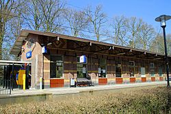
| Ermelo train station | |
Ermelo ( ) ( Lower Saxony Armel ) is a sprawling village and a municipality in the Dutch province of Gelderland in the Veluwe . On January 31, 2019, Ermelo had 26,877 residents.
places
- Ermelo, where the municipal administration is located
- Leuvenum, a small hamlet in the middle of the forest
- Staverden, a group of farms around a castle, near the Apeldoorn - Harderwijk road
- Three (actually three old farms, with a few other apartments) also in the middle of the forest
- Horst, a hamlet on the Veluwemeer
Location and economy
Ermelo is located a few kilometers south of the city of Harderwijk , on the Veluwemeer, a marginal lake of the IJsselmeer . The local trains between Amersfoort and Zwolle stop every half hour at Ermelo station. Tourism and the large psychiatric clinics in the area are of great importance for the economy of Ermelo.
politics
Distribution of seats in the municipal council
The municipal council has been formed as follows since 2006:
| Political party | Seats | |||
|---|---|---|---|---|
| 2006 | 2010 | 2014 | 2018 | |
| CDA | 7th | 5 | 7th | 6th |
| Progressive Ermelo a | 4th | 4th | 4th | 4th |
| ChristenUnie | 3 | 3 | 3 | 4th |
| BurgerBelangen Ermelo b | - | - | 3 | 3 |
| SGP | 1 | 2 | 2 | 2 |
| VVD | 3 | 3 | 2 | 2 |
| Community concern | 2 | 2 | - | - |
| Dorpspartij Ermelo | 1 | 2 | - | - |
| total | 21st | 21st | 21st | 21st |
mayor
André Baars ( CDA ) has been the acting mayor of the municipality since December 16, 2011 . His colleagues include the alderman Hans de Haan ( VVD ), Laurens Klappe (Progressief Ermelo), Leo van der Velden ( SGP ), Wouter Vogelsang (BurgerBelangen Ermelo) and the municipal secretary Aldrik Weststrate.
history
As early as 2300 BC BC, in the Neolithic Age , people lived here. This emerged from archaeological excavations in Ermelo.
- For the Roman past see the separate article Marschlager Ermelo .
Ermelo was first mentioned in a document as Irminlo (large clearing in the forest) in 855. In the early Middle Ages , Saxons or Franks are said to have had a settlement here. It has not been proven whether these people here worshiped the god Irmin . The thesis mentioned in many books, according to which Ermelo comes from the god-name Irmin, has recently been heavily questioned by scientists. Irmin is supposed to be an old word for "big". In the 13th century, an important hunting lodge called Staverden was built southeast of Ermelo. The lords of this castle even received city rights from the Duke of Geldern for the area around the house , as well as the exclusive right to breed white peacocks . The feathers of these birds were used to decorate the hats of the high nobility and were sold at high prices. The castle was destroyed several times; the present whitewashed building dates from 1905.
Ermelo itself was a somewhat poor farming village until around 1830. The situation improved when the Zuiderzeestraatweg , a good road in the Zuiderseedörfer between Amersfoort and Zwolle , was completed. Then in 1862 a small train station was opened on the outskirts of the village. Around 1870, the two large psychiatric institutions Veldwijk and 's Heeren Loo settled here . Around 1950 a large barracks was added, making the military the second largest employer in the village. Until then, Ermelo formed a community with the neighboring Nunspeet . Due to conflicts of interest, including in the economic field, the Ermelo municipality split off in 1972 (see: Nunspeet # history ).
Attractions
- Strand Horst: a bathing beach with a marina and other water sports on the Veluwemeer; the A28 Amersfoort - Zwolle motorway has an exit here;
- the many forests and heather areas of the Veluwe , where many walks and bike rides are possible; There are also opportunities for riders;
- the surroundings of Staverden Castle (the castle itself is privately owned and cannot be visited).
Sons and daughters of the church
- Aart Vierhouten (* 1970), racing cyclist
- Werner Vogels (* 1958), computer scientist
Web links
- Website of the municipality (Dutch)
- Website of the local tourist board (Dutch, English)
- Ermelosche Heide sheepfold and visitor center website (Dutch)
Individual evidence
- ↑ Bevolkingsontwikkeling; regio per maand . In: StatLine . Centraal Bureau voor de Statistiek (Dutch)
- ↑ Result of the local elections: 2014 2018 , accessed on July 12, 2018 (Dutch)
- ↑ Allocation of seats in the municipal council: 2006 2010 2014 2018 , accessed on July 12, 2018 (Dutch)
- ↑ Samenstelling college van B&W Gemeente Ermelo, accessed on July 12, 2018 (Dutch)

