IJssel
|
Gelderland IJssel Geldersche IJssel |
||
|
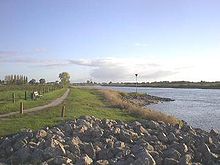
IJssel near Deventer |
||
| Data | ||
| Water code | EN : 928 | |
| location | Gelderland and Overijssel , Netherlands | |
| River system | Rhine | |
| Drain over | IJsselmeer → North Sea | |
| Beginning |
Bifurcation of the Pannerdens Canal near Arnhem 51 ° 57 ′ 4 ″ N , 5 ° 57 ′ 9 ″ E |
|
| Source height | 9 m NAP | |
| muzzle |
Ketelmeer near Kampen / schlussdeich Coordinates: 52 ° 35 ′ 16 ″ N , 5 ° 49 ′ 55 ″ E 52 ° 35 ′ 16 ″ N , 5 ° 49 ′ 55 ″ E |
|
| Mouth height | 0 m NAP | |
| Height difference | 9 m | |
| Bottom slope | 0.07 ‰ | |
| length | 123 km | |
| Catchment area | 4270 km² | |
| Drain |
MQ |
380 m³ / s |
| Right tributaries | Issel , Berkel , Schipbeek | |
|
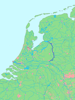
Location of the IJssel |
||

The IJssel ([ ˈɛi̯səl ], German IJssel or Issel written and pronounced Eissel ) is the northernmost branch of the Rhine into the North Sea . It branches off from the Nederrijn at Westervoort near Arnhem and flows into the IJsselmeer , the largest lake in the Netherlands (formerly the Zuiderzee , a bay in the North Sea) at Kampen .
The IJssel / Issel was originally an independent river before the Rhine broke through to the IJssel / Issel and turned it into an estuary of the Rhine. This is why the source of the IJssel / Issel is located near Raesfeld in the southwest of the Münsterland . The section of the river from the source to the confluence of the Issel with the IJssel near Doesburg is called Issel in German and Oude IJssel (“Alte Eissel / Issel”) in Dutch .
Since there are two different rivers with the name IJssel in the Netherlands, the IJssel mentioned here is also called Geldersche IJssel (German “ Gelderland Eissel”) to distinguish it from the Hollandse IJssel (German “ Dutch Eissel”).
Name designation and spelling
In Dutch , IJ is a ligature that is understood as a single letter. The first letter is capitalized for proper names. Since the first letter in Dutch is not just the I, but the IJ, the J is also capitalized in Dutch.
Junction and course
Southeast of Arnhem , almost 13 kilometers below the German section of the Rhine, the Pannerden Canal , which has already branched off from the main stream ( Boven Rijn , Waal ) , forks into the Nederrijn , which flows to the left (west) and is at least 90 meters wide, and the IJssel, which is at least 70 meters wide, which immediately turns sharply to the east.
After 19 kilometers of river near Doesburg, the IJssel takes in the Issel, which comes from the right (east), as the first major tributary , its former upper course, which is known in the Netherlands as the Oude IJssel . All other larger tributaries also flow from the right, like the Berkel at Zutphen and the Schipbeek at Deventer . On the left, the river accompanies the Saale Ice Age moraine hill country of the Veluwe with forest slopes up to 90 meters high. It is partly followed by the border between the provinces of Gelderland and Overijssel . Shortly before Zwolle , the IJssel turns to the northwest and then flows into the Ketelmeer at Kampen , a bay of the largest freshwater lake in the Netherlands, the IJsselmeer . In Zwolle the Zwolle-IJsselkanaal branches off to the right to Zwarte Water . The Vechte , which rises in the Münsterland, also flows into the Ketelmeer, which continues its name after it flows into the Zwarte Water. The actual confluence of the IJsselwasser into the open sea occurs through the tidal barriers of Den Oever ( Stevinsluizen ) and Kornwerderzand ( Lorentzsluizen ).
History of origin
The Issel is only separated from the Rhine lowlands by an island-like ridge. In several places the watershed lies on the oldest line of the Rhine dike. Old river sediments prove that before the construction of the Rhine dyke between Rees , Isselburg and Anholt and also at Zevenaar, the Rhine flood repeatedly overflowed to Issel (Oude IJssel).
According to widespread belief, the uppermost section of the river as far as Doesburg developed from the Fossa Drusiana , which shortened the route of the Roman fleet to the then, Flevum lake (now the IJsselmeer ) and from there to the German Bight . Intensive research on the history of the Rhine delta at the geoscientific faculty of the University of Utrecht casts doubt on this view, since the remains of Roman canals have been found elsewhere in the Netherlands, but not on the IJssel between Westervoort and Doesburg (and also not on the one that is also considered for this purpose drawn Hollandse Vecht ).
The sediment research regarding earlier courses of the IJssel is still in progress. Among other things, the possibility is being considered that the Oude IJssel once flowed into the Rhine. The river bed between Westervoort and Doesburg would then be at least partially of natural origin, albeit initially flowing through in the opposite direction - a not uncommon occurrence in the Rhine-Maas Delta .
Hydraulic development
During the 17th century, the Waal increasingly developed into the dominant estuary with over 90% of the water supply of the Rhine, so that shipping on Nederrijn and IJssel could come to a standstill in summer. In order to counteract this, but primarily for reasons of defense against France, the Pannerden Canal was built between 1701 and 1707, which was accompanied by an initially uncontrolled increase in the outflow in Nederrijn and IJssel. In a treaty between the Kingdom of Prussia (with a Klevian exclave on the Pannerden Canal) and the Dutch Republic of the Seven United Provinces of 1771, it was finally agreed to secure an outflow proportion, according to which the Nederrijn 2/9 and the IJssel 1/9 of the water volume of the Rhine should lead away; this is an average of around 250 m³ / s. One of the seven provinces was named after the IJssel: Until 1528, Overijssel was part of the diocese of Utrecht , from which it was over de IJssel - across the Issel .
With the completion of the final dike in 1932 as part of the Zuiderzeewerke , the IJssel no longer flows directly into the sea; its catchment area became part of a larger inland water system around the IJsselmeer, which reaches the North Sea via the dike. Its main river is the IJssel, which, reinforced by tributaries, at Kampen at the transition to the IJsselmeer (until around 1971) carried an annual average of over 280 m³ of water per second.
With the construction of the Delta Works , the weir at Driel am Nederrijn was completed in 1971, which, depending on the flow of the Rhine, regulates the amount of water in the IJssel so that it carries an average of 100 m³ / s (around 40%) more water than before . If the Rhine flows below 1400 m³ / s, the Nederrijn only has a minimum discharge of 25 m³ / s, otherwise the flow of the Pannerden Canal benefits the IJssel. At higher flow rates up to the mean water flow of the Rhine (2300 m³ / s), the inflow to the IJssel is kept stable at 285 m³ / s, and the Nederrijn receives the rest. Above this, the sluice is fully opened and the discharge is uncontrolled, with about 57% drain over the Nederrijn and 43% over the IJssel.
Hydrological aspects
The IJssel differs from the other delta branches of the Rhine in that after branching (even in the event of future natural or artificial course changes) it cannot have any contact with the other branches of the river, as it is separated from them by the high Veluwe . Their branching therefore already has the character of a bifurcation . Nevertheless, it is counted as part of the Rhine river basin . The Rhine river basin district depicted in most sources often goes beyond the (often blurred) watershed and, for administrative reasons, includes the catchment areas of neighboring coastal waters.
The water flow of the IJssel has been around 350 m³ / s at its beginning in 1971, around 380 m³ / s when it enters the IJsselmeer and around 450 m³ / s at the mouth of the river, with around 250 m³ / s on the locks at Den Oever and the one at Kornwerderzand around 200 m³ / s.
Web links
Individual evidence
- ↑ NRW river basin directory ( MS Excel ; 2.3 MB)
- ↑ a b Hendrik M. van Aken: Variability of the salinity in the western Wadden Sea on tidal to centennial time scales ( page no longer available , search in web archives ) Info: The link was automatically marked as defective. Please check the link according to the instructions and then remove this notice. (PDF; 1.3 MB). Journal of Sea Research 59 (2008) pp 121-132
- ↑ Rijkswaterstaat: Pannerdensch Kanaal: waterhuishouding ( Memento of the original from September 12, 2011 in the Internet Archive ) Info: The archive link was automatically inserted and not yet checked. Please check the original and archive link according to the instructions and then remove this notice. , accessed May 30, 2012.
- ^ RM Frings: Sediment transport op de IJsselkop. ( Page no longer available , search in web archives ) Info: The link was automatically marked as defective. Please check the link according to the instructions and then remove this notice. Interuniversitair Centrum voor Geo-ecologische onderzoek (ICG) 05/02, Utrecht 2002, ISBN 90-77079-00-9 .
- ↑ Erik de Goede, Bas van Maren: Impacts of Maasvlakte 2 on the Wadden Sea and North Sea coastal zone, Track 1: Detailed modeling research, Part I: Hydrodynamics. WL Delft Hydraulics report 2005.


