
Kornwerderzand
 flag |
 coat of arms |
| province |
|
| local community |
|
|
Area - land - water |
1.63 km 2 1.63 km 2 0 km 2 |
| Residents | 5 (Jan. 1, 2017) |
| Coordinates | 53 ° 4 ′ N , 5 ° 20 ′ E |
| Important traffic route |
|
| prefix | 0517 |
| Postcodes | 8752, 8754 |
 |
|
Kornwerderzand ( West Frisian Koarnwertersân ; German Kornwerdersand ) is originally the name of a "work island " that was created before the dike between the Zuiderzee and the North Sea was built in 1927 and completed in 1932 in the Netherlands . The name refers to the village of Kornwerd on the Frisian bank of today's IJsselmeer .
Today Kornwerderzand is connected to the Frisian mainland, currently has five inhabitants (as of January 1, 2017), and is part of the municipality of Southwest Fryslân . There are shipping and outlet locks ( Lorentzsluizen ), which connect the current IJsselmeer with the North Sea , and extensive fortifications from the Second World War (part of Fortress Holland ), consisting of 17 casemates and three bunkers .
Fortifications
In 1931 the construction of the casemates began, which could be moved into in April 1934. In 1939 the positions in Kornwerderzand were occupied by 220 Dutch soldiers . On May 10, 1940, the Germans invaded the Netherlands. On May 13, 1940, the Dutch were able to successfully repel the German attack on the positions near Kornwerderzand. The Germans then referred to the closure dyke as "Totendamm". After the bombing of Rotterdam , the Dutch surrendered and handed the casemates in Kornwerderzand over to the Wehrmacht on May 14, 1940 . In 1943 the German occupiers built three more bunkers (bunkers 18, 19 and 20).
After the Second World War, the casemates were no longer needed and initially left to decay. With the help of a foundation and the use of voluntary helpers, parts of the fortifications were restored to their original state at the end of the 20th century.
Today six casemates and one of the bunkers are open to visitors. The aggregate casemate, the kitchen casemate XIV, the command casemate IV, the mitrailleur casemate V, the cannon casemate VI, the headlight casemate VII and the German bunker 18 can be visited.
Tidal barrier
The Lorentzsluizen Tide Barrier was put into operation in 1933 and today has the status of a cultural monument ( Rijksmonument ). It is named after the head of the preliminary studies for the construction of the final dike, the physicist Hendrik Lorentz . The five-field sluice systems , along with the other tide barrage, Stevinsluizen near Den Oever , ensure that the IJsselmeer is drained into the North Sea with an average flow rate of around 220 m³ / s. This puts them in fourth place among the five confluence points of the Rhine system .

Passage to the IJsselmeer (Lorentzsluizen)

The modern lock house (Lorentzsluizen)
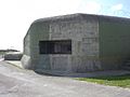
Bunker on Kornwerderzand


Web links
- Kazemattenmuseum website (Dutch)
Individual evidence
- ↑ a b Kerncijfers wijken en buurten 2017 Centraal Bureau voor de Statistiek , accessed on June 19, 2018 (Dutch)
- ↑ Note: After Hoek van Holland , Haringvlietdam and Den Oever, as well as before IJmuiden