Haringvlietdam
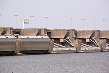
The Haringvliet dam is the sixth structure of the Dutch Delta Works . It closes the Haringvliet , an estuary of the Rhine , with a series of large sluices and lies between Voorne-Putten in the north and Goeree-Overflakkee in the south.
Data on the dam
The widest estuary of the Rhine , the Nieuwe Merwede , and the Meuse reach the North Sea after their confluence via the Haringvliet. The core of the Haringvliet dam is Europe's largest tidal barrier , called “Haringvlietsluizen” in Dutch. It is connected to the south bank by an artificial island, the connection of which with the dike on the island of Goeree-Overflakkee is cut by a shipping canal with a lock . The connection to the island of Voorne-Putten in the north is formed by an embankment.
The tidal barrier consists of 17 openings, each 62 meters wide. In contrast to a classic sluice , a small, precisely controlled amount of salt water from the North Sea is let in at high tide . The runoff of river water into the North Sea at low tide is also dosed. If the water flow of the Rhine when entering the Netherlands (Lobith gauge) is below 1100 m³ / s, the lifting gates remain closed, so that the combined water from Nieuwe Merwede and Maas via the waterways Dordtsche Kil and Noord , as well as the Spui , the Nieuwe Waterweg through Rotterdam and provides enough water here. If more than 9000 m³ / s flow in at Lobith, the gates are fully opened and the vast majority of the runoff from the river system of the Rhine reaches the sea through the gate openings of the Haringvliet dam. Every year around 30 billion cubic meters of river water enter the North Sea, which corresponds to a mean flow rate (MQ) of around 950 m³ / s.
The dam is 5 kilometers long and 56 meters wide. The four-lane road N 57 runs over the dam , which as part of the dam route connects the province of Zeeland with Rotterdam and thus with the province of South Holland .
Construction work
Construction work began in November 1958. A total of 21,800 piles were driven into the ground. After that, the barriers were built from 1961. When these were almost finished, the dam was poured from 1966. Its core consists of 93,000 gigantic concrete blocks that were dropped from a cable car into the water. In 1970 the Haringvlietdam was finished. It was opened on November 15th by Queen Juliana of the Netherlands .
Web links
- Website for the Delta Works (Dutch, German, English, French, Spanish)
Individual evidence
- ↑ Haringvlietsluizen Rijkswaterstaat , accessed on May 31, 2018 (Dutch)
Coordinates: 51 ° 49 ′ 57.7 ″ N , 4 ° 2 ′ 56.9 ″ E

