Delta Works
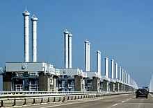
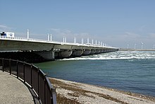
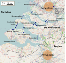
The Deltawerke ( Dutch Delta Works ) are a protection system against floods and storm surges in the Netherlands with a focus on the province of Zeeland . They protect the southern part of the province of Zuid-Holland , the western part of the province of Noord-Brabant and the province of Zeeland. The individual structures of the Delta Works can be found spatially separated from one another on several stretches of coast.
Some dams such as the Oosterschelde barrage are open and are only closed when there is a risk of flooding or storm surges. Others - such as the Brouwersdam - were completely closed, which led to a problematic decrease in the salinity of the onshore water resources. To correct this, a passage was made in the dam after completion, the Brouwerssluis . It was completed on June 1, 1978. It is a type of sewer and is not available for shipping.
history
The reason for the construction of the Delta Works was the flood disaster of 1953 , which killed 1835 people and over 200,000 animals in the river delta in the south of the Netherlands. It was the largest Dutch storm surge disaster since the Elizabeth flood in 1421 .
Before this catastrophe, the required height of the sea dikes was 4.30 meters above the Amsterdam level (NAP); as part of the Delta project, it was set at 7.65 meters above NAP. “This will bring the dikes to delta height”, hence the project name.
To protect the country against such storm surges in the future, the government founded the Delta Commission on February 21, 1953, which drafted the Delta Plan by October 18, 1955 . The law drafted on this basis (“Deltawet”) was passed on May 8, 1958.
In 1958 a movable storm surge barrier was put into operation in the Hollandse IJssel, and in 1961 the Veerse Gat and the Zandkreek were cordoned off. The Haringvlietdam was completed in 1971, the Brouwersdam in the same year . To regulate the flow of water from the arms of the Rhine and Meuse estuaries, the dams had to be provided with large sewer systems. After the completion of the Oosterschelde barrage in 1986 and the Oesterdam , Philipsdam and Bathse Spuisluis ("Bather Siel") in 1987, the Delta Works were completed with the completion of the Maeslant and Hartel barriers in 1997. The cost of the project was 6 billion guilders (around 2.7 billion euros), more than three times as high as estimated.
Adaptation and modification of the coastline
The coastline (bank edge to the North Sea) of the Netherlands has changed drastically as a result of the Delta Works. Measured from Veerse Gatdam near Vrouwenpolder (province of Zeeland ) (51 ° 35'06 "N / 3 ° 37'33" E) and the Haringvlietdam near Hellevoetsluis (province of Zuid-Holland ), (51 ° 50'37 "N / 4 ° 04'16 "E) the coastline - including the islands of Noord-Beveland , Schouwen-Duiveland and Goeree-Overflakkee - was about 355 km. After completion of the Delta works, it is now only about 60 km. This has shortened the coastline of the Netherlands by around 295 km. The Maeslantkering is a barrage to secure the port entrance to the old port of Rotterdam and is regularly open and navigable. In addition, only the combined estuary arms of the Meuse and Rhine (Waal and Lek) are secured. So the barrage does not shorten the coastline. The Hollandse IJssel barrage does not change the coastline either.
Illustrations
Components
The Delta Works consist of the following structures:
- Barrier of the Dutch IJssel (1958)
- Zandkreekdam (1960)
- Veerse Gatdam (1961)
- Grevelendingam (1965)
- Volkerakdam (1969)
- Haringvlietdam (1971)
- Brouwersdam (1971)
- Markiezaatskade (1983)
- Oosterschelde barrage (1986)
- Oesterdam (1987)
- Philipsdam (1987) with Krammerschleusen
- Bather Siel (1987)
- Maeslan barrage (1997)
- Hartel Barrier (1997)
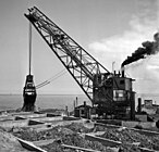
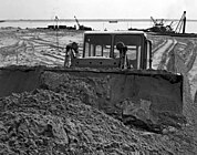
Novel techniques were used to build the Delta Works. The Oosterschelde and Maeslant storm surge barriers in particular attracted a great deal of international attention. The Delta Works have been declared one of the modern wonders of the world by the American Society of Civil Engineers . Even strong water pressure (up to 180 MN) cannot harm the Delta Works because of their stable and massive construction.
See also
Web links
- Delta Works Online
- Privately created website about the construction of the storm surge barrier in the Oosterschelde ( Memento from August 8, 2010 in the Internet Archive )
- Delta Park Neeltje Jans
Individual evidence
- ↑ The Delta Plan on deltawerken.com
- ↑ Data from Google Earth
- ↑ ANWB Waterkaart Zeeland (2009/2010), ISBN 978-90-18-02782-7
