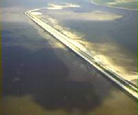
Oesterdam
The Oesterdam is a dam that connects the former islands of Tholen and Zuid-Beveland in the eastern part of the Dutch coastal province of Zeeland . With a length of 10.5 kilometers, the dam is the longest structure in the Delta Plan .
Construction began in 1979, first a work island was washed up and from 1980 the dam was built in stages. In 1986 the dam was closed and, after the road on the dam was completed, it was inaugurated in 1989 by the Royal Commissioner of Zeeland.
This dam was necessary in order to reduce the size of the Oosterschelde basin , as the tides in the Oosterschelde basin were strongly influenced after the opening of the barrage in the estuary . However, due to the reduction in size, the tidal range could be kept fairly constant. Furthermore, the Oesterdam separates the Scheldt-Rhine Canal from the Oosterschelde basin. This makes it tideless and better usable for inland navigation. On the other hand, it is very important for the freshwater balance. At the same time the Markiezaatskade , the Philipsdam with the Krammerschleusen , the Grevelingenam and the Volkerakdam were built. The Oesterdam separated about 1000 hectares from the Oosterschelde, the Markiezaatskade prevented the Zoommeer from expanding to Bergen op Zoom. To the west of the city of Bergen op Zoom there is a connecting lock, the so-called Bergse-Diep-Sluis.
Web links
- Delta Works website - information about the Oesterdam (Dutch, German, English, French, Spanish)
- Oesterdam: Website of the tourist association VVV Zeeland (Dutch, German, English)
Coordinates: 51 ° 29 ′ 9 ″ N , 4 ° 13 ′ 6 ″ E
