Hollandse IJssel
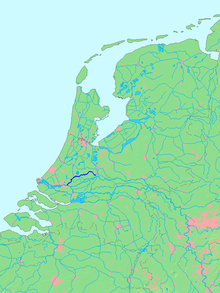
The Hollandse IJssel ( German Dutch Issel ) is a 46 kilometer long river in the Dutch provinces of Utrecht and South Holland . It flows from Nieuwegein via Gouda to Krimpen aan den IJssel , a suburb of Rotterdam . There it flows into the Nieuwe Maas . The Hollandse IJssel is only navigable below Gouda with ships up to 2000 t. Today an average of 0.7% of the Rhine water flows through the Hollandse IJssel.
history
The Hollandse IJssel was originally a branch of the Lek , which began near Nieuwegein. The arm was cut off in the 13th century for two reasons: On the one hand, the lek became larger due to the damming of the Rhine near Wijk bij Duurstede ; on the other hand, the draining of the Dutch moorland required good drainage. However, this could only work if the level of the IJssel was lower. Count Floris V had the Dam bij het Klaphek built in 1285 . Thereupon the Hollandse IJssel threatened to silt up. To avoid this, a connecting canal called Doorslag was built ten years later between the Vaartse Rijn canal, which was built in 1122, and the Hollands IJssel. Nevertheless, the water level in the upper reaches was too low for shipping. That is why the IJssel between Utrecht and Gouda was canalized in the mid-19th century. Since 1954, a dam with a sluice and sluice south-east of Gouda has separated the canalised part of the river, the Gekanaliseerde Hollandse IJssel, from the tide-dependent lower course.
River course
Canalized Hollandse IJssel

In the middle of Nieuwegein, a short canal called Doorslag branches off from the Merwede Canal (see above). From its confluence, the Hollandse IJssel flows in two directions:
Kromme IJssel flows south-west towards Lek and parallel to it as Enge IJssel and then as Lopiker Wetering to Schoonhoven .
The main river flows northwest as the Gekanaliseerde Hollandse IJssel to IJsselstein and from there to Montfoort . She reaches Oudewater via Willeskop . The Lange Linschoten flows there, and the Vlist flows out at Haastrecht . This watercourse comes from Schoonhoven and divides the area between the main arms of the Rhine and the Hollandse Ijssal into the eastern Lopikerwaard and the western Krimpenerwaard . The Hollandse IJssel is responsible for drainage for both areas. Shortly before the Gouda channelized river section at the end lock complex De Waaiersluis that besides the eponymous subjects lock a Siel and since 2004 a pumping station covers.
Tidal river Hollandse IJssel
The tidal influence begins at the fan lock . The tidal range is between 1.80 and 3.30 meters.
Gouwe estuary

The Gouwe flows into Gouda , the water level of which is now mostly below that of the Hollandse IJssel. The estuary consists of several artificial waterways: At the mouth of the eastern city moat, Fluwelensingel, there is a pumping station. The old port lock (at the old customs house / Oude Tolhuis) at the mouth of the Gouwe by name only serves as a sewer. On the western edge of the old town, the Mallegatsluis leads into the western moat known as Turfsingel with the museum harbor. The Julianakanaal opens with two arms about a kilometer further on; the eastern Stroom Canal drains through a pumping station, the western Gouwe Canal flows into the Voorhaven via the Julianaschleuse .
Lower course and barrage
Below Gouda, the river widens and forms the border between the municipality of Zuidplas on the right bank with the districts of Moordrecht and Nieuwerkerk aan den IJssel , and Krimpenerwaard on the left bank with the districts of Gouderak and Ouderkerk aan den IJssel . Finally, the town of Capelle aan den IJssel lies on the right bank and Krimpen aan den IJssel on the left . Two kilometers before it flows into the Nieuwe Maas stood there since 1958, the storm surge barrier factory Dutch IJssel , the oldest member of the Delta Plan . At the mouth is Kralingseveer, opposite is the former island of IJsselmonde.
Tributaries
Landscape and settlements
The origin of the Hollandse IJssel lies in the conurbation of Utrecht , the mouth in the conurbation around Rotterdam . In between it flows through the "Green Heartland" of Holland.
Places:
- Nieuwegein
- IJsselstein
-
Oudewater :
- Snelrewaard
- Oudewater
- Hekendorp
- Haastrecht
- Gouda (almost only on the right)
- Gouderak (left, Krimpenerwaard )
- Moordrecht (right, Zuidplas )
- Nieuwerkerk (right, Zuidplas)
- Ouderkerk (left, Krimpenerwaard)
- Chapel (right)
- Crimping (left)
Web links
- Hollandsche IJssel Rijkswaterstaat (Dutch)
- History of the Hollandse IJssel and how the fan lock works In: goudawaterstad.eu (Dutch)


