Nieuwerkerk aan den IJssel
 flag |
 coat of arms |
| province |
|
| local community |
|
|
Area - land - water |
18.49 km 2 17.28 km 2 1.21 km 2 |
| Residents | 21,595 (Jan. 1, 2017) |
| Coordinates | 51 ° 58 ′ N , 4 ° 36 ′ E |
| Important traffic route |
|
| prefix | 0180 |
| Postcodes | 1261, 2761, 2841, 2903-2905, 2907-2908, 2911-2912 |
Nieuwerkerk aan den IJssel ( ) was a municipality in the Netherlands , province of South Holland . On January 1, 2010, it merged with Moordrecht and Zevenhuizen-Moerkapelle to form the new municipality of Zuidplas .
geography
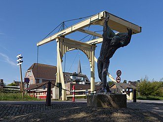
The village is located on the Hollandse IJssel , between Rotterdam (10 km to the southwest) and Gouda . Nieuwerkerk aan den IJssel is the lowest point in the Netherlands with -6.74 m NAP . There is also a memorial in the village.
history
The history of the place is roughly the same as that of the surrounding places, u. a. of the western neighbor Capelle aan den IJssel . In 1953, a dike breakthrough was prevented by the Holland storm flood on February 1st by fastening a boat in a fragile section of the dyke.
economy
Many commuters live in Nieuwerkerk who work in the surrounding cities. There is also a lot of business, u. a. Logistics centers of the companies Rucanor (sports shoes) and Geveke Amsterdam (pumps and machine parts). Tourism is also not insignificant.
traffic
Nieuwerkerk aan den IJssel has a connection (No. 17) to the A 20 motorway between Rotterdam and Gouda.
Nieuwerkerk also has a small train station on the Utrecht – Rotterdam railway line .
Attractions
- Hitland local recreation area with recently planted forest and camping site as well as a signposted hiking trail
- Monument: the lowest point in the Netherlands ( -6.74 m NAP )
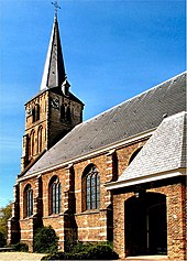
- Old village church: built around 1500, late Gothic
- On the old street s-Gravenweg , which was paved as early as the 17th century, there are some beautiful old farms, one of which houses a small local museum .
- The polder landscape in the area is rich in birds . You can go on a bike tour here. The place has a hotel belonging to the Van der Valk group.
- The place has a marina.
politics
Distribution of seats in the municipal council
| Political party | Seats | |||
|---|---|---|---|---|
| 1994 | 1998 | 2002 | 2006 | |
| VVD | 5 | 4th | 6th | 6th |
| PvdA | 3 | 3 | 2 | 4th |
| CDA | 4th | 3 | 3 | 3 |
| ChristenUnie / SGP | - | - | 3 | 3 |
| Gemeentebelangen Nieuwerkerk | - | 4th | 4th | 3 |
| D66 | 3 | 1 | 1 | - |
| SGP / RPF / GPV | 2 | 2 | - | - |
| total | 17th | 17th | 19th | 19th |
Personalities
- Arie Slob (* 1961), politician
- Maarten Albert Vente (1915–1989), musicologist and organologist
- Leontien Zijlaard-van Moorsel (* 1970), cyclist and four-time Olympic champion, lives in Nieuwerkerk aan den IJssel
- Michael Zijlaard (* 1971), racing cyclist and cycling official
Town twinning
Web links
Individual evidence
- ↑ Kerncijfers wijken en buurten 2017 Centraal Bureau voor de Statistiek , accessed on June 13, 2018 (Dutch)
- ↑ Allocation of seats in the municipal council: 1994–2002 2006 , accessed on June 13, 2018 (Dutch)


