Fortress holland
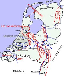
Fortress Holland was a defensive concept in the Netherlands in the years before World War II . In the event of a war, Dutch troops should remain in an area in the western Netherlands until help from friendly foreign troops would arrive. The area would then serve as a bridgehead for these troops.
The area included the cities of Leiden , The Hague , Rotterdam , Dordrecht and Utrecht and was intended as the last line of defense for the Dutch army . The rivers and canals, including the Maas and Waal in the south and the Grebbelinie in the east ( Grebbeberg ), served as natural defensive barriers . The Dutch government tried to secure the fortress of Holland in the north via the fortresses Den Oever and Kornwerderzand .
During the western campaign of the German Wehrmacht in 1940 there were intense battles with German troops , especially in Rotterdam, in the area around The Hague and at Grebbeberg . However, this could not prevent the Dutch armed forces from having to capitulate. The government and royalty fled to Great Britain . Initially only the Dutch colonies overseas remained unoccupied.
Use of the term by the Wehrmacht
On April 7, 1945, the 25th Army of the Wehrmacht, which had gathered in the western Netherlands, was renamed Fortress Holland . Around 150,000 German soldiers were cut off from the German Empire by British and Canadian troops at the end of the war . With the surrender of all German troops in north-west Germany, the Netherlands and Denmark on May 4, 1945 and the Bevrijdingsdag on May 5, 1945, this fortress of Holland finally came to an end.
