
Closing dike
| Closing dike | |
|---|---|


.png)
The Afsluitdijk ( Dutch Afsluitdijk , West Frisian Ofslútdyk ) is a 32 km long dam in the Netherlands between the provinces of Noord-Holland and Friesland . It is considered to be the most important single structure of the Zuiderzee works for land reclamation and coastal protection in the Netherlands and seals off the former Zuiderzee ( South Sea ) from the North Sea . Its construction was completed in 1932 and also included the erection of two large tidal barriers that serve to discharge the incoming fresh water. A motorway (the A 7 ) and a cycle and walkway run along the dam . The barrier dam created the inland waters of the IJsselmeer from the tidal Zuiderzee estuary .
Strictly speaking, the closure dike is not a dike, but a dam, as dykes have a hinterland that is protected by the dyke. The western end is at Den Oever (municipality of Hollands Kroon , province of Noord-Holland) and the eastern end is in Zurich near Harlingen (municipality of Súdwest-Fryslân , province of Fryslân). The municipality of Southwest Fryslân accounts for around 20 kilometers of the closure dike, with the towns of Kornwerderzand and Breezanddijk on artificial islands . The remaining 12 kilometers belong to the municipality of Hollands Kroon.
construction

Most of the Netherlands is below sea level , so without the extensive dyke construction work, half of the country would be under water. Nevertheless, the country was repeatedly hit by devastating storm surges . As early as the 17th century there were therefore plans to damming the Zuiderzee, but these could not be implemented with the technical means available at the time.
At the end of the 19th century, the engineer Cornelis Lely developed the plan for today's dam. But there was resistance from the population and funding was also heavily questioned. It was only after the renewed flood disaster in 1916 that there was more approval among the population for the plans. Lely had meanwhile become the responsible Minister of Transport and created the legal basis for the official planning work with the Zuiderzee Act in 1918. The Zuiderzeewerke were founded for the construction of the final dike and the construction of the polders for land reclamation.
Construction began in 1927. In order to be able to start building the dam from four places at the same time, the two artificial working islands Kornwerderzand and Breezand were created. Two parallel dams made of boulder clay formed the lateral dam feet. Sand was installed in between and the dam was brought up to the level of the water level. On May 28, 1932 at 1:02 p.m., the Grunddeich on the Vlieter was ceremonially closed. Subsequently, it was expanded to the planned height so that the final dike could be officially opened on September 25, 1933.
With the closure of the North Sea Bay Zuiderzee, a large freshwater lake was created over the years, which is referred to in Dutch as the "sea". Accordingly, it was officially renamed the IJsselmeer in September 1932. By building the dike, the dike line in the Netherlands was shortened by more than 200 km, saving the country extensive construction and maintenance work on the dikes of the former Zuiderzee and protecting the heartland with the capital Amsterdam from the floods of the North Sea.
Floods in Amsterdam caused by wind congestion in 1960 testified to the danger that the IJsselmeer still posed. In order to reduce the area affected by the wind ( fetch ), it was decided to build another dam between Enkhuizen and Lelystad . The Houtribdijk (also Markerwaarddijk) was built between 1963 and 1975 and has been an important road link between North Holland, Flevoland and Gelderland since its completion .
Second World War

Casemates were built on the former work island of Kornwerderzand in 1931 and later expanded into a military base. It was so well developed that the numerically outnumbered Dutch army was able to stop the advancing German troops until the kingdom surrendered on May 14, 1940 . There is now a war memorial at that point .
Storm surge 1953
The flood disaster of 1953 , which had devastating consequences in Zeeland , Belgium and England , was the acid test for the dike. Although the dike was heavily used by waves and partially flooded, it withstood the waves and was able to prevent flooding around the IJsselmeer. "That night the final dike paid back its money," was the statement of a politician.
Dike structure
The dike is 32 km long and 90 meters wide. Its height was initially 7.25 meters above the Amsterdam level (NAP = Normaal Amsterdams Peil) and is now approx. 10 meters above the NAP. At the former point of completion (approx. On the western third point) is the Vlieter monument with an observation tower , parking lot and restaurant. The Vlieter was the former fairway between the Zuiderzee and the Wadden Sea . Since the 50th anniversary of the dike's completion, the sculpture of a stone setter has been a reminder of the 5,000 workers who built the dam. A footbridge allows a safe route over the motorway to the Wadden Sea side. The statue of Cornelis Lely, which was previously set up in Den Oever, has also stood here since 2007. There it had to give way to the construction of the motorway.
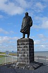
Statue of Cornelis Lely
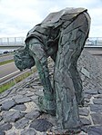
Monument to the stone setter

Vlieter monument with observation tower
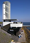
Observation tower


Tide barriers
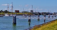
At each end of the dyke a Tidesperrwerk , each in Dutch with sluizen referred, the plural of sluis what both lock and Siel may mean. The Siele (Dutch spuisluis ) discharge the fresh water flowing into the IJsselmeer and are opened for this purpose in the North Sea when the water is low ( ebb ). This regulates the water level in the IJsselmeer. Next to these sluices there are locks ( shutsluis ) for shipping.
The western barrage at Den Oever is called Stevinsluizen . The sluice structure consists of three groups, each with 5 sluice openings of 12 meters wide. Next to it is a shaft lock (length: 120 m, width: 13 m) with the necessary outer harbors. To prevent salt water from entering the IJsselmeer, a veil of air bubbles is placed in the lock chamber.
The eastern barrage at Kornwerderzand is called Lorentzsluizen . For reasons of flow, it is about four kilometers from the Frisian mainland. Two groups with 5 sluice openings each have been erected here as a sewer structure. Because of the heavy sport boat traffic, a smaller lock (length: 67 m, width: 9 m) was built here next to a large shaft lock (length: 137 m, width: 14 m).

Lorentz lock Kornwerderzand (2007)

Small lock Kornwerderzand - behind the big lock (2008)
Kornwerderzand outer harbor - IJsselmeer side (2015)
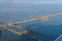
Aerial view of the Stevins lock Den Oever (2013)


.jpg)
Traffic routes
Next to the dike, a road was laid on the dam, which was expanded into the four-lane Rijksweg 7 motorway in the 1970s . When ships pass the locks, the swing bridges must be opened and all car traffic on the dam is interrupted by barriers. Every day more than 9500 vehicles drive over the final dike (status: 2009). On the work island Breezand there is a stop, refueling and turning area. There is also a port of emergency for shipping on both sides of the dike . In addition, there is also the possibility of crossing the final dike by bike on a separate cycle path. However, the cycle path will be closed between 2019 and 2022 due to construction work. As an alternative connection, there is a free bus line that should also allow bicycles to be taken along.
The original plan also provided for a railway line over the dam. But this was not seen as economical. The route that was kept free could be used for the double-lane expansion to the motorway.

Aerial view of the Den Oever lock complex

Closing dike - looking towards the northeast: left Wadden Sea, right IJsselmeer (2016)
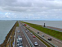
Closing dyke - looking southwest: left IJsselmeer, right Wadden Sea (2007)
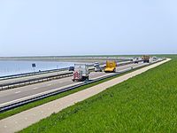
Bend in the dike near Kornwerderzand - looking west (2013)


Project Afsluitdijk
The climatic changes that can be observed around the world give rise to fears that sea levels will rise. Calculations based on this led to the result that there would no longer be enough time at the sluice structures to drain the water from the IJsselmeer into the Wadden Sea. A third sewer structure was considered to be the solution. However, the plan failed due to the lack of financial resources.
In 2006, the Minister of Transport, Karla Peijs, announced that it would undergo major renovations after 75 years . At 10 meters above NAP, the dike is actually too low, since the dyke heights on the North Sea coast are currently 11.5 meters above NAP. Also, the crown and the internal structure cannot withstand the erosion sufficiently . In addition, the lock systems for shipping no longer meet current standards .
After 10 years of planning work, in November 2016 Rijkswaterstaat , the executive authority of the Dutch Ministry of Infrastructure and Environment for the construction and maintenance of roads and waterways, launched the tender for the project to strengthen and modernize the barrier dike. The work should begin in 2018 and be completed by 2022 and secure the final dike against a 10,000-year flood event (e.g. extreme spring tide in combination with a violent northwest storm) by 2050 .

The dike is basically left at the existing height so that it does not have to be widened. It is only increased by 2 meters in some places. Against the rising tides and the higher waves, the dike is reinforced on the entire lake side and at the same time secured against overflow. The locks on both sides of the dike have additional storm surge barriers, which normally remain open. The sewer construction will be reinforced and the locks in all 25 passages will be renewed. In addition, a third larger shipping lock with a width of 25 meters and a length of 150 meters will be built in Kornwerderzand and the fairway deepened into the IJsselmeer.
Instead of a third sewer complex, a pumping station with an output of more than 400 m³ / s is planned in Den Oever . This corresponds to a volume of 10 Olympic swimming pools per minute. The equipment with pumps will take place gradually as required so that the latest technology can always be used. Additional space is reserved for future expansion of the pumping station.
The dike forms a barrier for fish that want to return from the North Sea to the IJsselmeer. That is why a first passage structure for fish was built near Den Oever in 2015. As part of the project, an innovative fish passage is now being built next to the sewer complex in Kornwerderzand. Sand washes up its own ecosystem to achieve a smooth transition from salt water to fresh water. It is estimated that 250,000 fish per year will use the new passage to reach the spawning areas in the IJssel catchment area .
As part of the project, the interaction and storage of various forms of regenerative energy is also being investigated in order to be able to operate the dike in an energy-neutral manner. For this purpose, turbines were installed in a sewer group , as well as a wind turbine and solar collectors . A research project is investigating the possibility of generating energy from the different salt contents of the IJsselmeer and Wadden Sea. In the project, a power plant was installed that generates energy using reverse electrodialysis .
In addition, tourism is promoted and expanded z. B. by building a new cycle path on the lake side (Wadden Sea) or the Waddenpark Fryslân. All work is carried out in close coordination with the adjacent regions (provinces) and their authorities and water boards.
See also
Web links
- De Afsluitdijk Rijkswaterstaat (Dutch)
Individual evidence
- ↑ Disabilities on the final dike
- ↑ Timetable from the bicycle bus
- ^ Andreas Gebbing: Climate protection policy in the Netherlands. (No longer available online.) Westf. Wilhelms-Universität Münster, September 2010, archived from the original on September 19, 2016 ; Retrieved February 20, 2017 .
- ↑ Project overview of the final dike. Retrieved February 4, 2017 (Dutch).
- ↑ The individual projects for the new final dike. Retrieved February 4, 2017 (Dutch).
Coordinates: 53 ° 0 ' N , 5 ° 10' E