
Sand against sea

Sand against the sea ( Dutch zand tegen zee ) is a new construction method for coastal protection in the Netherlands . Extensive sand washes in a natural design form a dune and beach landscape that form a gentle transition from sea to land. The first practical application of this method took place in the Hondsbos dunes in North Holland between Petten and Camperduin . A similar coastal protection project is the sand motor in South Holland , in which a comparable volume of sand was moved.
history
Due to its geographical location, the Netherlands has been fighting with and against the tides of the North Sea since ancient times . Almost a third of the country is below sea level, so that without the extensive dyke construction work, half of the country would be under water. Devastating storm surges repeatedly gave the work severe setbacks. As a result, the dikes were raised further and / or fortified with massive revetments .
The last storm surge in February 1953 clearly showed the weaknesses in dyke construction and the decreasing care in maintaining and maintaining the dykes. To prevent a repetition of such a disaster, the Delta Works Plan was launched, which is the culmination of the major hydraulic engineering projects in the Netherlands. The dyke line was extremely shortened by huge barrier structures in the entire Rhine-Maas delta and all dykes on the North Sea were given a new height of 11.5 meters above NAP ( Normaal Amsterdams Peil ).
future
A rise in the North Sea water level is expected as a result of climate change . That is why people in the Netherlands are thinking about further coastal protection and examining the dykes for their weak points. The basis is a statically determined North Sea water level for an event that occurs once every 10,000 years (10,000-year flood). B. an extreme spring tide in combination with a violent northwest storm. A spring tide is caused by certain constellations of moon and sun and brings significantly higher tidal water levels than normal. If there is a persistent north- westerly storm at hurricane strength, the water will be prevented from running off at low tide due to a build-up of wind , so that even higher water levels must be feared with the next high tide .
The sea dike between Petten and Camperduin
A severe storm surge in the Middle Ages destroyed the dune area between Petten and Camperduin in 1421. As a replacement, the Dutch built the sea dike "Hondsbossche und Pettemer Zeeweering". But the sand dike kept breaking. It was not until 1880 that the dike was given its current shape, and in the years that followed, it was heavily fortified by asphalt and basalt blocks on its lake side . With the Delta Plan from 1977 to 1981, the height of the dyke was again adjusted here.

Sea dike looking north (2006)

Sea dike looking south (2005)
Dike fastening


Hondsbossche dunes
Investigations in 2004 showed that the "Hondsbossche" is one of eight weak links in the dyke chain on the Dutch coast and would not withstand a 10,000-year flood event . Since people in the Netherlands had been thinking about new methods of coastal protection since the end of the 20th century, the responsible public administrations (Rijkswaterstaat, provincial governments and water associations) decided not to carry out traditional dike reinforcement. Instead of further artificial fortifications and dike heights, a 250-meter-wide strip of dunes and beach should be created in front of the old dike.
The construction work was carried out between 2013 and 2015 and the Hondsbos dunes were created with 35 million cubic meters of sand. They form the connection between the dune areas of the Zwanenwater and the Schoorlser Dunes , the widest nature area along the Dutch coast. The now flat beach causes the waves to break far off the coast, so that the impact of the waves on the beach and the dunes is greatly reduced. This is a natural and sustainable solution. On the one hand, the sand follows the movement of the water as the sea level rises and, on the other hand, sand that has been removed can easily be replaced. With the coastal reinforcement with sand, nature helps with the work and thereby makes the measures more cost-effective.
Instead of a barely usable and unattractive stretch of coast, a new eight-kilometer-long sandy beach was created, which was given an artificial lagoon at the southern transition to the Schoorlser dunes . With the creation of new bike and hiking trails, beach exits and viewing dunes, the attractiveness has been increased and new opportunities for recreation and tourism have been created.
With the sand deposit, the municipal area of Petten expanded and reached the former village center, which was lost centuries ago in a storm surge. As a reminder, a group of wooden steles was set up on the beach at the site of the village church .
Nature also benefits from new natural zones such as the alternation of calm, moist dune valleys with dry dune ridges. The old dike was integrated and remains visible to tourism. During the ongoing monitoring, the birds are counted and the plants that are supposed to hold back the drift sand are examined. The height and width of the dunes and the beach are checked regularly to prove the reliability of the coastal protection. The information center "zand tegen zee" in Petten shows the history and the construction work in words and pictures.

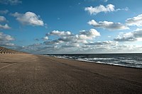
The new panorama dune on the beach of Petten - looking north (2015)
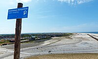
Hondsbossche dunes with visible old dike - view from Panoramadüne in south direction (2015)
The position of the old village church of Petten (2017)


See also
Web links
- The sea dyke Hondsbossche and Pettener Zeeweering (Dutch)
- Map of the weak dykes (Rijkswaterstaat May 2014)
- Project Kust op Kracht (Dutch)
- Information Center Zand Tegen Zee Coast in Petten (Netherlands)
- Kust op cracks in the film
- Sand engine in the film
Individual evidence
- ^ Andreas Gebbing: Climate protection policy in the Netherlands. (No longer available online.) Westf. Wilhelms-Universität Münster, September 2010, archived from the original on September 19, 2016 ; Retrieved February 20, 2017 . Info: The archive link was inserted automatically and has not yet been checked. Please check the original and archive link according to the instructions and then remove this notice.
- ↑ Ronny Vergouwe: The National Flood Risk Analysis for the Netherlands. (PDF) (No longer available online.) Rijkswaterstaat VNK Project Office, archived from the original on March 21, 2016 ; accessed on January 23, 2017 (English). Info: The archive link was inserted automatically and has not yet been checked. Please check the original and archive link according to the instructions and then remove this notice.
- ↑ Zwakke Schakels. (No longer available online.) Rijkswaterstaat Project HWBP-2, archived from the original on March 18, 2016 ; Retrieved January 23, 2017 (Dutch). Info: The archive link was inserted automatically and has not yet been checked. Please check the original and archive link according to the instructions and then remove this notice.
- ↑ Annette Birschel: Flood protection: The Netherlands build beaches against climate change - WELT. welt.de, November 10, 2014, accessed on January 23, 2017 .
- ^ Kust op kracht. Gemeente Schagen, accessed February 4, 2017 (Dutch).
Coordinates: 52 ° 44 ′ 41 ″ N , 4 ° 38 ′ 43 ″ E