
Schoorlser dunes
|
NSG Schoorlse Duinen
|
||
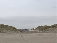
 Dune landscape looking north |
||
| location | Bergen Municipality (North Holland) , North Holland , Netherlands | |
| surface | 17.37 | |
| WDPA ID | 555514227 | |
| Natura 2000 ID | 555536924 | |
| FFH area | 17.37 | |
| Geographical location | 52 ° 42 ' N , 4 ° 40' E | |
|
||
| Setup date | 2010 | |
| administration | State Forest Administration (Staatsbosbeheer) | |


The Schoorlser Dunes ( Dutch Schoorlse Duinen ) are a nature reserve in North Holland northwest of Alkmaar between the North Sea and the village of Schoorl . The five-kilometer-wide dune area borders in the north on the Hondsbos dunes, which were washed up in 2013-2015, and ends after about six kilometers in the south on the North Holland dune reserve . The radar dune rises from it, at 54 meters the highest dune in the Netherlands .
nature
At the beginning of the 20th century, wind and sand still had free play in the area and the dunes were constantly reshaping. After that, the Dutch forest administration (Staatsbosbeheer) began planting, so that today the dunes are interspersed with pine and deciduous forests . There is also an open heathland and smaller lakes and moors. Tiny white orchids bloom in summer and the heather blooms in purple in autumn. Salt -tolerant plants such as the beach aster or sea cabbage can be found on salt marshes . The dune area offers nesting space for the green woodpecker , woodcock and the very rare night swallow . Sand lizards , grave bees and digger wasps live in the sand .
tourism
The visitor center "Het Zandspoor" of the Dutch forest administration is located in Schoorl and offers maps and information material. This is where the various hiking routes start , over 70 kilometers of which are marked according to the junction system. The North Sea Trail also crosses the undulating dune landscape. For cyclists, paved bike paths have been laid out and signposted, such as the Schoorlser Düneradweg The route offers interesting facts about the dunes and leads along the most interesting points. There is an attractive and challenging route for mountain bikers, which leads from Aagtdorp 15 kilometers over many gradients through the sandy dune area.
Attractions
One of the three large climbing dunes, the Klimduin, where sand competitions also take place, ends in Schoorl. Children can roll down there with great joy or can toboggan here in snow. Another attraction is the notch (Dutch: De Kerf) on the coast about two kilometers north of Bergen aan Zee . There an artificial bay was dug in the dunes so that salt water can run into the dunes at high tide . The current carries sand into and out of the notch, constantly reshaping the landscape. In this way, nature itself should grow and develop further. The forest administration calls this dynamic nature protection. The beach itself cannot be reached by car from Schoorl and is therefore relatively quiet and secluded even in summer. With the washing up of the Hondsbos dunes , an artificial lagoon was created at the northern end of the nature reserve near Camperduin , which has a connection to the North Sea for water exchange. In it, children can enjoy the water in a relatively safe manner.
photos

Dune landscape

Dune landscape

Sand race on the Klimduin
The 'notch' on the beach
.JPG)
.JPG)


Web links
- The edge of the dune in Schoorl (Dutch)
- Discover Schoorl
- Schoorl and surroundings - vacation in North Holland
- "Schoorlse Dünen" nature reserve
- World Database on Protected Areas - Schoorlse Duinen nature reserve (English)
- World Database on Protected Areas - FFH area Schoorlse Duinen (English)
Individual evidence
- ↑ The Schoorlser Dune Cycle Path. (PDF) (No longer available online.) Formerly in the original ; accessed on January 28, 2017 . ( Page no longer available , search in web archives ) Info: The link was automatically marked as defective. Please check the link according to the instructions and then remove this notice.