Zuiderzee

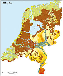
The Zuiderzee [ ˈzɔɪdərzeː ] (also (outdated) Zuider Zee , Zuidersee , Südersee ; West Frisian Sudersee ; Dutch [ ˈzœydərzeː ]) was a shallow, only 4 m to 5 m deep sea bay of the North Sea, mostly in the area of today's IJsselmeer , in the northwest of the present-day Netherlands . It reached about 100 km inland, was up to 50 km wide and covered 5000 km². The name means "southern sea" in contrast to the North Sea (in Dutch and Low German , zee means "sea, the sea" and meer "the lake"). Both names are of Frisian origin, for which both seas are north and south of their settlement area. By damming today's IJsselmeer and some other lakes (therefrom are Ijmeer , Veluwemeer , Gooimeer , Markermeer , Drontermeer , Eemmeer and Ketelmeer ) emerged.

history
The Romans were already familiar with a boggy , large-scale water landscape in this area, even if the actual lake, called Lacus Flevus , was probably much smaller than the later Zuiderzee. The Roman general Drusus had around 12 BC Establish the so-called Drusus Canal (fossa Drusiana) from the Rhine to the Flevo Lake in order to shorten the route of the Roman fleets to the North Sea. This sea connection played a major role during the Germanicus campaigns (14 to 16 AD). This lake landscape probably arose since the seventh century BC. Even then, when storm surges occurred, the water penetrated far into the flat and low-lying land, in order to gradually erode the bog behind the dunes when it returned. On the other hand, the lake system was increasingly expanded by the tributaries of the IJssel (right estuary arm of the Lek , on the German side the Issel on the right Lower Rhine) and other streams and rivers, so that over time a large freshwater flow towards the north was formed. The Flevo became considerably larger over time and was soon called Almere (Aalsee). (Today Almere is the name of a town in the province of Flevoland .)
With the Julian Flood in 1164, the All Saints Flood in 1170 and finally with the floods of 1219 ( First Marcellus Flood ) and 1228, the salt water broke into the area - the naturally created sand dike was broken, and the inland water created a bay in the north of the Netherlands . With the erosion of the swamp floor of the new sea, the Waddenzee (Wadden Sea ) also formed on the south side of today's West Frisian Islands. After the annexation of the Kingdom of Holland by Napoleon Bonaparte , there was the the 1,811 to 1,814 French Empire belonging Zuyderzée .
Several land reclamation projects have been developed in the Zuiderzee since the mid-19th century. Jakob Kloppenburg and Pieter Faddegon published a first sketch in 1848. They wanted to build a dike from Enkhuizen to Stavoren and connect all the islands from Texel to the Ems with a dam. The designs by Bernard Pieter Gesinus van Diggelen from 1849 and by Thomas Joannes Stieltjes from 1870, which provided for a “ final dike ” ( Afsluitdijk ), were more realistic and the starting point for the following planning .
Only with the construction of the artificial “final dike” in 1932 was an inland waterway created again. The Zuiderzee actually became the IJsselmeer ("the IJsselsee") on May 28, 1932 at 13:02 when the last gate (De Vlieter) of the dike was closed. The official renaming took place on September 20. Subsequently, parts of the former Zuiderzee were drained as polders ( Zuiderzeewerke ), including today's province of Flevoland including the Northeast Polder ( Noordoostpolder ) with the former islands of Schokland and Urk . The main initiator of this work was the engineer and politician Cornelis Lely , after whom the Flevoland provincial capital Lelystad is named. The largest city on Flevoland is called Almere and belongs to the catchment area of Amsterdam . As an additional area for this metropolitan area, Flevoland is more important today than as the agricultural area for which it was originally intended.
The name Zuiderzee can be found on historical maps and documents up to the early 20th century and is only used today in a historical context. The current satellite photo, which shows the extent of the land area gained in comparison, shows the IJsselmeer .
See also
literature
- VJP de Blocq van Kuffeler: The final dam of the Zuidersee. In: Journal of the Association of German Engineers , Volume 73, No. 30 (July 27, 1929), pp. 1041-1050.
- Franz Dülberg : The Zuidersee factory of the Dutch. In: Atlantis: Länder, Völker, Reisen 4th year, issue 8 (August 1932), pp. 456–463.
- Jean-Claude Boyer: Zuiderzee (le) . In: La Grande Encyclopédie . 20 volumes, Larousse, Paris 1971–1976, pp. 14807–14809 (French).
Web links
- Illustration by Frans Hogenberg from 1576: It has already been torn down, a scharmutzel on the Suder See, between the Princen of Vranien, and that of Alba outside of Hispania, ... ( digitized version )
Footnotes
- ^ Brandenburg-Prussia in the 18th century (map). In: G. Droysens Historischer Handatlas. Berlin 1886.
- ^ PA Buuren: The drafts for draining the Zuiderzee in Holland . In: Deutsche Geographische Blätter , vol. 12 (1889), pp. 21–48, here pp. 31–32. ( Digitized version ).
- ^ PA Buuren: The drafts for draining the Zuiderzee in Holland . In: Deutsche Geographische Blätter , Vol. 12 (1889), pp. 21–48, here pp. 32–34 (on van Diggelen) and pp. 38–39 (on Stieltjes). ( Digitized version ).
Coordinates: 52 ° 50 ′ 0 ″ N , 5 ° 20 ′ 0 ″ E
