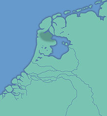
All Saints Flood 1170
The All Saints Flood in 1170 caused extensive devastation on the Dutch and East Frisian coasts on November 1st and 2nd, 1170 . It was one of the largest historically known storm surges on the North Sea .
The flood followed a very hot and long summer. The North Sea broke through the Dutch coast south of what is now the island of Texel , separating both Texel and Wieringen from the mainland and expanding the Zuiderzee , which was caused by an earlier storm surge . Between Texel and Wieringen, the flood tore so much bog out of the “Moerwaard”, the marsh bog between Wieringen and Texel, into the North Sea that the Marsdiep lake was created from a previous bog river and the two islands were separated from each other. From Almere, which was previously influenced by fresh waterbecame the salty Zuiderzee. In the period from this storm surge to 1193, the western Wadden Sea emerged in the form it kept until the beginning of the 20th century. The storm surge was so strong that the water level in the city of Utrecht fluctuated with the tides and whiting swam in it.
According to one theory, the 45 kilometers long and 25 kilometers wide island of Bant off the mouth of the Ems was torn into several parts on the East Frisian coast , from which the islands of Borkyn ( Borkum ), Juist , Buise (disappeared in the 17th century) and Oesterende (today Norderney ) as well as the island of Bant, which disappeared around 1750. Other sources connect this incident with other storm surges of the Middle Ages .
Web links
- zeeinzicht.nl: 1170 - All Saint's Flood , accessed on August 10, 2012
Individual evidence
- ↑ Christian Kuß : Yearbook of memorable natural events in the duchies of Schleswig and Holstein from the 11th to 19th centuries (Volume 1, 1825) p. 9
