Marsdiep
| Marsdiep | ||
|---|---|---|
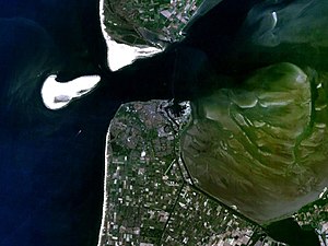
| The Marsdiep, at low tide, between the island of Texel in the north and Den Helder in the south; the Noorderhaak sandbank is on the left in the picture | ||
| Connects waters | Zuiderzee | |
| with water | North Sea | |
| Separates land mass | Texel | |
| of land mass | North Holland | |
| Data | ||
| Geographical location | 52 ° 58 '48 " N , 4 ° 46' 12" E | |
|
|
||
| Smallest width | 4 km | |
| Greatest depth | 45 m | |
| Coastal towns | The hero | |
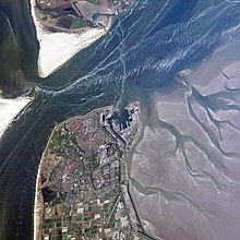
The Marsdiep is an approximately 4 km wide strait or a sea gate between the island of Texel and Den Helder on the Dutch mainland. It is the connection between the North Sea and the Zuiderzee and the southernmost and westernmost connection between the North Sea and the North Sea-Wadden Sea . The Marsdiep was of great historical importance, as all shipping traffic from the important Dutch ports of Amsterdam , Enkhuizen and Hoorn went through the Marsdiep. Because of this strategically important location, Den Helder has been the base of the Royal Netherlands Navy since Napoleonic times .
It is believed that the Marsdiep was created as a sea channel by the All Saints Flood of 1170 , when the North Sea broke through between Texel and Den Helder and made Texel an island. Before it was a small river, the "Maresdeop" (from mare = sea and deop = deep), which flowed into the former Wieringermeer . In the course of time since 1170, the Marsdiep gradually migrated further south. The mouth on the North Sea side is divided into two branches by the large Noorderhaaks sandbank, which is in front of it, but is approaching at a speed of about 100 meters per year : the Molengat runs between Noorderhaaks and Texel , while the southern branch between the Noorderhaaks and the old whaling village Huisduinen consists of the Breewijd, the Schulpengat and the Westgat.
The tidal current turns the Marsdiep into a torrential river for hours every day when the outflow or inflow water reaches a speed of 5 to 7 knots . This regularly recurring and strong current ensures that the Marsdiep is not silted up or silted up , but rather deep: to the northwest of Den Helder it is 45 meters deep.
The Marsdiep is a paradise for fishermen and water sports enthusiasts. Windsurfers will find excellent conditions in westerly winds and running water: since the retreating water from the Wadden Sea has to force its way through the Marsdiep at low tide , there is a strong current here, moving out into the open sea, and the westerly wind creates short, steep ones Waves that make excellent lift off ramps.
The Marsdiep each hour 6:00 to 21:30, during rush hours every half hour by two car ferries of the TESO ( T Exel E strength S toom boat O nderneming) in 20-minute drive between Den Helder and the small fishing village of 't Horntje at the south end crossed by Texel. The Royal Netherlands Institute for Sea Research (NIOZ) is based at the ferry terminal in 't Horntje.
Special
In May 2007, a lost humpback whale enjoyed the prawns in Marsdiep before swimming back into the open sea.
On August 20, 2008, the second and final stage of the international sailing classic " Tall Ships' Races " ended in Den Helder. The participants, among them almost all sailing training ships in Europe, came from Bergen , stayed three days in Den Helder, and then held their impressive “Parade of Sail” on the Marsdiep on August 23rd.
literature
- Dirk Meier: The North Sea Coast - History of a Landscape , Boyens Medien, Heide, April 2006, ISBN 3-8042-1182-8 , ISBN 978-3-8042-1182-7


