Noorderhaaks
| Noorderhaaks | ||
|---|---|---|
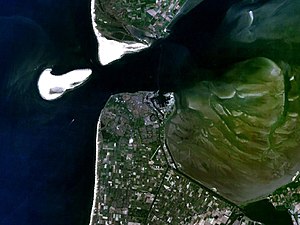
| Noorderhaaks left, the island of Texel in the north, Den Helder in the south (2005) | ||
| Waters | North Sea | |
| Archipelago | West Frisian Islands | |
| Geographical location | 52 ° 58 '18 " N , 4 ° 40' 10" E | |
|
|
||
| surface | 5 km² | |
| Residents | uninhabited | |
| Noorderhaaks sandbank as seen from Den Helder | ||
The Noorderhaaks , also called Razende Bol , is a sandbank ("plate") with an area of approx. 5 km², which was created by the tidal currents between the North Sea and the island of Texel . The water flowing at low tide from the Marsdiep , the strait between Texel and Den Helder , meets the rising tide from the North Sea, the two currents neutralize each other and the sand in the North Sea water sinks. Sand plateaus of this type slowly move in the direction of the flood stream. About a century ago there was another sandplate, Onrust, on the site of today's Noorderhaak, which joined the southern end of Texel at the beginning of the 20th century.
The Noorderhaaks moves at a speed of 100 meters per year in the direction of Molengat (the approximately 650 m wide passage between Texel and Noorderhaaks) and Marsdiep, but it is not certain whether it will also join Texel - without human intervention. The current in Molengat is still quite strong and the distance between Texel and the Noorderhaaks has not narrowed in recent years. It therefore seems more likely that the Noorderhaaks will spread along the Texel coast in a northerly direction.
The higher areas of the sandbank are only flooded during storm surges . Seals , gray seals and birds are regular guests on the Noorderhaaks because of the tranquility . The sandbar is also a training area for the Dutch armed forces . Since 2006, part of the sandplate has been temporarily closed to the public, in order not to disturb the approximately 120 gray seals resting there. The winter target practice of the Navy was also stopped so that the gray seals with their young are not frightened.
The Noorderhaaks and the Zuiderhaaks further south together form the so-called Haaksgronden . They are also so far untouched in terms of water management and are not part of the coastal protection , which is unusual in the Netherlands.
Coastal protection proposal
In order to protect Texel against erosion and to save the high costs of the annual sand flushing on the southern tip of the island (about 4.5 million euros annually), the landscape architect Lieneke van Campen (* 1973) suggested in her thesis at the Academy for Architecture Amsterdam in 2005 proposed to split the Noorderhaaks into two parts. A 7-meter-deep channel would be dug through its northern extension with cutter dredgers , and the sand thus obtained would be piled up on the north side of the new channel, up to a height of about 15 meters. The larger southern part of the Noorderhaak would remain relatively stable in its current position, while the separated northern part, raised with the sand from the channel, would join Texel over the course of about 20 years through wind erosion and further sand deposits.
Individual evidence
- ^ Van Campen, 2005
- ↑ She was nominated for the Archiprix 2006 by the Academie von Bouwkunst Amsterdam. Jaarboek Academie van Bouwkunst Amsterdam 2004-2005, pp. 266-267


