
Vlieland
| Vlieland | ||
|---|---|---|
 |
||
| Waters | German Bight , North Sea | |
| Archipelago | West Frisian Islands | |
| Geographical location | 53 ° 15 ′ N , 4 ° 57 ′ E | |
|
||
| length | 20 km | |
| width | 2.3 km | |
| surface | 36.16 km² | |
| Highest elevation |
Vuurboetsduin (Vuurtorenduin, "lighthouse dune") 45 m |
|
| Residents | 1072 (April 1, 2016) 30 inhabitants / km² |
|
| main place | Oost-Vlieland | |

 flag |
 coat of arms |
| province |
|
| mayor | Tineke Schokker ( CDA ) |
| Seat of the municipality | Oost-Vlieland |
|
Area - land - water |
315.8 km 2 35.44 km 2 280.36 km 2 |
| CBS code | 0096 |
| Residents | 1,141 (Jan 31, 2019) |
| Population density | 4 inhabitants / km 2 |
| prefix | 0552 |
| Postcodes | 8899 |
| Website | Homepage of Vlieland |
 |
|
The island of Vlieland , which belongs to the Netherlands, is one of the five inhabited West Frisian Islands . On January 31, 2019, it had a population of 1141.
geography
To the west of Vlieland is the island of Texel and to the east is the island of Terschelling , all of which are in the Wadden Sea of the North Sea .
The length of the beach is about 20 kilometers and the cycle path network has a total length of 26 kilometers. The highest point is marked by the Vuurboetsduin (Vuurtorenduin, "lighthouse dune") at 45 meters, on which the Vuurduin lighthouse stands. Other high dunes are Poterslid (31.9 meters), Kooispleklid (29.5 meters) and Kaap-Bol (26 meters).
There is a village on the island, Oost-Vlieland. There is also the oldest house on the island, Tromp's Huys , a former admiral's office to monitor merchant shipping, now a museum. Next to the church on the Kerkplein is the Armhuis from 1662 , which was used as a poor, widow's and orphanage until 1950. The lighthouse, like the lighthouse on Texel, is open to visitors during the season. The village of West-Vlieland , which is located further to the west and no longer exists , was abandoned in 1736 after flooding there several times in the previous years.
traffic
A ferry connection to the mainland exists between Oost-Vlieland and Harlingen . There is also a ferry connection from Texel to Vlieland in summer. The ferry on the sandbank "Vliehors" creates, which follows west of Vlieland where passengers with a fording capability will be picked up off-road vehicle and brought to the island over the sandbar. The island is basically car-free. Only islanders can get a special permit to operate motor vehicles. The ferry service from Harlingen or Terschelling does not transport cars or motorcycles.
In the west of the island is Het Posthuys ("the post office"). Het Posthuys is the old station for changing horses for the post rider on the route to Amsterdam. Mail from the sailors in the roadstead in front of Vlieland was brought to Amsterdam via Vlieland, Texel and North Holland in earlier centuries . Today, Het Posthuys is a popular place for excursions.
In the east, near the ferry port, there is a new port for sailing and motor boats that was built in 2007.
The island is considered an autoluw , which means that only residents can apply for a permit to operate a motor vehicle. To the west of the island, in the De Vliehors nature reserve , is the largest training area for the Royal Air Force in the Netherlands. During the week it can happen that the dropping of bombs (also armed ones) is practiced. The area is then marked with red flags. Only on the weekends there is no practice.
The Vlieland helipad is located here .
politics

Distribution of seats in the municipal council
The municipal council has been formed as follows since 1986:
| Political party | Seats | ||||||||
|---|---|---|---|---|---|---|---|---|---|
| 1986 | 1990 | 1994 | 1998 | 2002 | 2006 | 2010 | 2014 | 2018 | |
| Nieuw Liberaal Vlieland | - | - | - | - | - | - | - | - | 4th |
| GroenWit | - | - | - | - | - | - | - | 2 | 3 |
| Algemeen Belang Vlieland | 1 | 2 | 2 | 3 | 3 | 3 | 3 | 3 | 2 |
| VVD | 3 | 3 | 5 | 3 | 4th | 3 | 4th | 4th | - |
| PvdA | 3 | 2 | 2 | 3 | 2 | 3 | 2 | - | - |
| total | 7th | 7th | 9 | 9 | 9 | 9 | 9 | 9 | 9 |
mayor
Tineke Schokker ( CDA ) has been in office since March 31, 2015, initially as provisional and from October 12, 2017 as official mayor. The councilors Rients Hoekstra ( VVD ), Elsje de Ruijter (GroenWit) and the municipal secretary Robert Lanting are among their staff .
Culture
The music and culture festival Into The Great Wide Open has been taking place on the first weekend in September since 2009 .

"Vuurduin" lighthouse on Vlieland
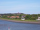
The place Oost-Vlieland from the tidal flats
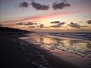
Beach

Ferry between Vlieland and Texel


literature
- Geert-Jan Bron, Wat & Hoe - Wadden Island . 2nd edition, Kosmos Uitgevers, Utrecht / Antwerpen 2007, ISBN 978-90-215-1127-6
Web links
- Website of the municipality (Dutch)
- Website of the Vlieland Tourist Office (Dutch, German, English)
Individual evidence
- ↑ Bevolkingsontwikkeling; regio per maand . In: StatLine . Centraal Bureau voor de Statistiek (Dutch)
- ↑ Flickr: Vlieland - top Poterslid- paal AP
- ↑ Geert-Jan Bron, Wat & Hoe - Waddeneilanden , pp. 82–90
- ↑ http://www.vlieland.net/index.php?pid=historie Website of VVV Vlieland (Dutch)
- ↑ vlieland.org
- ↑ http://www.defensie.nl/onderwerpen/oefeningen/inhoud/oefengebied-luchtmacht (Dutch)
- ↑ Result of the local elections: 2014 2018 , accessed on June 20, 2018 (Dutch)
- ↑ Allocation of seats in the municipal council: 1986–2002 2006 2010 2014 2018 , accessed on June 20, 2018 (Dutch)
- ^ Nieuwe burgemeester in Vlieland. In: Rijksoverheid. August 24, 2017, accessed June 20, 2018 (Dutch).
- ^ College Gemeente Vlieland, accessed June 20, 2018 (Dutch)
- ^ Festival website (Dutch, English, French), accessed April 13, 2018
Noorderhaaks | Texel | Vlieland | Richel | Terschelling | Griend | Ameland | Rif | Engelsmanplaat | Schiermonnikoog | Simonszand | Rottumerplaat | Rottumeroog | Zuiderduintjes