
Vuurduin
| Vuurduin | ||
|---|---|---|
 |
||
| Place: | Oost-Vlieland | |
| Location: | on the Vuurboetsduin | |
| Geographical location: | 53 ° 17 '45 " N , 5 ° 3' 30" E | |
| Height of tower base: | 42 m | |
|
||
| Identifier : | Iso W 4s | |
| Scope knows: | 20 nm (37 km ) | |
| Optics: | Belt lens | |
| Operating mode: | three mercury vapor lamps | |
| Function: | Sea fire | |
| Construction time: | 1876 | |
| Operating time: | 1909 | |
| International ordinal number: | B 0894 | |

Vuurduin is the name of the Dutch lighthouse on the Wadden Sea island of Vlieland . Despite its small size, its elevated location on the Vuurboetsduin results in a clearance height of around 54 meters above sea level.
history
The oldest known reference to a beacon on the island of Vlieland dates from 1462. Before the current tower was erected, a stone tower from 1836 stood on this spot. Before that there was a beacon on wooden posts.
Tower currently
The red-brown cast iron tower originally stood on the North Sea Canal as the location Vuurtoren (German low lighthouse ) of the two lighthouses of IJmuiden . The construction with a round cross-section and a slightly conical shaft comes from the pen of Quirinus Harder , the architect of the Dutch shipping authority for pilotage ( Dutch Nederlands Loodswezen ). It was built in 1878 by DA Schretlen & Co from Leiden . Because the height of the tower was too high as a lower light in IJmuiden , it was decided to remove the upper 10 meters including the lantern . The entire component was brought to Vlieland in 1909 and erected on the 42 meter high Vuurboetsduin. Below the lantern, the tower has a walk-in balcony all around . The owner is Rijkswaterstaat , the Dutch authority for the construction and maintenance of roads and waterways.
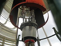
The lighthouse operation is automated and remote controlled. Since 1973, three mercury vapor lamps have been used as the light source, surrounded by a ring-shaped Fresnel lens (belt lens). The light lights up for two seconds at night and then pauses for two seconds. This identifier is generated by a rotating screen which, due to its rotating speed, covers or releases the light for two seconds. With a light intensity of 100,000 candela , a range of 20 nautical miles (37 kilometers) is achieved.
Since 1980 the tower has been protected as a cultural monument as a Rijksmonument and has been partially open to the public since 1990. During the opening hours, a lighthouse keeper offers guided tours in the lighthouse.
In front of the tower below the lantern there has been a viewing platform on stilts since 1950. The platform can be accessed at any time via stairs and offers a wide view of the North Sea and the island. Weddings can be held in the closed part of the building.
Old lantern
In 1986 Rijkswaterstaat carried out an extensive renovation of the lighthouse and replaced the lantern with a plastic structure . The old copper lantern weighing 2500 kilograms was sold. The people on Vlieland did not agree to the sale and the lantern could be bought back after 25 years. Since then, the light dome with a diameter of four meters and a height of around 5.5 meters has stood as a kiosk on a mini golf course in Oost-Vlieland.
Location of the old lantern 53,297 ° N 5,077 ° E

Viewing platform
Lamps


.jpg)
See also
Web links
- Vlieland lighthouse on: vlieland.net (Dutch)
Individual evidence
- ↑ Vuurduin Vlieland lighthouse in: vuurtorens.org (Dutch)
- ↑ Vlieland lighthouse at: pharologie.de
- ↑ Vuurduin in Oost Vlieland in: rijksmonumenten.nl (Dutch)
- ↑ Vlieland dome back in: flickr.com/ (Dutch)