Rottumerplaat
| Rottumerplaat | ||
|---|---|---|
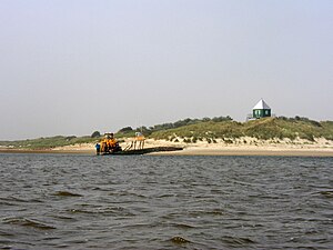
| Rottumerplaat with observation tower | ||
| Waters | North Sea | |
| Archipelago | West Frisian Islands | |
| Geographical location | 53 ° 32 '15 " N , 6 ° 29' 15" E | |
|
|
||
| length | 3 km | |
| width | 2 km | |
| Residents | uninhabited | |
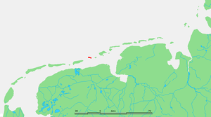
| Location within the Frisian Islands | ||
The Rottumerplaat is an uninhabited dune island in the Dutch Wadden Sea . The West Frisian island belonged to the municipality of Warffum , which became part of the municipality of Eemsmond (since 2019 part of Het Hogeland ) in the province of Groningen on January 1, 1990 .
The island became famous after the writers Jan Wolkers and Godfried Bomans each lived there for a week in 1971 and published their experiences later.
location
To the north of the island is the North Sea with the Hubert gat , to the south the Wadden Sea and Boschgat, to the west is the West Frisian island of Schiermonnikoog and to the east the dune island of Rottumeroog . The Rottumerplaat is the northernmost point in the Netherlands.
history
The Rottumerplaat was built around 1833, originally as a sandbank . Around 1860 the site was named Rottumerplaat . In 1950, the Rijkswaterstaat created a dike, as it was planned as a base for the further dike in the Wadden Sea. Like Rottumeroog, the Rottumerplaat is moving further east. Compared to other small islands in the Wadden Sea, it migrates comparatively quickly. From 1980 to 2000 their average change in position was 75 meters per year and between 2004 and 2012 it was a remarkable 56 meters per year.
From 1965 to 1985 the island grew to 900 hectares, which has now stabilized. In the past ten years, numerous dunes have also been created in the northeast of the island . The Rottummerplaat is uninhabited and access is prohibited. The administration is carried out by the Rijkswaterstaat , Staatsbosbeheer and the Ministerie van Landbouw, Natuur en Voedselkwaliteit . In 1991 it was decided that Rottumeroog and Rottumerplaat could only be entered twice a year.
fauna
The Rottumerplaat is, like Rottumeroog , an important resting place for the Sanderling ( Calidris alba ), Alpine beach runner ( Calidris alpina ) and the Kentish plover ( Charadrius alexandrinus ). It is also a breeding area for eider ducks ( Somateria mollissima ), shelduck ( Tadorna tadorna ), arctic tern ( Sterna paradisaea ), common tern ( Sterna hirundo ), little tern ( Sterna albifrons ) and ringed plover ( Charadrius hiaticula ). The rare sandwich tern ( Sterna sandvicensis ) had also been observed from 1996 , but it has disappeared for several years.
Godfried Bomans and Jan Wolkers
There is a hut for ornithological stations on the island. In 1971 the writers Godfried Bomans and Jan Wolkers each spent a week as a bird watcher; Bomans from July 10th to 17th and Wolkers from July 17th to 24th. Her only contact with the outside world was daily radio contact with VARA employee Willem Ruis . Wolker processed his experiences in the book Groeten van Rottumerplaat (1971). Bomans' diary appeared under the names Op Reis rond de Wereld en op Rottumerplaat (1972) and Dagboek van Rottumerplaat (1988).
Web links
Individual evidence
- ↑ Ulrich Hellwig, Peter Körber: How fast does Scharhörn migrate? In: Association Jordsand (Hrsg.): SEEVÖGEL: Journal of the association Jordsand for the protection of the sea birds and the nature eV Band 39 , issue 3, June 2018, ISSN 0722-2947 , p. 8 .


