Molengat
| Molengat | ||
|---|---|---|
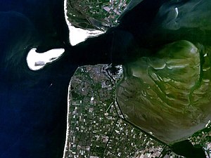
| The Molengat (top left) at low tide, between the island of Texel in the north and the Noorderhaaks sandbank in the southwest | ||
| Connects waters | Marsdiep | |
| with water | North Sea | |
| Separates land mass | Noorderhaaks | |
| of land mass | Texel | |
| Data | ||
| Geographical location | 52 ° 58 '48 " N , 4 ° 42' 54" E | |
|
|
||
| Smallest width | 650 m | |
The Molengat is about 650 meters wide sea channel, a tidal inlet between the island of Texel and the south-west offshore sandbank Noorderhaaks northwest of Den Helder in the Dutch province of North Holland . The navigable part of the Molengat is around 400 meters wide, but only ships with a shallow draft, such as fishing ships and lifeboats, can pass the Molengat. This connection from the Marsdiep to the North Sea is much shorter than the route south around the Norderhaaks and is therefore widely used.
Although the Noorderhaaks migrates towards Marsdiep and Molengat at a speed of around 100 meters per year, it is not certain that it will eventually join Texel as the Onrust sand plate did towards the end of the 19th century. The current in Molengat is still quite strong and the distance between the island and the sandplate has not decreased in recent years. It therefore seems more likely that the Noorderhaaks will spread off the island coast in a northerly direction.
Coastal protection proposal
However, in 2005 a proposal was published that would make the Molengat disappear over a period of around 20 years. In order to protect Texel against erosion and to save the high costs of the annual sand flushing on the southern tip of the island (about 4.5 million euros annually), the landscape architect Lieneke van Campen (* 1973) suggested in her thesis at the Academy for Architecture Amsterdam in 2005 proposed to cut the Noorderhaaks in two parts. A seven-meter-deep gully would be excavated through its northern extension with cutter dredgers , and the sand thus obtained would be piled up on the north side of the new gully, up to a height of about 15 meters. The southern, larger part of the Noorderhaak would remain relatively stable in its current position, and the ebb and flow currents that had previously flowed through the Molengat would increasingly flow through the newly dredged channel. The separated northern part of the Noorderhaak, raised by the sand from the channel, would close the Molengat over the course of about 20 years through wind erosion and further sand deposits and then join Texel.
Individual evidence
- ↑ She was nominated for the Archiprix 2006 by the Academie von Bouwkunst Amsterdam. Jaarboek Academie van Bouwkunst Amsterdam 2004-2005, pp. 266-267

