
The hero
 flag |
 coat of arms |
| province |
|
| mayor | Jeroen Nobel ( PvdA ; acting) |
| Seat of the municipality | The hero |
|
Area - land - water |
178.8 km 2 45.1 km 2 133.7 km 2 |
| CBS code | 0400 |
| Residents | 55,619 (Jan 31, 2019) |
| Population density | 311 inhabitants / km 2 |
| Coordinates | 52 ° 57 ′ N , 4 ° 46 ′ E |
| Important traffic route |
|
| prefix | 0223 |
| Postcodes | 1781-1789 |
| Website | Homepage of Den Helder |
 |
|
Den Helder ( ) is a Dutch municipality on the North Sea coast in the province of North Holland . On January 31, 2019, it had 55,619 residents, according to CBS .
geography

Den Helder is located on the northern tip of the North Holland peninsula, about 80 km north of Amsterdam . From here you can take a car ferry to the neighboring West Frisian island of Texel . The community of Schagen joins south of Den Helder and the community of Hollands Kroon to the south-east .
Between Den Helder and Texel is the Marsdiep , the only access for larger ships from the North Sea to the IJsselmeer and thus to the previously important trading cities and ports of Hoorn , Enkhuizen and Amsterdam . Most of the residents of Den Helder, around 44,000, live in the town of the same name. The other inhabitants of the municipality live in the district Julianadorp (around 15,000) and in the nostalgic whaling village of Huisduinen (around 1000). In addition to these two villages, Den Helder also includes the farmers De Kooy, Friese Buurt, Noorderhaven and Blauwe Keet as well as the holiday village Julianadorp aan Zee.
Landscapes include beaches, forests, dunes, pastures, polder landscapes and mud flats .
climate
The weather in Den Helder is strongly influenced by the North Sea.
| Den Helder, Netherlands | ||||||||||||||||||||||||||||||||||||||||||||||||
|---|---|---|---|---|---|---|---|---|---|---|---|---|---|---|---|---|---|---|---|---|---|---|---|---|---|---|---|---|---|---|---|---|---|---|---|---|---|---|---|---|---|---|---|---|---|---|---|---|
| Climate diagram | ||||||||||||||||||||||||||||||||||||||||||||||||
| ||||||||||||||||||||||||||||||||||||||||||||||||
|
Monthly average temperatures and rainfall for Den Helder, Netherlands
Source: knmi.nl (Klimaatlas van Nederland, normal period 1971–2000), ISBN 90-389-1191-2 KNMI NLweer.com
|
||||||||||||||||||||||||||||||||||||||||||||||||||||||||||||||||||||||||||||||||||||||||||||||||||||||||||||||||||||||||
history

On Texel, the ships of the Dutch East India Company supplied themselves with food and fresh water for centuries before they started their voyage to East India.
Den Helder has always been of great strategic importance and still has a large naval port. The heavily fortified city with its many cannons offered enemy ships that were targeting the rich cities on the Zuiderzee (today's IJsselmeer), an extremely defensive impression. Hence the name "Den Helder", which is derived from Den Helsdeur . Translated into German, this means "To Hell's Gate". There is another version of the origin of the name: The early inhabitants often had to struggle with the natural forces of the North Sea and therefore gave their homeland this name.
The early residents, farmers and fishermen, improved their livelihood by "jutten". That is, they searched the beaches for useful debris. False beacons were also set on stormy nights to beach ships and then loot them and rob the crew. Jutter were therefore wreckers who also accepted the dead. Den Helder is also called Nieuwediep . In the transfiguration of the past, the inhabitants are therefore also known as Nieuwediepers or Jutters (pronounced Jötters).
politics
Distribution of seats in the municipal council
The local elections on March 21, 2018 resulted in the following distribution of seats:
| Political party | Seats | |||
|---|---|---|---|---|
| 2006 | 2010 | 2014 | 2018 | |
| Beter voor Den Helder | - | - | - | 6th |
| CDA | 4th | 3 | 4th | 5 |
| VVD | 6th | 5 | 4th | 4th |
| PVV | - | - | - | 3 |
| D66 | 2 | 4th | 4th | 2 |
| Seniors party | - | - | - | 2 |
| City party Den Helder | 2 | 3 | 11 | 2 |
| ChristenUnie | 2 | 2 | 1 | 2 |
| PvdA | 8th | 4th | 2 | 2 |
| GroenLinks | 1 | 1 | 1 | 1 |
| Behoorlijk Bestuur | - | - | 1 | 1 |
| Community affairs Den Helder | - | - | - | 1 |
| Sociaal Lokaal Den Helder | - | - | - | 0 |
| Helder Onafhankelijk! | - | - | 2 | 0 |
| Vrije socialists | - | - | 1 | 0 |
| VOLUME | - | 5 | - | - |
| SP | 4th | 3 | - | - |
| PRINS-Voor Behoorlijk Bestuur | 1 | 1 | - | - |
| KiesKees | 1 | - | - | - |
| The hero Transparant | 0 | - | - | - |
| total | 31 | 31 | 31 | 31 |
Town twinning
-
 Lüdenscheid , Germany (since 1980)
Economy and Infrastructure
Large areas along the edge of the dune in Den Helder and the surrounding area are used for growing flower bulbs .
The steadily growing tourism (1.5 million overnight stays in 2005) provides additional jobs.
Rail transport
The rail traffic in Den Helder is handled via the station or the main station and the station or the station south . There is (at least) half-hourly traffic in the direction of Amsterdam to the final stop Nijmegen .
Bus transport
The main bus station in Den Helder is also at the main train station. The traffic in and around the city are from about Transdev belonging provider Connexxion performed. During the Dutch summer holidays, line 851 connects the city with the coastal towns.
port
Due to the direct connection with the open sea and good accessibility both from the northeast ( Germany and Scandinavia ) and from the south (Amsterdam and Schiphol ), the port of Den Helder is well suited for transshipment from the sea to inland waterways and the rail network .
The largest employer in the naval city is the Royal Navy , which has been based in 1815, and its related areas, as well as the Nederlandse Kustwacht . The center of today's port area is the “Willemsoord” shipyard founded by Napoleon .
Many supply trips to the drilling platforms in the North Sea begin here.
The fishing is one of the most modern fish auctions in Europe are available.
The ferries of the shipping company Teso to Texel leave from the pier in Den Helder.
Air traffic

The Den Helder Airport is mostly used by helicopters used the day to the oil rigs flying in the North Sea. In 1996 there were 14,000 helicopter flights alone, and in 2003 the airport received approval from the Dutch government to increase the number to 20,000. Various aircraft companies are increasingly managing freight, charter and business trips abroad.
Museums
- the Käthe Kruse toy and doll museum (closed since January 2013)
- the De Oranjerie Botanical Plant Garden
- the museum harbor Willemsoord ("old shipyard Willemsoord") with
- the local lifeboat museum Dorus Rijkers and
- the local naval museum
- the Fort Kijkduin Museum
- Rob Scholte Museum
gallery

cannon

The Prins Hendrik in front of the lifeboat museum

Naval Museum with the Tonijn submarine

Lange Jaap lighthouse seen from Fort Kijkduin
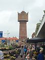
Water tower

The Royal Navy F802 on the quay

Naval port

Training facility for lifeboats

Ferry to Texel


.jpg)


Personalities
- Feike Asma (1912–1984), organist, composer and conductor
- Marleen Barth (* 1964), politician and journalist
- Karel PC de Bazel (1869-1923), architect
- Petrus Johannes Blok (1855–1929), historian
- Edith Bosch (* 1980), judoka
- Comelis Deelder (1853–1928), Old Catholic clergyman and church historian
- Gerardus' t Hooft (* 1946), physicist
- André Jolles (1874–1946), literary scholar
- Eduard Meijers (1880–1954), university professor
- Ed Nijpels (* 1950), politician
- Anton Pieck (1895–1987), painter, draftsman and graphic artist
- Erwin Koen (* 1978), soccer player
- Henri Christiaan Pieck (1895–1972), also called Den Helder, painter, architect and graphic artist, resistance fighter against National Socialism, prisoner in Buchenwald concentration camp and member of the Dutch resistance group
Web links
- Website of the municipality (Dutch)
- Den Helder In: holland.com
Individual evidence
- ↑ Hedzer Faber: Nieuwe waarnemend burgemeester Den Helder confessed: Jeroen Nobel (PvdA). In: Noordhollands Dagblad . Holland Media Combinatie, September 24, 2019, accessed October 4, 2019 (Dutch).
- ↑ Bevolkingsontwikkeling; regio per maand . In: StatLine . Centraal Bureau voor de Statistiek (Dutch)
- ↑ Harald Frater: scinexx | Marsdiep at low tide: View of the strait between Texel and Den Helder. Retrieved June 4, 2018 .
- ↑ http://www.knmi.nl/
- ↑ http://www.nlweer.com/
- ↑ Jutten: de kick van de eerste zijn - light op legends . In: Light op Legends . July 7, 2017 ( lichtoplegend.nl [accessed June 4, 2018]).
- ↑ Den Helder Archieven - Brugwachterverhalen. Retrieved June 4, 2018 (nl-NL).
- ↑ Result of the local elections: 2014 2018 ( Memento of the original from May 1, 2018 in the Internet Archive ) Info: The archive link was inserted automatically and not yet checked. Please check the original and archive link according to the instructions and then remove this notice. , accessed April 30, 2018 (Dutch)
- ↑ Allocation of seats in the municipal council: 2006 2010 2014 2018 ( Memento of the original from May 1, 2018 in the Internet Archive ) Info: The archive link was inserted automatically and has not yet been checked. Please check the original and archive link according to the instructions and then remove this notice. , accessed on April 29, 2018 (Dutch)
- ↑ MARIS BV: Discover & Experience Den Helder - VVV Top van Holland. Retrieved June 4, 2018 (Dutch).
- ↑ Den Helder - On to new shores - MeerART . In: MeerART . May 27, 2015 ( meerart.de [accessed June 4, 2018]).
- ↑ By car or motorcycle on the ferry to Texel? | VVV Texel . In: VVV Texel . December 15, 2015 ( texel.net [accessed June 4, 2018]).
- ^ Algemene informatie - Den Helder Airport. Retrieved June 4, 2018 (Dutch).
- ↑ DagjeWeg.NL
Aalsmeer | Alkmaar | Amstelveen | Amsterdam | Beemster | Mountains | Beverwijk | Blaricum | Bloemendaal | Castricum | Den Helder | Diemen | Drechtland | Edam-Volendam | Enkhuizen | Gooise Meren | Haarlem | Haarlemmermeer | Heemskerk | Heemstede | Heerhugowaard | Heiloo | Hilversum | Hollands Kroon | Hoorn | Huizen | Koggenland | Landsmeer | Langedijk | Laren | Medemblik | Oostzaan | Opmeer | Ouder-Amstel | Purmerend | Schagen | Stede Broec | Texel | Uitgeest | Uithoorn | Velsen | Waterland | Weesp | Wijdemeren | Wormerland | Zaanstad | Zandvoort
Main town: Den Helder
Villages: Huisduinen | Julianadorp
Farmers / hamlets : Friese Buurt | De Kooy | Noorderhaven
Holiday village: Julianadorp aan Zee
Former farmers: Blauwe Keet | Little Keet